
Swinefleet Warping Drain facts for kids
Quick facts for kids Swinefleet Warping Drain |
|
|---|---|

The modern outlet sluice where the Drain enters the River Ouse
|
|
| History | |
| Principal engineer | R Creyke |
| Date of act | 1821 |
The Swinefleet Warping Drain is a special waterway in the East Riding of Yorkshire, England. It was built a long time ago to help farmers. Its main job was to spread rich, silty water over poor land. This made the land much better for growing crops. Today, it mostly helps to drain water away from the land. This stops areas from flooding. Ralph Creyke built the first part of this drain in 1821.
Contents
How the Drain Was Built and Used
Ralph Creyke was a big fan of "warping." This was a clever way to improve farmland. It involved letting water full of mud and silt flow onto barren land. When the water drained away, it left behind a layer of rich soil. This new soil was great for farming.
Creyke lived in Goole and was one of the first people in Yorkshire to do warping for others. In 1812, he warped 55 acres of land in Goole. He used silty water from the Dutch River. Later, he warped even larger areas.
In 1820, he got special permission from the government. This allowed him to build the Swinefleet Warping Drain. He built it south from the River Ouse. His goal was to improve land near Thorne Moors. The first part of the drain was finished in 1821. It helped him warp 430 acres of moorland. In 1825, he even won a gold medal for his work!
Building the Sluice and Drain
Creyke used his experience to build a large sluice at Swinefleet Clough. A sluice is like a gate that controls water flow. This one was 30 feet wide at the bottom. It had two big openings, each 16 feet wide. Four large doors stopped the tide from coming in. But they could be opened to let tidal water flow onto the land.
He built banks along both sides of the main channel. The drain was about 3 miles long at first. The whole project, including buying land, cost £18,000. By 1825, he was warping 1,528 acres for 30 different landowners. They paid him £15 for each acre. Creyke was proud that he worked on a bigger scale. He also did it for less money than others. His drain was 90 feet wide, much wider than earlier ones. This allowed him to warp 500 acres at a time. He even warped land all year round, not just in summer.
Later Years of the Drain
Ralph Creyke passed away in 1828. But his son, also named Ralph Creyke, took over the business. By 1845, about 2,000 acres near Fockerby Common were being warped. This was possible because the Swinefleet Warping Drain was extended. It was made 4.7 miles longer to the east.
The younger Creyke later sold the warping business. He sold it to Makin Durham in 1878. Durham was another expert in warping. He had built his own warping drain from the River Don in 1856.
Around 1875, Durham started the Yorkshire Land and Warping Company. The Swinefleet Warping Drain became part of this company. Over time, people realized that the moors were more valuable for peat. Peat is a type of soil used for fuel and gardening. So, less land was warped for farming. Around 1900, the drain was extended south again. It reached a total length of about 5.6 miles. The drain was last used for warping in 1934.
Drainage Today
The area around Swinefleet has always been low and prone to flooding. In 1793, a law was passed to help drain the land. Later, in 1884, the Reedness and Swinefleet Drainage Commissioners were formed. They managed the land drainage. Today, the Reedness and Swinefleet Internal Drainage Board looks after 41 miles of drainage ditches. They also have one pumping station. Most of the waterways they manage are man-made. This includes the northern part of the Swinefleet Warping Drain.
To the west of the Swinefleet Warping Drain, another group helps with drainage. This is the Goole Fields District Drainage Board. They manage 2,641 acres of land. They keep 9.48 miles of drains clear. They also have a pumping station. Some water from their area goes into the River Ouse. Other water is pumped from Goole Fields Cross Drain into the Warping Drain.
Since peat is no longer extracted from the moors, large areas are now nature reserves. These are called SSSIs. To help the peat moors recover, water levels are kept much higher. English Nature uses pumps to keep the water levels steady.
A new pumping station was built on Blackwater Dike in 2016. It has a special Archimedes' screw pump. This pump helps keep water levels just right for the peat bog. It is powered by a battery pack. The battery gets charged by wind and solar power. This new pump is very efficient. It also allows fish to pass through safely.
Route of the Drain
The Swinefleet Warping Drain starts at Swinefleet Clough. This is a small inlet on the right bank of the River Ouse. It is on the border between the villages of Swinefleet and Goole Fields. The old sluice built by Creyke has been replaced. Now there is a modern concrete structure. This sluice is north of the A161 road.
Most of the drain runs through open countryside. You will mostly see farmhouses nearby. One old farmhouse, Field House Farm, dates back to the late 1700s. It is a Grade II listed building. This means it is a special historic building.
Further south, the drain turns southeast. It is joined by Goosefields Cross Drain. This was once where the Axholme Joint Railway crossed the drain. The railway had a steel bridge, 120 feet long. In 1906, a funny request was made. A group of potato pickers wanted to use the railway bridge to cross the drain. It would save them a long walk! After some discussion, permission was given. The railway closed for passengers in 1933. It stayed open for goods until 1965.
Near Swinefleet Moor Farm, the drain used to turn east. This led towards Swinefleet Peat Works. By 1906, the drain continued south. A narrow railway, 3 feet wide, ran next to the drain from the peat works. It crossed the main drain and went south. The old tramway bridge is still there today. Its rails are still in the ground.
At Blackwater Dike, the drain leaves East Yorkshire. It enters North Lincolnshire. The drain probably ends around Thousand Acre Drain. Beyond that, the drains are much narrower.
Earnshaw's Warping Drain
Another waterway nearby is Earnshaw's Warping Drain. It flows into the River Ouse. This drain was built in the 1800s. A local farmer named George Rawden Earnshaw built it. He lived in Old Goole.
The A161 road crosses this drain on a bridge. There is also a sluice next to the road. Both the bridge and the sluice are Grade II listed. This means they are important historic structures. The sluice was made of stone. It had a wooden gate and an iron system to open and close it.
Nearby, on the right bank, is Goole Hall. This is a very old house built in 1820. It is also a Grade II* listed building. The drain flows south-southwest. It passes Goole Grange. Then it turns west. It connects with other drains that carry water from the moors.
Water Quality
The Environment Agency checks the water quality of rivers in England. They give each river an overall "ecological status." This status can be high, good, moderate, poor, or bad. They look at things like the types of bugs, plants, and fish in the water. They also check for chemicals. Chemical status is either good or fail.
In 2016, the water quality for the Swinefleet Warping Drain was checked.
| Section | Ecological Status |
Chemical Status |
Overall Status |
Length | Catchment | Channel |
|---|---|---|---|---|---|---|
| Swinefleet Warping Drain Source to River Ouse | Moderate | Good | Moderate | 2.9 miles (4.7 km) | 7.99 square miles (20.7 km2) | artificial |
The water quality is not "good" for a few reasons. The main reasons are changes made to the drain itself. Also, nutrients from farm land can get into the water.
Images for kids
-
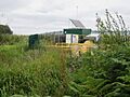
The English Nature Pumping Station on Blackwater Dike helps keep water levels right in the Humberhead Peatlands Nature Reserve. It pumps water into the Swinefleet Warping Drain.

