
Swithland Reservoir facts for kids
Quick facts for kids Swithland Reservoir |
|
|---|---|

View from the causeway at the southern end, with Brazil Island in the centre and the railway viaduct to the right.
|
|

Swithland Reservoir
Location in Leicestershire
|
|
| Location | Leicestershire |
| Coordinates | 52°43′20″N 1°10′25″W / 52.72222°N 1.17361°W |
| Type | Reservoir |
| Primary inflows | Lingdale Brook, Swithland Brook, Hallgates Brook, Bradgate Brook |
| Primary outflows | Buddon Brook |
| Basin countries | United Kingdom |
| Water volume | 600 million imperial gallons (2,200 acre⋅ft) |
| Settlements | Swithland |
Swithland Reservoir is a large reservoir in Leicestershire, England. It is located near the village of Swithland, which gives it its name. The reservoir is also close to Rothley and the Mountsorrel Quarry. It is part of a special natural area called the Buddon Wood and Swithland Reservoir Site of Special Scientific Interest (SSSI). This means it's a protected place because of its important wildlife and geology.
Contents
Why Swithland Reservoir Was Built
In the late 1800s, the city of Leicester was growing very quickly. More and more people needed fresh water for their homes. To meet this demand, the city decided to build several reservoirs.
The Swithland Reservoir was one of the last big reservoirs built during this time. Work started in 1894 and finished in 1896. It was designed by John Breedon Everard. To help with construction, a temporary railway line was built from Mountsorrel to bring in materials. The reservoir officially opened on September 10, 1896. It was also used as a water treatment plant in the past.
Where the Reservoir Is Located
The reservoir was built in a valley that used to be covered in trees. This valley was surrounded by six villages: Swithland, Rothley, Woodhouse, Quorn, Mountsorrel, and Woodhouse Eaves.
Several streams flow into the reservoir, including Lingdale Brook, Swithland Brook, Hallgates Brook, and Bradgate Brook. The water then flows out as Buddon Brook, which eventually joins the River Soar.
When the reservoir was built, the road from Swithland had to be moved. A bridge was also built at the southern end. To create the reservoir, many trees and hedgerows were removed from the valley.
Brazil Island
Inside the reservoir, there is an island called Brazil Island. This island is actually a part of Brazil Wood that stayed above the water when the valley was flooded. There are weirs (small dams) on both sides of the island. Brazil Island used to be a place for game animals, but a fire destroyed it in 1938.
Steam Trains and Viaducts
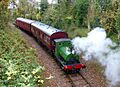
Around the same time the reservoir was being built, a major railway line, the Great Central Railway, was also constructed. This railway crossed over the reservoir on two large bridges called viaducts. Brazil Island is located between these viaducts.
The railway opened in 1899 but was closed in the 1960s. However, people worked hard to reopen the section in Leicestershire. Now, steam trains run again between Leicester and Loughborough. The viaduct section has two tracks, and with the completion of the Swithland Sidings signal box in 2012, steam trains can use both tracks across the reservoir. They can also connect to the Mountsorrel branch line.
How Water Is Provided

The dam at Swithland Reservoir is very long, about 404 yards. It is 26 feet wide at the top and 48 feet wide at the bottom. It was built using concrete and water-clay.
Next to the dam is a draw-off tower. This tower originally took water from the reservoir to six large filter beds. These filter beds cleaned the water before it was pumped to other reservoirs. Today, raw water from Swithland Reservoir is pumped to the nearby Cropston Water Treatment Works for cleaning. After treatment, it goes into the Hallgates Service Reservoir. Many of the buildings at Swithland Reservoir, including parts of the pumping station, are protected as Grade II listed buildings.
The reservoir was designed to hold 600 million gallons of water. This was thought to be enough for 300,000 people. However, there were some challenges. By 1898, Leicester needed even more water from other areas. In 1909, water supply from Swithland was stopped for a short time because of "vegetable growth" (like algae) due to warm weather.
A Special Scientific Site (SSSI)
Swithland Reservoir is part of the Buddon Wood and Swithland Reservoir biological SSSI. This area is very important for its wildlife. Buddon Wood, which is next to the reservoir, is also important for its geology (rocks and landforms).
The Mountsorrel granite found in Buddon Wood is very valuable for making crushed stone used in roads and concrete. Quarrying in this area began in the 1970s.
The SSSI area is incredibly rich in different kinds of plants and animals. Over 200 types of plants, many spider species, 20 butterfly species, and 200 moth species have been found here. The ancient woodland of Buddon Wood and the areas around the reservoir have been home to these species for thousands of years.
The reservoir itself has created new habitats for wetland plants and, especially, for birds. Between 1940 and 2000, 218 different types of wild birds were seen around the reservoir. Many of these birds use the open water as a place to rest and feed in winter. It's also a vital stop for birds migrating (traveling) through the area.
Images for kids
-
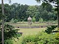
Reservoir filter beds, laid out like formal gardens.
-
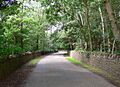
Buddon Wood. The strip of woodland beside Kinchley Lane is the last remnant of ancient woodland fringing Mountsorrel Quarry
-
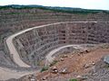
Mountsorrel Quarry is the result of a massive excavation of roadstone on the former site of Buddon Wood, the richest wildlife site in Leicestershire.
-
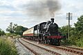
The Great Central Railway, now a steam preservation railway with two tracks across the viaduct.
-
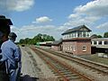
Swithland Sidings on the Great Central Railway.
-
Initially a handy place to have an engine shed, the old Mountsorrel quarry line is now running over 2km of track.
-
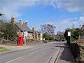
Main Street, Swithland


.jpg)

