
Têt (river) facts for kids
Quick facts for kids Têt |
|
| La Têt | |
| River | |
 Têt near Villefranche-de-Conflent
|
|
| Country | France |
|---|---|
| Region | Occitanie |
| Department | Pyrénées-Orientales |
| Commune | Angoustrine-Villeneuve-des-Escaldes |
| Tributaries | |
| - left | Castellane, Caillan |
| - right | Riberola, Carança, Mantet, Rotja, Cady, Lentillà, Lliscou, Boulès, Basse |
| City | Perpignan |
| Source | at the foot of Pic Carlit |
| - location | Angoustrine-Villeneuve-des-Escaldes, Pyrénées-Orientales, France |
| - elevation | 2,405 m (7,890 ft) |
| - coordinates | 42°36′58″N 1°57′23″E / 42.6162°N 1.9564°E |
| Mouth | Mediterranean Sea |
| - location | Canet-en-Roussillon, Pyrénées-Orientales, France |
| - elevation | 0 m (0 ft) |
| - coordinates | 42°43′02″N 3°02′27″E / 42.7173°N 3.0408°E |
| Length | 115.8 km (72 mi) |
| Basin | 1,369 km² (529 sq mi) |
| Discharge | for Perpignan |
| - average | 9.5 m³/s (335 cu ft/s) |
The Têt (Catalan: Tet) is the biggest river in Roussillon, a region in southeastern France. The valley created by this river is called the Valley of the Têt. It was even named a "Region of Art and History" by the French government. This means it has many important cultural and historical places.
Contents
The Têt River's Journey
The Têt river is about 115.8 kilometers (72 miles) long. It starts high up in the mountains. Its source is on the northeastern side of Pic Carlit. This mountain is very tall, and the river begins at an elevation of 2,405 meters (7,890 feet). This starting point is in a town called Angoustrine-Villeneuve-des-Escaldes.
The river flows across the Pyrénées-Orientales area. This area is also known as Northern Catalonia. The Têt travels from west to east. Finally, it reaches the Mediterranean Sea near the city of Perpignan (Catalan: Perpinyà).
Rivers Joining the Têt
The Têt river has many smaller rivers and streams that flow into it. These are called tributaries. There are 43 tributaries in total! Here are some of the main ones:
Tributaries from the Right
These rivers join the Têt from its right side as you look downstream:
- Riberola (also called Torrent de la Valleta), which is 10.3 km (6.4 miles) long.
- Carança, 15.3 km (9.5 miles) long.
- Mantet (also known as Rivière du Ressac or Ruisseau d'El Callau), 18.5 km (11.5 miles) long.
- Rotja, 23.3 km (14.5 miles) long.
- Cady, 19.2 km (11.9 miles) long, which flows from the Le Canigou mountain.
- Lentillà, 24 km (14.9 miles) long.
- Lliscou, 11.8 km (7.3 miles) long.
- Boulès (or Bolès), 34.5 km (21.4 miles) long.
- Basse, 11.6 km (7.2 miles) long.
Tributaries from the Left
These rivers join the Têt from its left side as you look downstream:
- Castellane, 27 km (16.8 miles) long.
- Caillan, 20.9 km (13 miles) long.
Towns Along the Têt
Many towns and cities are located along the Têt river. Here are some of them, with their Catalan names in parentheses:
- Mont-Louis (Mont-Lluis)
- Olette (Oleta)
- Villefranche-de-Conflent (Vilafranca de Conflent)
- Prades (Prada de Conflent)
- Perpignan (Perpinyà)
Images for kids
-
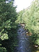
The Têt river near Villefranche-de-Conflent
-
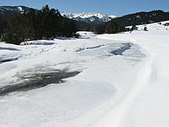
Frozen Têt near Bolquère
-
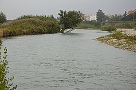
The Têt river in Perpignan
-
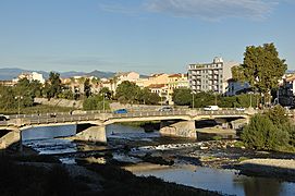
The Têt river in Perpignan


See also
 In Spanish: Río Têt para niños
