Taüll facts for kids
Quick facts for kids
Taüll
|
|
|---|---|
|
Locality
|
|
 |
|
| Country | |
| Autonomous community | |
| Province | Lleida |
| Comarca | Alta Ribagorça |
| Municipality | Vall de Boí |
| Population | |
| • Total | 272 |
| Time zone | UTC+1 (CET) |
| • Summer (DST) | UTC+2 (CEST) |
| Postal code |
25528
|
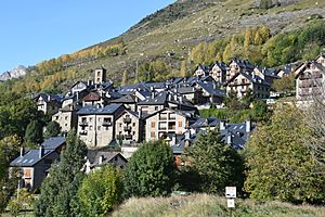
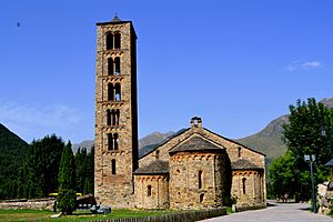
Taüll (pronounced tah-OOL) is a charming town in the province of Lleida, located in Catalonia, Spain. It is famous for its beautiful Romanesque architecture, especially the church of Sant Climent de Taüll. This church is an amazing example of old Romanesque style. It is part of the Catalan Romanesque Churches of the Vall de Boí, which are recognized as a World Heritage Site by UNESCO.
Taüll is one of the small villages that make up the municipality of Vall de Boí. This area is found in the wider region called Alta Ribagorça.
Contents
What Does the Name Taüll Mean?
The name Taüll has an interesting history. According to a Catalan expert named Joan Coromines, the name likely comes from old words. These words, from the Ibero-Basque language, mean "the village of the (mountain's) door." This makes sense because of Taüll's location near mountains.
Where is Taüll Located?
Taüll is nestled at the bottom of the Vall de Boí. In 2008, about 270 people lived in the town. To reach Taüll from the city of Lleida, you can take the N-230 road. This road goes through the village of Pont de Suert.
After Pont de Suert, you turn right onto the L-500 road. This is the main road for the Valley of Boí. You will pass Barruera and then reach another fork in the road. Turn right again onto the L-501. This road will take you to the villages of Boí and Taüll. It ends at the Boí-Taüll ski resort.
A Look into Taüll's Past
In the year 806, the Count of Toulouse helped free this region from Muslim rule. This meant the people no longer had to pay tribute. Later, the Valley of Boí became part of the county of Pallars. This area was under the control of the Church of Urgell.
In 911, there was a big disagreement with the Church of Urgell. A new church area was created, including Pallars and Ribagorça. However, in 949, these two areas separated again. Ribagorça stayed with the new church area, while Pallars returned to the Church of Urgell.
There were more legal problems, and the two areas joined again. The region finally found some peace and prosperity in the early 12th century. This was thanks to King Alfons I "El Batallador". The local lords helped him in his efforts to take back land from the Muslims. This period of stability brought wealth to the region.
The lords of Erill controlled the villages of Taüll and Boí. They became very wealthy, which allowed them to rebuild many churches in the valley. They built the churches of Sant Climent, Sant Martí (which was later destroyed by an avalanche in the 1970s), and Santa Maria. These churches were built in a rich Romanesque architecture style. They also had beautiful items used in church services.
The Erill lords were a very important family in the Pyrenees mountains. They are known for planning and building the churches in the Valley of Boí. Their castle was in the now-abandoned village of Erillcastell.
How People Make a Living in Taüll
Today, Taüll's economy mostly relies on tourism. People visit in both summer and winter. Besides its famous Romanesque churches, the town offers many hotels and restaurants. Visitors can also enjoy guided hikes.
Even with tourism, traditional activities like raising livestock are still important. This means that farming animals continues to be a part of the village's economy.
Taüll's Natural Surroundings
Taüll is located at an altitude of 1,520 meters (about 4,987 feet). It sits in the Sant Martí valley, which is a smaller valley within the larger Valley of Boí. The closest river is the Sant Martí river, which flows into the Noguera de Tor river.
A natural ditch, or ravine, divides the village into two main parts. These parts are called La Guinsa and Lo Barri. La Guinsa stretches from the entrance of the village up to the ravine. Lo Barri goes from the ravine to the higher parts of the village.
Important Places to See
- The Romanesque Church of Sant Climent de Taüll.
- The Romanesque church of Santa Maria de Taüll.
See also
 In Spanish: Tahull para niños
 | Mary Eliza Mahoney |
 | Susie King Taylor |
 | Ida Gray |
 | Eliza Ann Grier |


