
Tagbilaran facts for kids
Quick facts for kids
Tagbilaran
San José de Tagbilarán
|
|||
|---|---|---|---|
|
Component city
|
|||
| City of Tagbilaran | |||
.jpg)
Plaza Rizal
|
|||
|
|||

Map of Bohol with Tagbilaran highlighted
|
|||
|
OpenStreetMap
|
|||
.svg)
Tagbilaran
Location in Philippines
|
|||
| Country | Philippines | ||
| Region | Central Visayas | ||
| Province | Bohol | ||
| District | [[{{#property:P7938}} | — Lua error in Module:Wd at line 1804: attempt to index field 'wikibase' (a nil value).]] | ||
Incorporated
|
9 February 1742 1 July 1966 |
||
| Barangays | 15 (see Barangays) | ||
| Government
|
|||
| • Type | Sangguniang Panlungsod | ||
| Area | |||
| • Total | 36.50 km2 (14.09 sq mi) | ||
| Elevation | 39 m (128 ft) | ||
| Highest elevation | 449 m (1,473 ft) | ||
| Lowest elevation | 0 m (0 ft) | ||
| Population
(2020 census)
|
|||
| • Total | 104,976 | ||
| • Density | 2,876.1/km2 (7,448.9/sq mi) | ||
| • Households | 23,078 | ||
| Economy | |||
| • Income class | 3rd city income class | ||
| • Poverty incidence |
|
||
| • Revenue | ₱ 1,149 million (2022) | ||
| • Assets | ₱ 2,917 million (2022) | ||
| • Expenditure | ₱ 938.7 million (2022) | ||
| • Liabilities | ₱ 402.2 million (2022) | ||
| Service provider | |||
| • Electricity | Bohol Light Company (BLCI) | ||
| Time zone | UTC+8 (PST) | ||
| ZIP code |
6300
|
||
| PSGC |
[https://psa.gov.ph/classification/psgc/?q=psgc/barangays/{{#pro000®code={{&provcode=
|
||
| IDD : area code | +63 (0)38 | ||
| Native languages | Boholano dialect Cebuano Tagalog |
||
| Website | tagbilaran |
||
.png)

Tagbilaran, officially known as the City of Tagbilaran, is a special type of city called a component city. It is the capital of the province of Bohol in the Philippines. In 2020, about 104,976 people lived there, making it the most populated city in Bohol.
Tagbilaran is the main entry point to Bohol. It is about 630 kilometers (391 miles) southeast of Manila, the country's capital. It is also about 72 kilometers (45 miles) south of Cebu City, which is the capital of the region.
Contents
- What's in a Name?
- A Look Back: Tagbilaran's History
- Tagbilaran's Location and Landscape
- How Many People Live Here?
- Tagbilaran's Economy
- City Government
- Fun Things to Do: Tourism
- Getting Around: Transportation
- Staying Healthy: Healthcare
- Learning and Education
- Famous People from Tagbilaran
- Images for kids
- See also
What's in a Name?
The name "Tagbilaran" comes from old stories. Some say it comes from "Tagubilaan". This means "to hide" (tagu) from the "Blaan people", who were known to raid islands in the Visayas.
Another idea is that the name comes from tinabilan, which means "shielded". This suggests the town was protected from invaders by Panglao Island.
A Look Back: Tagbilaran's History
Even before the Spanish arrived in the Philippines, Tagbilaran was a busy trading place. It traded with China and other parts of Asia. The area was once home to an old settlement called Bo-ol.
In 1565, a Spanish explorer named Miguel López de Legazpi met a local leader, Datu Sikatuna, here. They made a famous blood compact, a special agreement of peace and friendship.
The town of San José de Tagbilaran was officially started on February 9, 1742. It was named after St. Joseph the Worker. Later, on July 1, 1966, it became a chartered city.
Tagbilaran was occupied by the United States during the Philippine–American War. It was also occupied by Japanese forces during World War II on May 17, 1942.
Sitio Ubos: The Old Town Center
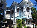
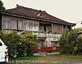
Sitio Ubos (which means Lower Town) is the oldest part of Tagbilaran. It was a busy trading port from the 1600s until the early 1900s. Because of its long history, it has many old heritage houses.
However, Sitio Ubos became less important as a port when a causeway to Panglao Island was built. Many of its old houses were either torn down or left to decay. In 2002, Sitio Ubos was recognized as a "Cultural Heritage Area" because of its history. Some of the old houses still standing today include the Rocha–Suarez House and the Hontanosas House.
Important Moments in History
One very important event in Philippine history is the blood compact between Datu Sikatuna and Captain Miguel López de Legazpi. This event is even shown in a famous painting by Juan Luna. For a long time, people believed it happened in Bool, a district of Tagbilaran.
However, in March 2006, the National Historical Commission of the Philippines corrected this. They placed a marker in Villalimpia, Loay. It states that the blood compact actually happened in Hinawanan Bay, Loay, on March 25, 1565. It was a sign of friendship between the Spanish and the Boholanos.
During the Japanese occupation in World War II, the city government moved from the main town to Tiptip. There was also a brave fight called the Battle of Ubujan. A local guerrilla group fought against the Japanese soldiers.
The 2013 Earthquake
On October 15, 2013, a strong earthquake with a magnitude of 7.2 hit Bohol. Its center was near Sagbayan, Bohol. Tagbilaran was affected, with some people losing their lives and others getting injured. Buildings, including the seaport, airport, and city hall, were also damaged.
Tagbilaran's Location and Landscape

Tagbilaran is shaped like a strip of land. It has two hills: Elley Hull (100 meters high) in the south and Banat-i (145 meters high) in the north.
The city has a coastline of about 13 kilometers (8 miles) on the southwestern part of Bohol Island. It shares its borders with the towns of Cortes, Corella, and Baclayon.
Weather in Tagbilaran
| Climate data for Tagbilaran City (1981–2010) | |||||||||||||
|---|---|---|---|---|---|---|---|---|---|---|---|---|---|
| Month | Jan | Feb | Mar | Apr | May | Jun | Jul | Aug | Sep | Oct | Nov | Dec | Year |
| Mean daily maximum °C (°F) | 31.1 (88.0) |
31.6 (88.9) |
32.4 (90.3) |
33.3 (91.9) |
33.5 (92.3) |
32.9 (91.2) |
32.5 (90.5) |
32.8 (91.0) |
32.8 (91.0) |
32.4 (90.3) |
32.0 (89.6) |
31.4 (88.5) |
32.4 (90.3) |
| Daily mean °C (°F) | 26.8 (80.2) |
27.1 (80.8) |
27.6 (81.7) |
28.5 (83.3) |
29.0 (84.2) |
28.7 (83.7) |
28.4 (83.1) |
28.7 (83.7) |
28.6 (83.5) |
28.2 (82.8) |
27.8 (82.0) |
27.2 (81.0) |
28.0 (82.4) |
| Mean daily minimum °C (°F) | 22.6 (72.7) |
22.5 (72.5) |
22.8 (73.0) |
23.6 (74.5) |
24.4 (75.9) |
24.4 (75.9) |
24.3 (75.7) |
24.5 (76.1) |
24.4 (75.9) |
24.0 (75.2) |
23.6 (74.5) |
23.0 (73.4) |
23.7 (74.7) |
| Average rainfall mm (inches) | 101.0 (3.98) |
79.6 (3.13) |
76.6 (3.02) |
67.5 (2.66) |
81.5 (3.21) |
128.2 (5.05) |
126.7 (4.99) |
116.3 (4.58) |
126.5 (4.98) |
176.3 (6.94) |
178.9 (7.04) |
153.6 (6.05) |
1,412.6 (55.61) |
| Average rainy days (≥ 0.1 mm) | 14 | 11 | 11 | 9 | 10 | 15 | 15 | 13 | 14 | 18 | 18 | 16 | 164 |
| Average relative humidity (%) | 83 | 81 | 79 | 78 | 79 | 81 | 82 | 80 | 81 | 83 | 85 | 84 | 81 |
| Source: PAGASA | |||||||||||||
Barangays: City Neighborhoods
Tagbilaran is divided into 15 smaller areas called barangays. Each barangay has its own smaller sections called puroks and sometimes sitios.
In 2020, the city's population was 104,976. Almost half of the people live in the four main urban districts. This is where most of the city's businesses and shops are found.
|
|
||||||||||||||||||||||||||||||||||||||||||||||||||||||||||||||||||||||||||||||||||||||||||||||||||||||||||||||||||||||||||||||||||||||||||||||||||||||||||||||||||||||||||||||||||||||||||||||||||||||


How Many People Live Here?
Tagbilaran's Economy

| Source: Philippine Statistics Authority |
|
Tagbilaran is the main business center of Bohol province. It is also important for government, education, and transportation. Many local and international visitors come to Bohol through Tagbilaran's port.
Some well-known local companies based in the city include Alturas Group (which runs Alturas Mall and Island City Mall) and Bohol Quality Corporation.
City Government
.png)
The city is led by a mayor. In the past, it was governed by officials called gobernadorcillo and presidente municipal.
Mayor of Tagbilaran
Fun Things to Do: Tourism

Tagbilaran is a great starting point for exploring Bohol's famous attractions. These include the Chocolate Hills, tiny tarsiers, beautiful white sandy beaches, and amazing dive spots. The city also has many old heritage sites and stone churches. With its hotels, resorts, and restaurants, Tagbilaran often hosts national meetings and events.
Festivals and Celebrations
- Saulog-Tagbilaran Festival: This festival takes place every year from April 20 to May 2. It includes street dancing, a boat parade, evening activities, and a beauty pageant. Families in Tagbilaran invite friends and relatives for meals during this special time.
- Sandugo Festival: This annual festival in Tagbilaran celebrates the historic blood compact between Miguel López de Legazpi and Datu Sikatuna. It is held every July, matching the city's Charter Day on July 1 and Bohol's Province Day on July 22.
Getting Around: Transportation

Within Tagbilaran, you can travel by tricycles, multicabs, taxis, and jeepneys. For trips outside the city, people usually hire buses, taxis, or vans. The Integrated Bus Terminal (IBT) in Dao is where public transport for inter-city routes starts. It also serves as a stop for buses going from Tagbilaran to Metro Manila.
The city is connected by sea to major port cities in the Visayas and Mindanao. Its link to Cebu City is very important for business. A fast ferry ride to Cebu City takes about 2 hours.
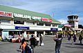
The Bohol–Panglao International Airport is located southwest of the city on Panglao Island. It opened on November 27, 2018, replacing the old Tagbilaran Airport. This airport is the main gateway for air travel to Bohol. Airlines like Cebu Pacific, PAL Express, and AirAsia Philippines offer flights mainly to Manila and Clark. A flight to Manila takes about 1 hour and 15 minutes.
Staying Healthy: Healthcare
Tagbilaran has both public and private hospitals and clinics. These facilities serve the health needs of the city and the rest of Bohol province. For very complex medical cases, people sometimes go to nearby Cebu City because of more specialized facilities there.
Here are some of the healthcare facilities in Tagbilaran:
- Holy Name University Medical Center Foundation, Inc.
- Borja Family Hospital Corporation
- Englewood Hospital
- Governor Celestino Gallares Memorial Regional Hospital (public hospital)
- MMG Bohol Cooperative Hospital
- Ramiro Community Hospital (private hospital)
- Bohol St. Jude General Hospital
- Tagbilaran Community Hospital
- Tagbilaran Maternity and Children's Hospital
Learning and Education
As the capital of Bohol, Tagbilaran is the main center for education in the province. All of Bohol's universities are located here, along with other well-known schools.
Here are some of the colleges and universities in Tagbilaran:
- Tagbilaran City College
- Bohol Island State University (BISU)
- BIT International College (BIT-IC)
- Bohol Technical Institute (BTI)
- Bohol Wisdom School
- Holy Name University
- Holy Spirit School of Tagbilaran, Inc.
- Immaculate Heart of Mary Seminary (IHMS)
- PMI Colleges Bohol
- University of Bohol
Famous People from Tagbilaran
Sports
- Mark Magsayo – Boxer
- Czar Amonsot – Boxer
- Vanessa Sarno – Medalist in Weightlifting
Academics
- José Abueva – Academician
Culture and Arts
- Napoleon Abueva – Artist
Entertainment and Media
- Colet Vergara - Member of Pinoy pop group Bini
- Rich Asuncion – TV Actress
- Maxelende Ganade – Singer-songwriter
- Luke Mejares – TV Personality/Singer
- Hazel Mae - Sportscaster
- Marco Sison – Singer
- Isagani Yambot – Journalist
Politics
- Jose Clarin – Former President pro tempore of the Senate of the Philippines (1934–1935)
- Cecilio Putong – Secretary of Education (1952)
- Fermin Torralba – Secretary of the Philippine Senate (1931–1935)
- Nestor Principe - Martial arts instructor and activist during the Marcos dictatorship
Images for kids
-

Aerial view of Tagbilaran, 1937
-
Caseñas Ancestral House
-
Casa Rocha
-

Former flag of Tagbilaran
-
Former Tagbilaran Airport terminal building


See also
 In Spanish: Tagbilaran para niños
