
Tainter Lake facts for kids
Quick facts for kids Tainter Lake |
|
|---|---|
 |
|

Tainter Lake
Location in Wisconsin
|
|
| Location | Dunn County, Wisconsin |
| Coordinates | 44°56′06″N 91°53′19″W / 44.93500°N 91.88861°W |
| Type | Reservoir |
| Primary inflows | Red Cedar River, Hay River |
| Primary outflows | Red Cedar River |
| Basin countries | United States |
| Surface area | 1,752 acres (7.1 km2) |
| Max. depth | 37 ft (11 m) |
| Shore length1 | 25.7 mi (41.4 km) |
| Surface elevation | 872 ft (266 m) |
| Settlements | Tainter |
| 1 Shore length is not a well-defined measure. | |
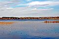
Tainter Lake is a man-made lake in north central Dunn County, Wisconsin. It was formed on the Red Cedar River where it meets the Hay River. The lake was created by a hydroelectric dam about 3 miles (5 km) downstream at Cedar Falls. Tainter Lake is a popular spot for vacations and fishing. It covers an area of about 2 square miles (5.2 km2).
Contents
How Tainter Lake Was Formed
Before the dam was built at Cedar Falls, Tainter Lake did not exist. The idea for the dam came from Andrew Tainter (1823-1899). He was a very rich lumber baron, meaning he owned a lot of forests and sawmills.
Andrew Tainter was a partner in Knapp, Stout and Company. This was the biggest lumber mill in the United States in the 1870s. They owned huge amounts of pine forest, about 115,000 acres (46,540 ha). The company also employed 1,200 men. They had logging camps on almost every stream that flowed into the Red Cedar River.
The company's main mill was on the Menomonee River, which is what the Red Cedar was often called back then. This area became known as Menomonie. The company continued logging until 1899. By then, most of the forests were cut down. The mill at Cedar Falls closed in 1901.
Changes to the Land
During the logging years, large areas of forest near the Red Cedar River were cleared. Farmers also moved to the area. They removed tree stumps and started farming. Much of this new farmland was on slopes leading to the river.
Decades later, these changes to the land caused problems for Tainter Lake. Maps from the mid-1880s show that the area was mostly forest (90%). By the early 1980s, less than 50% was forest, and 40% was farmland. This change from forests to farms is a big reason for the algae problems in Tainter Lake today.
Lake Location and Features
Tainter Lake is located in the Town of Tainter in northern Dunn County, Wisconsin. A small channel splits the lake into two parts: North Tainter and South Tainter. This channel is one of the narrowest parts of the lake, only about 50 feet wide. It also holds the deepest part of the lake, which is 35 feet deep. On average, the lake is about 20 feet (6.1 m) deep.
There are a few small resorts along the lake's shores. North Tainter is generally better for fishing than the southern part. This is because North Tainter has many fish cribs. These are structures placed in the water to give fish places to hide and live. North Tainter is also shallower, which is good for many fish species that lay their eggs in slow-moving, shallow water.
The Red Cedar River and the Hay River are the main sources of water for North Tainter Lake. Both rivers flow through farm fields north of the lake. A group called the TMLIA (Tainter Menomin Lake Improvement Association) is working hard to fix the algae problem in the lake. Their efforts are helping the lake improve.
South of the Cedar Falls dam, the Red Cedar River flows for about three miles (5 km). It then reaches Lake Menomin, which was also created by a dam on the Red Cedar. Since the Lake Menomin dam is the last one on the Red Cedar River before it reaches the Mississippi River, you can legally fish that part of the river even when it's not fishing season.
Fishing in Tainter Lake
Many types of fish live in Tainter Lake. You can often find walleye, black crappie, and bluegill. Other fish you might catch include yellow perch, northern pike, common carp, white bass, and bowfin.
Water quality can be a problem for fishing, especially in the summer. Large blooms of algae make the water cloudy. This makes it hard for fish to see bait fish, and also hard for fishermen to catch them. Walleye are very popular with fishermen all year round. Most walleye caught are less than 15 inches long. If you catch a walleye between 20 and 24 inches, you must release it.
Cedar Falls Dam and Power Plant
Xcel Energy runs the Cedar Falls Hydroelectric Project. This project creates Tainter Lake. The project includes a dam that is 510 feet (155.4 m) long and 50 feet (15.2 m) high. It is located near Cedar Falls, Wisconsin.
The power station has three large generators. Each one can produce 2,000 kilowatts of electricity. Together, they can make 7.1 megawatts of power. This facility can produce over 33.6 million kilowatt hours of electricity every year. It works by using the natural flow of the river.
The Cedar Falls dam was first built from timber. It was replaced with a concrete dam in 1910. New generators were added in 1912 and 1915. The project has not changed much since then.
In 2005, the dam's gates were updated. They now have special "Obermeyer spillway gates" with inflatable rubber parts. These new gates help keep the lake's water level more consistent throughout the year. Before these new gates, the dam used plywood gates. These old gates were designed to break when the ice melted.
When the inflatable gates were installed, the lake's water level dropped about 5 or 6 feet (1.5 or 1.8 m). This caused some of the land where people had their docks to erode. When the water level went back to normal, people living on the lake had to shorten their docks because the water had become much deeper.
Images for kids
-
Tainter Lake
