
Tak Province facts for kids
Quick facts for kids
Tak
ตาก
|
|||
|---|---|---|---|

Ping River
|
|||
|
|||

Map of Thailand highlighting Tak Province
|
|||
| Country | Thailand | ||
| Region | Lower northern | ||
| Capital | Tak | ||
| Largest City | Mae Sot | ||
| Area | |||
| • Total | 16,407 km2 (6,335 sq mi) | ||
| Area rank | Ranked 4th | ||
| Population | |||
| • Total | 654,676 | ||
| • Rank | Ranked 39th | ||
| • Density | 40/km2 (100/sq mi) | ||
| • Density rank | Ranked 76th | ||
| Human Achievement Index | |||
| • HAI (2017) | 0.5631 "low" Ranked 61st |
||
| Time zone | UTC+7 (ICT) | ||
| Postal code |
63xxx
|
||
| Calling code | 055 | ||
| ISO 3166 code | TH-63 | ||


Tak (Thai: ตาก) is one of the northern provinces in Thailand. It is a large area, covering about 16,406.6 square kilometers. In 2013, over 532,000 people lived there. The province is led by a Governor, who helps manage the area.
Location and Neighbors
Tak province is located in the northern part of Thailand. It shares its borders with many other provinces. To the north, you'll find Mae Hong Son Province, Chiang Mai Province, Lamphun province, and Lampang Province.
To the east, Tak borders Sukhothai Province, Kamphaeng Phet Province, Nakhon Sawan Province, and Uthai Thani Province. To the south, it touches Kanchanaburi Province.
The western side of Tak province is very important. It shares a border with Kayin State in Myanmar. This border is often marked by the Moei River.
How Tak is Organized
Tak province is divided into smaller parts to help manage everything. These parts are called amphoe, which are like districts. There are 9 districts in Tak.
Each district is then split into even smaller areas called tambon, or subdistricts. Tak has 63 subdistricts. Finally, these subdistricts are made up of many muban, which are villages. There are 493 villages across Tak province.
Here are the 9 districts of Tak:
|
|
Images for kids
-
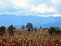
Cornfields and the mountains of Burma south of Mae Sot
-

Namtok Pha Charoen waterfall
-
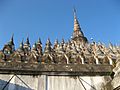
Wat Mani Phraison temple
-
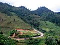
Road 1090 towards Umphang
-
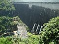
Bhumibol Dam
-
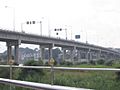
Thai-Myanmar Friendship Bridge over Moei River, part of AH1
-
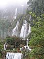
Thi Lo Su Waterfall, Tak


See also
 Learn more in Spanish: Provincia de Tak para niños
