
Chiang Mai Province facts for kids
Quick facts for kids
Chiang Mai
|
||
|---|---|---|
| เชียงใหม่ | ||
|
||

|
||
| Capital | Chiang Mai | |
| Area | ||
| • Province | 20,107 km2 (7,763 sq mi) | |
| Population
(2014)
|
||
| • Province | 1,678,284 | |
| • Density | 83.4676/km2 (216.180/sq mi) | |
| • Urban | 960,906 | |
| Human Development Index | ||
| • HDI (2010) | 0.792 (high) (rank?) | |
| Postal code |
50xxx
|
|
| Calling code | 053 | |
| Vehicle registration | เชียงใหม่ | |
| Accession into Siam (Thailand) | 1910 | |
| Website | http://www.chiangmai.go.th | |

Chiang Mai (Thai: เชียงใหม่) is the second-largest province in Thailand. It is located in the northern part of the country. Chiang Mai borders Chiang Rai to the northeast and Burma to the north. It also shares borders with Lampang, Lamphun, Tak, and Mae Hong Son. The capital city, also called Chiang Mai, is about 685 kilometers (426 miles) north of Bangkok.
Contents
Exploring Chiang Mai's Nature
Chiang Mai Province is quite far from Bangkok, about 685 kilometers away. It is home to Doi Inthanon, which is Thailand's highest mountain. This mountain stands tall at 2,565 meters (8,415 feet).
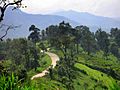
Many other beautiful national parks are also found here. These include Doi Suthep-Pui, Ob Luang, and Sri Lanna. You can also find Huai Nam Dang, Mae Wang, and Pha Daeng in the province.
Chiang Mai's Past

The city of Chiang Mai was once the capital of the Lanna Kingdom. It was founded in the year 1296.
Later, in 1599, the Lanna Kingdom became part of the Ayutthaya Kingdom. This meant it was no longer an independent kingdom.
In 1932, Chiang Mai Province became a major part of Thailand. This happened when the old administrative area, called Monthon Phayap, which was the last part of the Lanna Kingdom, was officially ended.
People and Cultures

About 13.4% of the people living in Chiang Mai Province are members of hill tribes. These groups have their own unique cultures and traditions.
Some of the hill tribes you might find here include the Hmong, Yao, and Lahu. Other tribes are the Lisu, Akha, and Karen.
Weather in Chiang Mai
Chiang Mai has a warm climate all year round. It experiences a "tropical wet and dry climate." This means it has a rainy season and a dry season.
Even though it's warm, nights during the dry season can be much cooler than the daytime. The hottest temperature ever recorded was 42.4 degrees Celsius (108.3 degrees Fahrenheit) in May 2005.
Getting Around Chiang Mai


There are many ways to travel in and around Chiang Mai:
- Car: Chiang Mai is connected by Highway 11, also known as Super Highway Road.
- Train: The city is the final stop for the northern railway line.
- Songthaew: These are red pickup trucks with two rows of seats in the back. They act like shared taxis.
- Samlor: These are traditional rickshaws, often found in the city center for short rides.
- Tuk-tuks: These are small, three-wheeled auto rickshaws. They are good for quick trips.
- Buses: You can take buses to Chiang Mai from Bangkok and many other cities.
- Bicycle and Motorbike: You can rent bikes and motorbikes in Chiang Mai city to explore on your own.
- Air: Chiang Mai International Airport (CNX) is one of Thailand's international airports.
Images for kids
-
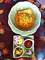
Khao soi, a popular local dish
-
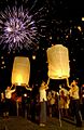
Chiang Mai during the Yi Peng Festival
-
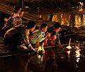
People floating krathong rafts during the Loi Krathong festival in Chiang Mai
-

Thaksin Shinawatra with Vladimir Putin at APEC Thailand 2003. Thaksin was born in San Kamphaeng District.
-

The viewpoint at the 41st km of Highway 1009, Doi Inthanon
-

Prunus cerasoides (Wild Himalayan Cherry) blooming at Doi Suthep–Pui National Park
-

Pong Dueat Hot Springs, Huai Nam Dang National Park
-
Ob Khan National Park
-
Mae Wang National Park
-

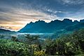
Doi Chiang Dao mountain
-

Pha Daeng National Park in Chiang Dao District
-
The mountains of Chiang Dao Wildlife Sanctuary in Chiang Dao District
-
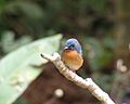
A photo of a hill blue flycatcher in the Chiang Dao Wildlife Sanctuary
-
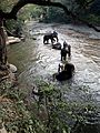
Bathing elephants in the Taeng River
-
Mae Thun Noi, Omkoi
-
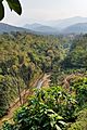
The Fang River, part of the Mekong watershed, in Chai Prakan District
-
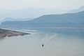
The lake of Mae Ngat Somboon Chon Dam, Si Lanna National Park
-
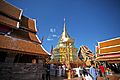
Wat Phra That Doi Suthep
-
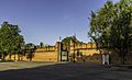
East gate (Tha Phae Gate) of the city wall
-

A shopping mall in Chiang Mai
-
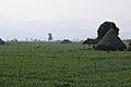
Thaton countryside
-
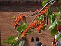
The "flame of the forest" tree


See also
 In Spanish: Provincia de Chiang Mai para niños
