Tamarindo, Costa Rica facts for kids
Quick facts for kids
Tamarindo
|
|
|---|---|
|
District
|
|

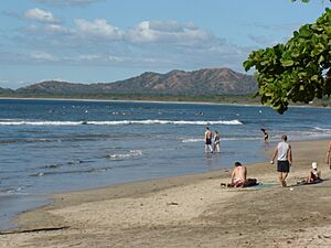
The coastline in Tamarindo
|
|
| Country | |
| Province | Guanacaste |
| Canton | Santa Cruz |
| Creation | 27 November 1995 |
| Area | |
| • Total | 125.86 km2 (48.59 sq mi) |
| Elevation | 27 m (89 ft) |
| Population
(2011)
|
|
| • Total | 6,375 |
| • Density | 50.652/km2 (131.187/sq mi) |
| Time zone | UTC−06:00 |
| Postal code |
50309
|
Tamarindo is a lively district in the Guanacaste region of Costa Rica. It is located on the Nicoya Peninsula, a beautiful area known for its beaches.
Once a quiet fishing village, Tamarindo has grown a lot. It is now a popular spot for surfing and eco-tourism. Many people who love surfing, or who work online, choose to live here.
Contents
History of Tamarindo
Tamarindo started as a small village where families mostly depended on fishing for their living.
How Tourism Started
In 1985, a businessman named Russell Wenrich bought land in Tamarindo. He began building small beach cabins for visitors. Five years later, he met Robert August, a famous surfer from the 1966 movie The Endless Summer. Robert August moved to Tamarindo.
Later, Wenrich convinced the Costa Rican tourism agency to help film the movie's sequel, The Endless Summer II, in Tamarindo. This movie, which showed scenes from Tamarindo, helped the town become a popular tourist spot. It changed from a small fishing village into the busy place it is today.
Tamarindo officially became a town on November 27, 1995. This was made possible by a special government order.
Growth and Challenges
A big change happened in 2003 when the nearby airport in Liberia started having international flights. This made it much easier for people from other countries to visit Tamarindo.
Over the years, Tamarindo has worked hard to keep its beaches clean. The town aims to earn a special award called the Blue Flag designation. This award shows that a beach meets high standards for cleanliness and safety. After a lot of effort, Tamarindo reportedly regained this award in 2018.
Exploring Tamarindo's Geography
Tamarindo covers an area of about 125.86 square kilometers (48.59 sq mi). It is located at an elevation of 27 meters (89 feet) above sea level.
Nearby Towns and Villages
Besides Tamarindo itself, other towns in the district include Villarreal, Santa Rosa, Garita Nueva, Hernández, Hucus, Flamingo, and San José de Pinilla.
Villarreal: A Local Hub
The nearby town of Villarreal is an important place for locals. It has public schools, soccer fields, restaurants, and stores. You can also find hardware stores, a police station, a church, and car repair shops there.
Langosta: A Quiet Beach Area
Just east of central Tamarindo, a road leads to Playa Langosta. This area offers another beautiful beach experience.
Playa Grande: A Neighbor to the North
To the north of Tamarindo is Playa Grande. You can usually reach it by taking a small boat across the marine park estuary. Or, you can drive about 17 kilometers (11 miles) through Villarreal.
Fun Activities in Tamarindo
Tamarindo is a great place for many outdoor activities and adventures.
Beautiful Beaches
The beaches in the Tamarindo area are generally clean. The government and local businesses have been working hard to keep them that way. Even though the beach has not always had its Blue Flag Status, it has received good reports on its cleanliness from the Costa Rican government.
Surfing Adventures
Tamarindo and the areas nearby are very popular for surfing. You can find waves suitable for all skill levels, from beginners to advanced surfers.
Exciting Fishing Trips
Tamarindo is known for its excellent fishing opportunities. Many captains and charter services are available to take you out on the water. If you want to fish, Costa Rica requires a fishing license.
Scuba Diving Wonders
The Catalinas Islands are a top spot for scuba diving. Divers love this area because of the wide variety of sea creatures and amazing underwater views.
Golfing Fun
If you enjoy golf, there are several courses nearby. These include the Hacienda Pinilla Golf Club and the Reserva Conchal Beach Resort.
Culture and Arts Scene
Tamarindo has a lively cultural scene. You can find a night market, a food truck park, and a skate park. There are also regular fire shows on the beach.
The town hosts several music festivals, including The BPM Festival and the Ocaso Underground Music Festival.
Tamarindo's Weather
Tamarindo has two main seasons. The wet season usually runs from May to November. The dry season is from December to April.
Population Growth
| Historical population | |||
|---|---|---|---|
| Census | Pop. | %± | |
| 2000 | 3,525 | — | |
| 2011 | 6,375 | 80.9% | |
|
Instituto Nacional de Estadística y Censos |
|||
Tamarindo's population has been growing. In the 2011 census, about 6,375 people lived there. By the 2020 census, the population had grown to 7,861.
Getting Around Tamarindo
Tamarindo is easy to reach by different types of transportation.
Road Travel
The district is served by two main roads:
Air Travel
Tamarindo is the most accessible place along the northern Pacific coast of Costa Rica because it has its own airstrip.
The closest international airport is Liberia International Airport. It is about an hour's drive from Tamarindo.
Public Transport
There is a bus service that runs daily to and from San José, the capital city. The drive to San José takes about 3.5 to 6 hours, depending on traffic.
Images for kids
See also
 In Spanish: Tamarindo (Costa Rica) para niños
 | Charles R. Drew |
 | Benjamin Banneker |
 | Jane C. Wright |
 | Roger Arliner Young |


