Tampa, Colorado facts for kids
Quick facts for kids
Tampa
|
|
|---|---|
| Country | United States |
| State | Colorado |
| County | Weld |
| Time zone | UTC-7 (Mountain (MST)) |
| • Summer (DST) | UTC-6 (MDT) |
| ZIP codes |
80643
|
Tampa is a small place in Weld County, Colorado, United States. It is called an unincorporated community. This means it is a group of homes and businesses that is not officially a town or city. The people living there get their mail using the 80643 ZIP code.
Contents
Tampa's Railroad History
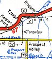
Long ago, Tampa was an important spot for an old train track. This track was called the Tampa Spur. It was part of a bigger train line, the CB&Q, which is now known as BNSF. Tampa was located between the towns of Roggen and Keenesburg.
The Tampa Spur
The Tampa Spur was a short train track, about 1.5 miles long. It connected Tampa to a place called Sheehan, near Prospect Valley. This spur was built in 1882. Its main job was to help farmers. It worked as a "sugar beet dump."
A sugar beet dump was a special elevated place. Farmers could drive their trucks up to it. Then, they would dump their freshly harvested sugar beets directly into open train cars below. This made it easy to transport the beets. The Tampa Spur was still on train maps in 1983. However, you won't find it on today's maps.
Modern Day Rail Facilities
In 2013, a company called Plains All American Pipeline built new train facilities in Tampa. These facilities cost about $125 million to build. They are located about 50 miles northeast of Denver.
How the Facility Works
The Tampa facility is designed to handle crude oil. Crude oil is oil that comes straight from the ground. Trucks and pipelines bring the oil to the facility. Then, the oil is loaded onto special trains. These trains can carry up to 68,000 barrels of oil each day.
The facility helps transport oil from the DJ Basin. This is an area where a lot of oil is produced. The BNSF Railway Company helps move the trains from the facility.
Geography
Tampa is located at coordinates 40.149982 degrees north and 104.455512 degrees west. This is about 5.5 miles northeast of Keenesburg. The land in Tampa is about 4,813 feet above sea level. Interstate 76 runs right next to the community.
Images for kids


