Tanner Creek (Columbia River tributary) facts for kids
Quick facts for kids Tanner Creek |
|
|---|---|
|
Location of the mouth of Tanner Creek in Oregon
|
|
| Country | United States |
| State | Oregon |
| County | Multnomah County |
| Physical characteristics | |
| Main source | Tanner Butte 3,710 feet (1,130 m) 45°32′44″N 121°57′39″W / 45.54556°N 121.96083°W |
| River mouth | Columbia River west of Bonneville Dam Oregon 20 feet (6.1 m) 45°37′57″N 121°57′39″W / 45.63250°N 121.96083°W |
| Basin features | |
| Progression | Tanner Creek → Columbia River → Pacific Ocean |
Tanner Creek is a cool stream in Oregon. It flows through the amazing Columbia River Gorge. This creek is about 6 miles (10 km) long. It starts near Tanner Butte, which is the highest point in this part of the Gorge. The creek then flows into the big Columbia River, close to the Bonneville Dam.
Contents
Exploring Tanner Creek
Tanner Creek is a fun place to visit. It has a famous waterfall and trails for hiking. The area is known for its beautiful nature.
Wahclella Falls: A Stunning Waterfall
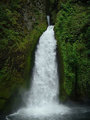
The most exciting part of Tanner Creek is Wahclella Falls. This waterfall is super tall, about 350 feet (107 meters) high! It's located about 1.5 miles (2.4 km) from where the creek meets the Columbia River.

Many people love to visit Wahclella Falls. There's a special path called the Wahclella Falls Trail #436. This trail is about 2.4 miles (3.9 km) long. It starts from the Historic Columbia River Highway State Trail and leads right to the falls.
Hiking Trails Along the Creek
Further up the creek, you can find the Tanner Creek Trail #431. This trail is more remote, meaning fewer people use it. It follows the creek from the end of a closed road.
You can connect to other trails from here. These include the Tanner Cutoff Trail #448 and the Moffett Creek Trail #430. These connections help link this area to the wider network of trails in the Gorge.
Impact of the Eagle Creek Fire
In 2017, a big wildfire called the Eagle Creek Fire happened. It caused a lot of damage to the Tanner Creek area. A large part of the canyon was severely burned.
Because of the fire, there's a higher risk of landslides and mudslides. These are dangerous, so the area has been closed for safety. As of January 2019, it was still closed to visitors. This helps keep everyone safe while the area recovers.
 | Isaac Myers |
 | D. Hamilton Jackson |
 | A. Philip Randolph |


