Wahclella Falls facts for kids
Quick facts for kids Wahclella Falls |
|
|---|---|

Wahclella Falls
|
|
| Lua error in Module:Infobox_mapframe at line 185: attempt to index field 'wikibase' (a nil value). | |
| Location | Columbia River Gorge, Multnomah County, Oregon, United States |
| Coordinates | 45°37′4.5″N 121°56′59.7″W / 45.617917°N 121.949917°W |
| Type | Tiered |
| Total height | 350 ft (107 m) |
| Number of drops | 2 |
| Longest drop | 60 ft (18 m) |
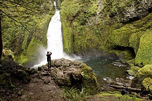
Wahclella Falls is a beautiful waterfall in Oregon, a state in the United States. It's located in the amazing Columbia River Gorge. This waterfall is part of Tanner Creek, which flows into the mighty Columbia River.
Contents
Visiting Wahclella Falls
Wahclella Falls is a popular spot for hikers. You can find it near exit 40 on the Columbia River Highway. This exit also leads to the Bonneville Dam.
How to Get There
The parking area for Wahclella Falls is easy to find. If you are driving east, it's just past the entrance to the Bonneville Dam. Look for a small road going downhill to your right.
The Hiking Trail
A well-kept trail, number 436, takes you to the falls. This trail is a loop, meaning it circles back to where you started. The entire trip is about 1.8 miles (2.9 km) long. Wahclella Falls is located right in the middle of this scenic loop.
About the Waterfall
Wahclella Falls is made up of two main parts, or segments. The total height of both parts combined is about 350 feet (107 meters).
Upper and Lower Falls
The upper part of the waterfall is not fully visible from the trail. However, the lower part is completely in view. This lower section is about 60 feet (18 meters) tall. It crashes down from a narrow canyon carved into dark gray rock.
The Plunge Pool
At the bottom of the falls, there is a pool of water called a plunge pool. This area looks very pretty because of the natural rock walls around it. These walls form a half-circle shape, like a natural theater.
Water Flow Through the Year
Like most waterfalls, the amount of water flowing over Wahclella Falls changes with the seasons. However, Tanner Creek, which feeds the falls, gets most of its water from an underground spring. This means the water flow is usually steady and not greatly affected by bad weather.
History and Naming
Wahclella Falls got its name from a nearby village of Native Americans. The Mazama mountaineering club gave it this name in 1915.
Official and Other Names
Even though Wahclella Falls is its official name, the United States Geological Survey still calls it Tanner Creek Falls. This shows that waterfalls can sometimes have more than one name!
Parking Information
The United States Forest Service manages the area around the falls. They charge a small fee for parking at the trailhead. You might also need a special pass to park there.
 | Ernest Everett Just |
 | Mary Jackson |
 | Emmett Chappelle |
 | Marie Maynard Daly |

