
Tanner Graben facts for kids
Quick facts for kids Tanner Graben |
|
|---|---|

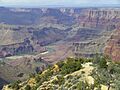
View north, upriver, Temple and Chuar Buttes, on west bank of Colorado River, East Rim to photo right, and extending to center, top. Black Cardenas Basalt of Tanner Graben, at photo bottom-left, with layered Nankoweap Formation at Tanner Graben prominence. (Mile 68.5, Colorado River)
|
|
| Highest point | |
| Elevation | 4,200 ft (1,300 m) —Lava Butte (Grand Canyon), 4,242 feet (1,293 m) |
| Geography | |

Tanner_Graben
Location in Arizona
|
|
| Location | Grand Canyon, Colorado River, Mile 68.5, Desert View, (East Rim) |
| Settlement | Desert View, Arizona |
| Geology | |
| Mountain type | Nankoweap Formation-(prominence), Cardenas Basalt & Dox Formation |
The Tanner Graben is a cool rock formation in the Grand Canyon, Arizona, USA. It's a tall cliff near where the Little Colorado River joins the main Colorado River. You can find it right next to the Colorado River, about 68.5 miles downstream from a famous spot. It's across from Tanner Canyon. A fast part of the river, called Tanner Rapid, is right at the bottom of the graben.
The Tanner Graben stands out because of its dark, black rock called Cardenas Basalt. This rock forms the middle part of the graben. The cliff face is very steep, so wind and river currents keep it clear of loose rocks and dirt. Other places with Cardenas Basalt often have piles of debris, but the Tanner Graben stays clean and black.
The Tanner Graben sits on top of something called the Butte Fault. A fault is like a big crack in the Earth's crust where rocks have moved. This fault runs north and south along the Colorado River. The Butte Fault is also connected to the East Kaibab Monocline, which is another large bend in the rock layers.

Contents
What is the Geology of Tanner Graben?
The south side of the Tanner Graben shows three different types of rock layers. These layers are part of the Grand Canyon Supergroup, which is a very old set of rocks. They are tilted at an angle of about 15 degrees.
The top part of the graben is made of a distinct, layered rock called Nankoweap Formation. This is the second main unit of the Grand Canyon Supergroup. Below the Nankoweap Formation are older rocks from the Unkar Group, which is the first and lowest group of the Supergroup.
A lot of the Tanner Graben is made of the black Cardenas Basalt. This rock is unit 5 of the Unkar Group. Underneath the Cardenas Basalt is a softer, reddish, and layered rock called Dox Formation. The Dox Formation forms the sides of the graben and shows how much the rock has moved down along the fault.
How Can You See Tanner Graben?
You can get great views of the Tanner Graben from the Tanner Trail. This trail goes down the west side of Tanner Canyon. The trail starts from Desert View, which is on the East Rim of the Grand Canyon. Many viewpoints along the East Rim also look down towards the Tanner Graben. The Tanner Graben is about 1.5 miles west of Comanche Point. Comanche Point is about 3 miles north of Desert View.
What are the Grand Canyon Supergroup Rocks?
The Grand Canyon Supergroup is a collection of very old rock layers found in the Grand Canyon. Here are the main units, from youngest to oldest:
- 4--Sixtymile Formation
- 3--Chuar Group
- Kwagunt Formation
- Galeros Formation
- 2--Nankoweap Formation
- 1--Unkar Group
- 5--Cardenas Basalt, the youngest part of the Unkar Group, formed about 1070 million years ago.
- 4--Dox Formation
- 3--Shinumo Quartzite
- 2--Hakatai Shale
- 1--Bass Formation
Images for kids
-

View from Comanche Point. Tanner Rapid and Tanner Graben, photo, bottom-left, showing 1-southeast cliff-face, 2-northeast side, and 3-upper surface of graben.
-
View upriver from Tanner Trail-region (west ridgeline of Tanner Canyon, Desert View, East Rim) (black graben, center-edge, photo left)


