
Nankoweap Formation facts for kids
Quick facts for kids Nankoweap FormationStratigraphic range: Neoproterozoic, <770 Ma |
|
|---|---|

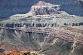
Venus Temple landform, NNW of Lipan Point (East Rim); tilted (striped & multilayered) Nankoweap Formation above tilted (blackish) Cardenas Basalt, above (tilted and reddish) Dox Formation.
|
|
| Type | Geological formation |
| Unit of | Grand Canyon Supergroup |
| Underlies | Chuar Group and, as part of the Great Unconformity, the Tapeats Sandstone |
| Overlies | Cardenas Basalt |
| Thickness | 370 feet (110 m) approximate maximum |
| Lithology | |
| Primary | sandstone, siltstone & shale (red beds) |
| Location | |
| Region | Arizona east Grand Canyon Lava Butte region on Colorado River, near Lipan Point |
| Country | United States (Southwestern United States) |
| Extent | (eastern) Grand Canyon, Colorado River region |
| Type section | |
| Named for | Nankoweap Canyon |
| Named by | Van Gundy (1934), Van Gundy (1951), and Maxson (1961) |
The Nankoweap Formation (say: Nan' coe weep) is a special layer of reddish rocks found in the Grand Canyon. It's part of the Grand Canyon Supergroup, which is a very old collection of rock layers. This formation is made mostly of reddish-brown and tan sandstone, along with some siltstone and mudrock.
The Nankoweap Formation sits on top of older basalt lava flows called the Cardenas Basalt. It is also found beneath the Galeros Formation, which is part of the Chuar Group. The Nankoweap Formation is about 100 meters (330 feet) thick. It's divided into two main parts: a lower section and an upper section. These sections are separated by gaps in time where rocks were eroded away.
You can see the Nankoweap Formation in a small part of the eastern Grand Canyon, near the Colorado River. The best places to see it are around Basalt Canyon, Comanche Creek, and Tanner Canyon.
Contents
How the Nankoweap Formation Got Its Name
The name "Nankoweap Formation" comes from Nankoweap Canyon, where a small piece of this rock layer is found.
At first, scientists thought these rocks were part of other groups. In 1894, a scientist named Walcott included parts of the Nankoweap rocks in the "Unkar terrane" and "Chuar terrane."
Later, in the 1930s and 1950s, a scientist named Van Gundy realized that these thin, reddish layers were different. He saw that they rested on top of the basalt lava flows of the Unkar Group. He decided they should be their own separate rock unit and called it the "Nankoweap Group."
Even later, a scientist named Maxson changed the name from "Group" to "Formation." This is because a "Group" usually has smaller "Formations" inside it, but the Nankoweap hadn't been split into smaller parts. Scientists also found a lower, iron-rich layer that sits on the Cardenas Basalt and is covered by the upper part of the Nankoweap.
What the Nankoweap Formation Looks Like
The Nankoweap Formation is a little over 100 meters (330 feet) thick. It has two main parts: a lower, iron-rich part and an upper part. These parts are separated by surfaces where erosion happened.
The Lower Part
The lower, iron-rich part of the Nankoweap Formation is thin, usually 15 meters (50 feet) thick or less. It's made of pieces that are left over after erosion. This part sits on top of the Cardenas Basalt lava flows, which were deeply eroded and weathered.
You can only see this lower part in two places in the Grand Canyon. One spot is north of the Colorado River, near Tanner Canyon Rapids. Here, the lower part is made of strong, red sandstone and siltstone that are cemented together with hematite (an iron mineral). It's about 15 meters thick. The other spot is south of the Colorado River. Here, it's a thin layer of iron-rich sandstone, along with a 10-meter (33-foot) thick layer of ancient soil (called a paleosol) that formed on the eroded Cardenas Basalt.
The Upper Part
The upper part of the Nankoweap Formation is about 100 meters (330 feet) thick. It's mostly reddish-purple, fine-grained sandstone. Near the top, it becomes more shaley and silty.
Sometimes, these sandstones have layers with rounded, disc-shaped pebbles from the Dox Sandstone and even some basalt lava pebbles. At the very bottom of the upper part, you might find a layer of gravel made of white or yellowish chert pebbles.
The sandstone layers usually look thin to medium-sized. They often show features like:
- Cross-bedding: Slanted layers that show how sand was moved by water or wind.
- Ripple marks: Wavy patterns like those you see on a sandy beach.
- Mudcracks: Cracks formed when wet mud dried out.
- Soft-sediment deformation structures: Signs that the mud was squishy and moved around before it hardened.
- Salt pseudomorphs: Shapes left behind by salt crystals that dissolved away.
Towards the top of the upper part, you'll find thicker, more solid sandstone beds.
How the Rock Layers Connect
The Nankoweap Formation has special boundaries called "unconformities" at its bottom and possibly its top. An unconformity is like a missing page in a history book – it means there was a long time when rocks were eroded away instead of being deposited.
The Nankoweap Formation sits on top of the Cardenas Basalt. In most places, the upper part of the Nankoweap Formation rests directly on the Cardenas Basalt. In Basalt Canyon, the layers below are tilted differently, showing that 60 meters (200 feet) of Cardenas Basalt were eroded before the Nankoweap was laid down. West of Tanner Canyon, as much as 300 meters (980 feet) of Cardenas Basalt were eroded!
Before the Nankoweap Formation was deposited, the Cardenas Basalt lava flows were exposed to the air and deeply weathered. This created a 10-meter (33-foot) thick layer of ancient soil (paleosol) that was rich in iron.
The top of the Nankoweap Formation meets the Galeros Formation (part of the Chuar Group) very sharply. The top of the Nankoweap is made of sandstones that change color from red to white. Scientists think this color change happened because the rocks were bleached beneath an unconformity. This contact is hard to reach because it's in the middle of tall cliffs.
The contact between the Nankoweap Formation and the much younger Tapeats Sandstone is a very clear angular unconformity. This means the Nankoweap rocks were tilted and faulted, and then the flat Tapeats Sandstone was laid on top. This big gap in time is part of the famous Great Unconformity in the Grand Canyon.
Scientists have studied tiny crystals called zircons from the Nankoweap Formation. These crystals tell us that the Nankoweap Formation is about 800 to 770 million years old. This means it's very close in age to the Chuar Group, and it might even be the very bottom layer of that group.
Where the Rocks Formed
Scientists are still trying to figure out exactly how and where the Nankoweap Formation rocks were deposited.
The ancient soil found on the Cardenas Basalt shows that there was a long time when the land was exposed to the air and weathered before the Nankoweap rocks were laid down. The sandstones in the lower part also seem to have formed on land.
The features in the upper part of the Nankoweap Formation, like ripple marks and cross-bedding, suggest that these rocks formed in shallow water, possibly a shallow sea or a lake. Some layers in the upper part might have formed in sand and mudflats, or even as beach deposits.
Ancient Life in the Nankoweap Formation
Scientists have found some interesting things in the Nankoweap Formation that might be signs of ancient life!
A scientist named Van Gundy found a strange shape in a sandstone bed in Basalt Canyon. It was about 12 cm (5 inches) wide and looked like a stranded jellyfish. It had radiating lobes (parts spreading out) and a small hollow in the middle.
At first, other scientists also thought it was a jellyfish and even gave it a scientific name: “Brooksella canyonensis.”
However, later studies questioned this. One scientist, Cloud, thought it was just an inorganic structure, maybe formed by sand settling over a gas bubble. But other paleontologists (scientists who study fossils) disagreed. They thought it was a trace fossil – a sign of ancient life, like a burrow made by a worm-like creature. They called it “Asterosoma.”
Even later, more scientists looked at these shapes again. They now believe these structures are not fossils at all! They think they are inorganic sedimentary structures, like small "sand-volcanoes." These can form when gas or fluid escapes from wet sand as more sediment piles on top, or when the ground shakes during an earthquake. These structures are very similar to other features that were once thought to be fossil jellyfish but are now known to be formed by sand venting through microbial mats (layers of tiny living things) on ancient sea or lake bottoms.
Age of the Nankoweap Formation
The Nankoweap Formation hasn't been directly dated using special age-finding techniques. But we know it's younger than the Cardenas Basalt, which formed about 1,104 million years ago.
Scientists used to think the Nankoweap Formation was older than the Chuar Group (which is 800 to 740 million years old). However, by studying tiny zircon crystals found in the Nankoweap Formation, scientists found that these crystals are about 800 to 770 million years old. This means the Nankoweap Formation itself must be younger than 770 million years. This discovery shows that the Nankoweap Formation is very close in age to the Chuar Group, and it's likely the very first layer of that group.
Barite Deposits
In Nankoweap Canyon, people have dug small prospect pits into patches of sandstone that have been replaced by a red iron mineral called hematite. In these pits, they found sandstone cemented with barite (a heavy mineral) and thin veins of barite. Some of these patches are quite large, over 10 feet wide. The sandstones around these barite deposits are often bent and broken by small faults.

Nankoweap Creek and Tanner Graben
Nankoweap Creek is a stream located upstream from Lipan Point. It flows into the Grand Canyon near Lower Marble Canyon.
The Tanner Graben is a section of rock that has dropped down between two faults. It's made of Dox Formation and Cardenas Basalt rocks, and on top of it sits a bright, layered section of the Nankoweap Formation. The Tanner Graben is across from Tanner Creek (Tanner Canyon), which is where the Tanner Rapid in the Colorado River gets its name.
Images for kids
-
Close-up of Apollo Temple

