
Chuar Butte facts for kids
Quick facts for kids Chuar Butte |
|
|---|---|

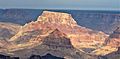
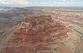
Aerial view looking northeast
|
|
| Highest point | |
| Elevation | 6,500 ft (2,000 m) |
| Prominence | 1,513 ft (461 m) |
| Isolation | 2.95 mi (4.75 km) |
| Parent peak | Gunther Castle (7,199 ft) |
| Geography | |

Chuar Butte
Location in Arizona

Chuar Butte
Location in the United States
|
|
| Location | Grand Canyon National Park Coconino County, Arizona, US |
| Parent range | Kaibab Plateau Colorado Plateau |
| Topo map | USGS Cape Solitude |
| Type of rock | sandstone, siltstone, limestone |
| Climbing | |
| Easiest route | class 5.2 climbing |
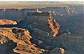
Chuar Butte is a tall mountain peak, about 6,500 feet (1,981 meters) high, located in the amazing Grand Canyon. You can find it in Coconino County, in northern Arizona, USA.
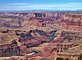
This butte stands about 1.5 miles northwest of Cape Solitude, which is on the eastern edge of the canyon. It's also three miles southeast of Gunther Castle. Chuar Butte is right where the Colorado River and Little Colorado River meet. This spot is also where Marble Canyon ends and the main Grand Canyon begins.
The land around Chuar Butte rises very steeply. It goes up almost 3,800 feet (1,160 meters) from the river in less than a mile! The climate here is a Cold semi-arid climate zone, which means it's usually dry and can have cold winters.
Contents
History of Chuar Butte
How Chuar Butte Got Its Name
Chuar Butte was named by a famous explorer named John Wesley Powell. He named it after Chuarrumpeak, or Chuar-ru-um-pik. This was a young chief from the Kaibabits tribe who helped Powell on his expeditions. People often called him "Chuar" for short. Another name for this butte is Chuarooum Peak. The name "Chuar Butte" was officially recognized in 1906 by the United States Board on Geographic Names.
Important Event Near Chuar Butte
Chuar Butte and a nearby peak called Temple Butte are known for a sad event that happened in 1956. Two large passenger planes had an accident in the air above this area. This terrible event led to a big change in how air travel was managed in the United States. It made the government create the Federal Aviation Administration (FAA). The FAA's job is to make sure flying is safe for everyone.
Because of its importance to air safety history, this site was named a National Historic Landmark on April 22, 2014. It's in a very remote part of the canyon, so only hikers can reach it.
Geology of Chuar Butte
Understanding the Rock Layers
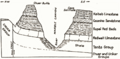
The very top of Chuar Butte is made of a type of rock called Permian Kaibab Limestone. Limestone is a rock often formed from the shells and skeletons of sea creatures.
Below the Kaibab Limestone, you'll find a cream-colored rock that forms steep cliffs. This is the Permian Coconino Sandstone. Sandstone is made from tiny grains of sand pressed together over millions of years. This sandstone is one of the younger rock layers in the Grand Canyon. It was formed about 265 million years ago from ancient sand dunes.
Deeper Rock Formations
Underneath the Coconino Sandstone is a reddish, sloped layer called the Permian Hermit Formation. Below that, you'll find the Pennsylvanian-Permian Supai Group.
Even further down are layers of Mississippian Redwall Limestone. This limestone often looks red because of iron minerals. Finally, at the level of the river, you can see the Cambrian Tonto Group.
There's also a special feature called the Butte Fault on the western side of Chuar Butte. A fault is a crack in the Earth's crust where rocks have moved. Because of this fault, some very old rock layers, like the Neoproterozoic Chuar Group, have been pushed up. This has exposed mudstone from the Chuar Group, which is a type of rock made from hardened mud.
Gallery
-
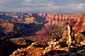
Chuar Butte illuminated, with Temple Butte below
-
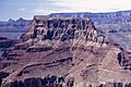
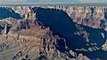
Chuar Butte from north rim of Little Colorado River
-
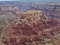
Aerial view looking north
-
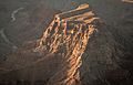
Aerial view looking south
-
Aerial view looking north
-
Chuar Butte centered at top, view from Desert View
-
Chuar Butte (shaded) behind Temple Butte
-
Chuar Butte left of center in the distance, seen from Desert View
-


Images for kids
-
Aerial view looking northeast
-
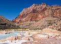
Chuar Butte with Little Colorado River

