
Gunther Castle facts for kids
Quick facts for kids Gunther Castle |
|
|---|---|

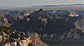
South aspect, aerial view
|
|
| Highest point | |
| Elevation | 7,199 ft (2,194 m) |
| Prominence | 1,019 ft (311 m) |
| Isolation | 1.41 mi (2.27 km) |
| Parent peak | Butchart Butte (7,602 ft) |
| Geography | |

Gunther Castle
Location in Arizona

Gunther Castle
Location in the United States
|
|
| Location | Grand Canyon National Park Coconino County, Arizona, US |
| Parent range | Kaibab Plateau Colorado Plateau |
| Topo map | USGS Cape Solitude |
| Type of rock | sandstone, siltstone, limestone |
| Climbing | |
| First ascent | 1969 |
Gunther Castle is a tall mountain peak in the Grand Canyon, located in northern Arizona, USA. It stands 7,199 feet (2,194 meters) high. This impressive summit is found in Coconino County, a part of Arizona.
The peak is about three miles northwest of Chuar Butte. It sits between Kwagunt Valley to the north and Chuar Valley to the south. Gunther Castle rises almost 4,500 feet (1,370 meters) above the Colorado River in just three miles. This means it has a very steep and dramatic rise from the river below.
About the Name
Gunther Castle gets its name from Gunther, a legendary king. He was a historical king of Burgundy, a kingdom from long ago. Gunther is also a famous figure in Germanic mythology, which are old stories and legends from Germanic peoples.
The name "Gunther Castle" was officially chosen in 1906. It was adopted by the United States Board on Geographic Names. This board is responsible for naming natural features across the United States.
Geology and Climate
The very top part of Gunther Castle is made of different rock layers. These layers are from the Pennsylvanian and Permian periods. They belong to a rock formation called the Supai Group.
Below these layers, you can see a clear cliff made of Mississippian Redwall Limestone. Underneath that, there is a layer of shale from the Cambrian period. This shale is part of the Tonto Group.
Gunther Castle is in a Cold semi-arid climate zone. This means it gets some rain, but it's generally dry and cool. Any rain that falls on Gunther Castle flows east. It drains into the nearby Colorado River through two creeks: Chuar Creek and Kwagunt Creek.
First Climbers
The first recorded climb to the top of Gunther Castle happened in June 1969. A team of four climbers made this challenging ascent. The team included Alan Doty, Doc Ellis, Donald Davis, and Harvey Butchart.
However, they were not the very first people to stand on the summit. When they reached the top, they found something interesting. They discovered a wooden marker and a large coil of unused wire. This showed that land surveyors had been there before them. It seems the surveyors likely arrived by helicopter.
Images for kids
-
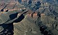
Gunther Castle from Cape Final
-
Gunther centered, aerial view looking northwest. Butchart Butte upper left.


