
Butchart Butte facts for kids
Quick facts for kids Butchart Butte |
|
|---|---|

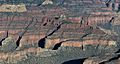
Butchart Butte, south aspect
|
|
| Highest point | |
| Elevation | 7,602 ft (2,317 m) |
| Prominence | 542 ft (165 m) |
| Isolation | 0.80 mi (1.29 km) |
| Parent peak | Siegfried Pyre (7,922 ft) |
| Naming | |
| Etymology | Harvey Butchart |
| Geography | |

Butchart Butte
Location in Arizona

Butchart Butte
Location in the United States
|
|
| Location | Grand Canyon National Park Coconino County, Arizona, US |
| Parent range | Kaibab Plateau Colorado Plateau |
| Topo map | USGS Walhalla Plateau |
| Type of rock | sandstone, limestone, mudstone |
| Climbing | |
| Easiest route | class 5.1 climbing |
Butchart Butte is a tall mountain peak in the amazing Grand Canyon. It stands 7,602-foot (2,317 m) (about 2,317 meters) high. You can find it in Coconino County, in northern Arizona, United States. This butte is on the North Rim of the Grand Canyon. It sits between two other cool spots, Gunther Castle and Siegfried Pyre. It also lies between the Chuar and Kwagunt Valleys. Butchart Butte rises very steeply, about 4,900 feet (1,500 m) (1,494 meters) above the Colorado River in just five miles!
Why is it Called Butchart Butte?
This special butte is named after Dr. John Harvey Butchart. He was a mathematics professor and a famous explorer. Dr. Butchart was known for his amazing hiking and climbing adventures in the Grand Canyon.
He climbed 83 different peaks inside the canyon. He was also the first person to climb 28 of them! This is a record no one else has matched. The name "Butchart Butte" was officially chosen in 2009. This was done by the United States Board on Geographic Names.
A fellow explorer, Jim Haggart, suggested the name. Even though Dr. Butchart climbed a nearby peak called Siegfried Pyre, he never actually climbed Butchart Butte itself.
What is Butchart Butte Made Of?
Butchart Butte is made up of different layers of rock. The very top part is mostly Permian Coconino Sandstone. Below that are layers from the Pennsylvanian and Permian periods, called the Supai Group.
Underneath these layers is a thick cliff-forming rock called Mississippian Redwall Limestone. Below that, you'll find the Cambrian Tonto Group. Finally, at the very bottom, near the river, are rocks from the Neoproterozoic Chuar Group.
Climate and Water
Butchart Butte is in a Cold semi-arid climate zone. This means it's usually dry, but it can get cold. When it rains, the water flows off the butte. This runoff goes into nearby creeks. These creeks, like Chuar Creek and Kwagunt Creek, then flow into the Colorado River.
Gallery
-
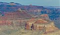
Butchart Butte centered at top, South aspect, aerial view.
-
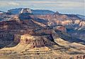
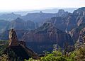
Butchart Butte in upper right. Also in the frame are Apollo Temple, Jupiter Temple, and Siegfried Pyre.
-
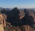
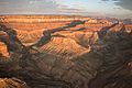
Siegfried Pyre centered with Butchart Butte to right. From Cape Final.
-
Aerial looking southwest at Siegfried Pyre (centered) and Butchart Butte (lower left)
-
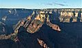
Butchart Butte centered in back, looking southeast from Point Imperial. Also in the field of view: Mount Hayden, Colter Butte, Alsap Butte, and Siegfried Pyre.
-
Aerial view looking west, Butchart in bullseye
-
Butchart Butte in upper right


.jpg)
