Siegfried Pyre facts for kids
Quick facts for kids Siegfried Pyre |
|
|---|---|
 |
|
| Highest point | |
| Elevation | 7,922 ft (2,415 m) |
| Prominence | 832 ft (254 m) |
| Isolation | 4.43 mi (7.13 km) |
| Parent peak | Brady Peak |
| Geography | |
| Location | Grand Canyon National Park Coconino County, Arizona, US |
| Parent range | Kaibab Plateau (Walhalla Plateau) Colorado Plateau |
| Topo map | USGS Walhalla Plateau |
| Geology | |
| Age of rock | Permian down to Cambrian |
| Mountain type | sedimentary rock: sandstone-(prominence-cliff),siltstone, mudstone, sandstone, shale |
| Type of rock | Toroweap Formation-(debris remainder), Coconino Sandstone, Hermit Shale, Supai Group, Redwall Limestone, Muav Limestone, Bright Angel Shale |
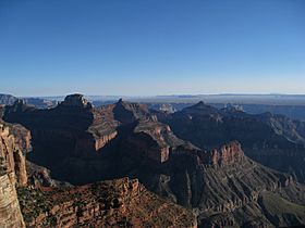
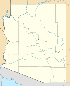
Siegfried Pyre is a mountain peak in the eastern part of the Grand Canyon in northern Arizona, United States. It stands tall at about 7,922 feet (2,415 meters) above sea level. This impressive summit is located in Coconino County.
Siegfried Pyre is found right next to the eastern edge of the Walhalla Plateau, which is part of the Grand Canyon's North Rim. It is situated southeast of a spot called Atoko Point and northeast of Naji Point. Other nearby peaks include Mount Hayden and Brady Peak.
Contents
About Siegfried Pyre
Siegfried Pyre is a notable feature within the vast and ancient Grand Canyon National Park. Its height makes it a prominent landmark in this famous natural wonder. The peak is part of the Kaibab Plateau and the larger Colorado Plateau.
Where is Siegfried Pyre?
This mountain is located in a very special place, the Grand Canyon. It's on the eastern side, near the North Rim. Imagine looking out from the Walhalla Plateau; Siegfried Pyre would be right there, standing proudly. Its location offers amazing views of the surrounding canyon landscape.
Water Flowing from the Pyre
Because Siegfried Pyre is so close to the edge of the Walhalla Plateau, it acts like a starting point for several streams that flow into the Colorado River. These streams are called "drainages." Water from the peak flows into:
- Kwagunt Creek, which goes north then east.
- Lava Creek drainage, which flows south then east.
- Chuar Creek drainage, which heads southeast then east.
This means Siegfried Pyre helps feed water into the mighty Colorado River, which carved the Grand Canyon over millions of years!
How Siegfried Pyre Was Formed
Siegfried Pyre is made up of many layers of sedimentary rock. These rocks were formed over incredibly long periods, from the Permian age all the way down to the Cambrian age. This means the rocks are hundreds of millions of years old!
Sedimentary rocks are created when layers of sand, mud, and other tiny bits of material settle and get pressed together over time. The different rock layers that make up Siegfried Pyre include:
- Toroweap Formation
- Coconino Sandstone
- Hermit Shale
- Supai Group
- Redwall Limestone
- Muav Limestone
- Bright Angel Shale
Each of these layers tells a story about what the environment was like in the Grand Canyon area millions of years ago. For example, sandstone often forms from ancient deserts, while shale might come from old mudflats.
 | Georgia Louise Harris Brown |
 | Julian Abele |
 | Norma Merrick Sklarek |
 | William Sidney Pittman |


