
Mount Hayden (Arizona) facts for kids
Quick facts for kids Mount Hayden |
|
|---|---|

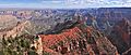
Northwest aspect seen from Point Imperial
|
|
| Highest point | |
| Elevation | 8,362 ft (2,549 m) |
| Prominence | 522 ft (159 m) |
| Isolation | 2.44 mi (3.93 km) |
| Geography | |

Mount Hayden
Location in Arizona

Mount Hayden
Location in the United States
|
|
| Location | Grand Canyon Coconino County, Arizona, US |
| Parent range | Kaibab Plateau Colorado Plateau |
| Topo map | USGS Point Imperial |
| Type of rock | Coconino Sandstone, Hermit Shale |
| Climbing | |
| First ascent | 1977 or 1978 |
| Easiest route | South Face class 5.7+ climbing |
Mount Hayden is a tall mountain in the Grand Canyon, Arizona. It stands 8,362 feet (about 2,549 meters) high. You can find it in Coconino County, in the southwestern part of the United States.
This impressive peak is about half a mile southeast of the Point Imperial viewpoint. This viewpoint is on the North Rim of the Grand Canyon. Mount Hayden rises about 5,000 feet above the bottom of Nankoweap Canyon.
Mount Hayden is also called Hayden Peak. It is named after Charles T. Hayden (1825–1900). He was an important pioneer in Arizona. People knew him as the "Father of Tempe" because he helped that city grow. He also started Arizona State University. Charles T. Hayden was the father of US Senator Carl Hayden. He also served as a judge.
The name Mount Hayden was officially accepted in 1932. This was done by the United States Board on Geographic Names. This board is in charge of naming places in the U.S.
Climbing Mount Hayden
The first time anyone reached the top of Mount Hayden was in May 1978. Joe Sharber, George Bain, and Abra Watkins made this first climb. They went up the north side of the mountain.
Another challenging climbing path is called Pegasus. This route is on the East Face. Paul Davidson and Jim Haisley were the first to climb it in 1982. The most popular way to climb Mount Hayden is the South Face route.
How Mount Hayden Formed
The very top part of Mount Hayden is made of a rock called Coconino Sandstone. This rock is cream-colored and forms steep cliffs. It is one of the younger rock layers in the Grand Canyon. This sandstone formed about 265 million years ago from ancient sand dunes.
Below the Coconino Sandstone, you'll find the reddish Hermit Formation. This layer forms slopes. Underneath the Hermit Formation is the Supai Group of rocks.
Rainwater that falls on Mount Hayden flows east. It eventually reaches the Colorado River through a stream called Nankoweap Creek. The area around Mount Hayden has a Cold semi-arid climate. This means it is generally dry and cool.
Gallery
-
-
-
-
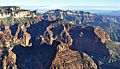
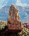
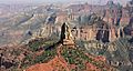
Aerial view looking northeast at Mt. Hayden
-
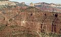
Aerial view of Mt. Hayden centered
-
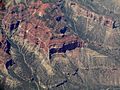
Mt. Hayden from an airplane
.jpg)
.jpg)


Images for kids
-
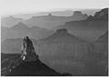
Mt. Hayden (lower left) by Ansel Adams around 1942

