Tararua Forest Park facts for kids
Quick facts for kids Tararua Forest Park |
|
|---|---|

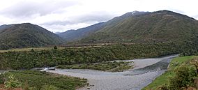
Otaki River near Otaki Forks
|
|
| Location | North Island, New Zealand |
| Nearest city | Palmerston North / Upper Hutt |
| Area | 114,993 hectares (284,150 acres) |
| Established | 1954 |
| Governing body | Department of Conservation |
The Tararua Forest Park, often called the Tararuas, is a special protected area in the Wellington area of New Zealand. It covers a huge space of about 1,150 square kilometers. The highest point in the park is a peak called Mitre, which stands tall at 1,571 meters above sea level.
This park was created in 1954. It was New Zealand's very first Forest Park. The Department of Conservation (DOC) looks after it. The park includes most of the Tararua Range mountains. Its northern edge starts near New Zealand State Highway 2.
Contents
Protecting Native Animals: Project Kaka
What is Project Kaka?
In 2010, the Department of Conservation (DOC) started a special plan called Project Kaka. The main goal of this project is to help native plants, insects, and birds grow stronger. It focuses on a large area of 22,000 hectares within the park.
Why is Project Kaka Important?
The project aims to reduce the number of harmful animals like rats, stoats, and possums. These animals are not native to New Zealand. They can harm native birds and plants. By controlling these pests, Project Kaka helps protect birds like the kaka, kakariki (a type of parrot), and kereru (New Zealand pigeon).
How Does Project Kaka Work?
Project Kaka uses different methods to control pests. One way is by dropping a special substance called 1080 from the air. This helps reduce pest numbers over large areas. They also use traps and keep a close eye on the wildlife. In 2013, DOC found that the program was working well. They heard many more native birds calling in the park. This showed that the birds were doing better. However, studies also show that rat numbers can increase again within about two and a half years after the control efforts.
Exploring the Tararua Park: Tramping Routes
The Shorman's-Kaitoke Route
One famous tramping (hiking) route in Tararua Forest Park is called Shorman's-Kaitoke. It begins in the north-east at a place called Putara. It ends in the south at Kaitoke. This classic route follows the tops of almost all the main Tararua mountains. It is about 80 kilometers long. Hikers climb and descend between 7,000 and 8,000 meters along the way.
There are almost no flat or straight parts on this track. The entire route is very open to the strong storms that often hit the Tararuas. Some experienced hikers try to finish this route in less than two days. They might carry all their own gear or have support along the way.
An Easier Valley Route
There is also another way to hike through the park. This route follows valleys along a fault line. This fault line is part of the Wellington Fault. It is to the east of the main mountain range. This route stays within the Tararua Forest Park. It involves much less climbing. It also helps hikers avoid bad weather on the mountaintops.
Weather in the Tararua Forest Park
The weather in the Tararua Forest Park can be very challenging. Winds at higher elevations can be extremely strong. They are often stronger than in many other places in New Zealand. Hikers need to be ready for this. One way to deal with very strong winds is to walk bent over with your hands close to the ground. This helps you stay balanced.
 | Anna J. Cooper |
 | Mary McLeod Bethune |
 | Lillie Mae Bradford |


