Tawatahi River facts for kids
Quick facts for kids Tawatahi River |
|
|---|---|

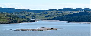
Tawatahi River and Te Teko Island
|
|
| Country | New Zealand |
| Physical characteristics | |
| Main source | 176 m (577 ft) |
| River mouth | Raglan Harbour 0 m (0 ft) |
| Length | 2 km (1.2 mi) |
The Tawatahi River is a short river in the Waikato Region of New Zealand. It is located on the North Island. The river flows into the northern part of Raglan Harbour.
The River's Rocks
The area where the Tawatahi River begins is very special. It has a place called "New Katuku Trig / Pukewharangi Hill". This spot is important because it has very old fossils. These fossils are from the Oligocene period. That was about 41 million years ago!
Most of the rocks in the river valley are called Kotuku siltstone. This rock is usually light blue-grey. It feels a bit like mud that has turned hard. It also has calcium carbonate in it. This means it is a bit chalky.
Higher up the hills, you will find other rocks. These are mainly Mangiti Sandstone and Patikirau Siltstone. They are also chalky rocks. All these rocks formed a long, long time ago. They were laid down on the bottom of a deep ocean.
Other Names for the River
The Tawatahi River has been known by a few other names. One of these names was Burgess's Creek. This name came from a farmer named James Burgess. He owned land near the river. His farm was on Burgess Point, which is to the west of the river.
James Burgess was a shepherd in the late 1800s. He used to work at Te Akau Station. This large farm used to include the area around the Tawatahi River. Mr. Burgess cleared the flax plants from the peninsula. Then he planted grass for his sheep to eat.
River Wildlife
In 2012, scientists studied the area where the river meets the sea. This area is called an estuary. They found many different plants and animals living there.
The estuary had a wide area of rushes. These are tall, grass-like plants. Beyond the rushes, there was a native forest. Many interesting creatures live in the mud. These include mud crabs and titiko. Titiko are a type of snail.
The plants found there include the coastal daisy. There is also makaka and oioi. Other plants are fescue grass and marsh clubrush. You can also find remuremu and sea primrose. Small yellow flowers like sand buttercup grow there too.
The forest has many native trees. These include the bright yellow kowhai tree. There are also kanuka trees. Other trees are miro and tanekaha. You might also see hangehange plants.
 | Aurelia Browder |
 | Nannie Helen Burroughs |
 | Michelle Alexander |

