Nojpetén facts for kids
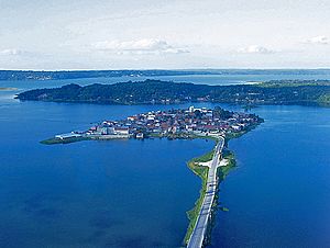
Nojpetén was the capital city of the Itza Maya kingdom of Petén Itzá. It was located on an island in Lake Petén Itzá in northern Guatemala. Today, the modern town of Flores stands on this same island. People have lived on this island without stopping since ancient times. Nojpetén had strong defensive walls around the lower parts of the island. The Itza people might have built these quickly when they felt threatened by the Spanish or other Maya groups.
Contents
Understanding the Names of Nojpetén
The city of Nojpetén was known by a few names. Years after his journey, a Spanish explorer named Bernal Díaz del Castillo called the city Tayasal. This name likely came from the Itza language, meaning "at the place of the Itza."
The Itza king, Kan Ek', called the city Nojpetén when he spoke to the Spanish in 1698. In the Itza language, Nojpetén means "great island."
How Nojpetén Was Founded
Archaeologists have found the oldest signs of people on the island from about 900 to 600 BC. The city grew a lot between 250 and 400 AD.
Historical records say that the Itza people founded Nojpetén in the mid-1400s AD. They moved south around 1441–1446. This happened after another Maya group, the Xiu Maya, took over their old city of Mayapan. When the Itza settled on the island, they divided their new capital into four sections. Each section was based on different family groups.
Life and Buildings in Nojpetén

Nojpetén was a very crowded city. It had many buildings, including temples, palaces, and houses with thatched roofs. Experts believe about 2,000 people lived in the city, in around 200 houses. The way the streets are laid out in modern Flores might be similar to how Nojpetén was planned. It had main streets running north-south and east-west, meeting at the highest point. This spot is now the main town square and the Catholic church.
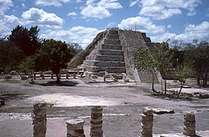
In 1698, Spanish visitors described the city as having twenty-one temples. The largest temple was called a castillo by the Spanish. It had a square base, measuring about 16.5 meters (54 feet) on each side. This temple had nine stepped levels and faced north. Its design was very similar to the main pyramids found at Chichen Itza and Mayapan in Yucatán.
When a Spanish missionary named Andrés de Avendaño y Loyola visited in early 1696, nine of the temples had recently been burned. This happened during an attack by the Kowoj Maya. The temples were rebuilt after the attack. Many houses were also destroyed at that time. The Spanish later destroyed many of the Itza's religious statues, which they called idols, after they conquered the city.
The Spanish Conquest of Nojpetén
Nojpetén was the last major Maya kingdom to be conquered by the Spanish. This happened in 1697. Martín de Ursúa y Arismendi arrived at Lake Petén Itzá in February 1697. He had 235 Spanish soldiers and 120 native workers with him.
Ursúa launched a full attack on March 10, 1697. He used a large boat powered by oars. The Spanish fired cannons at the island, causing many Itza defenders to die. The Itza people were forced to leave their city.
The Spanish then renamed Nojpetén. They called it Nuestra Señora de los Remedios y San Pablo, Laguna del Itza. This long name was often shortened to Remedios in old documents. Sometimes it was just called Petén or El Presidio (meaning "the garrison"). In 1831, the government renamed it Flores. This new name honored the Guatemalan leader, Cirilo Flores Estrada.
Archaeological Discoveries at Nojpetén
From 2003 to 2004, archaeologists did important digs on the island. This happened during a big project to improve the island's water and sewage systems. The large amount of digging allowed them to explore almost every street and alleyway in the city.
The archaeological studies showed that the island was very densely populated for a long time. The earliest signs of people were found on the highest part of the island. This area is now in front of the departmental governor's offices. These findings date back to about 900–600 BC.
Archaeologists also found a chultun (a Maya storage pit) in the middle of the island. It contained pottery from about 600 BC to 250 AD. While older remains were not very common, the site grew a lot between 250 and 400 AD.
...Tayasal is on a small island surrounded by water, and unless [the natives] go by canoe, they cannot enter by land; and they whitewash the houses and temples so they may be seen from more than two leagues distant...
See also
 In Spanish: Tayasal para niños
 | Bayard Rustin |
 | Jeannette Carter |
 | Jeremiah A. Brown |


