Taylor, Alabama facts for kids
Quick facts for kids
Taylor, Alabama
|
|||
|---|---|---|---|
|
|||

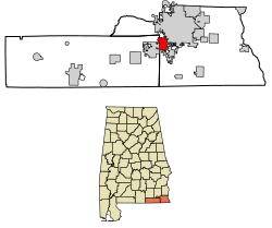
Location of Taylor in Geneva County and Houston County, Alabama.
|
|||
| Country | United States | ||
| State | Alabama | ||
| Counties | Houston, Geneva | ||
| Area | |||
| • Total | 7.31 sq mi (18.94 km2) | ||
| • Land | 7.23 sq mi (18.73 km2) | ||
| • Water | 0.08 sq mi (0.21 km2) | ||
| Elevation | 331 ft (101 m) | ||
| Population
(2020)
|
|||
| • Total | 2,262 | ||
| • Density | 312.78/sq mi (120.76/km2) | ||
| Time zone | UTC-6 (Central (CST)) | ||
| • Summer (DST) | UTC-5 (CDT) | ||
| ZIP codes |
36301, 36305
|
||
| Area code(s) | 334 | ||
| FIPS code | 01-75096 | ||
| GNIS feature ID | 0127718 | ||
Taylor is a small town located in the state of Alabama, in the United States. It is found in both Geneva and Houston counties. The town was first settled in the 1870s. It was named after an early family who helped set up the first post office there.
Taylor officially became an incorporated town in June 1967. This means it gained its own local government. It is also part of the larger Dothan Metropolitan Area. According to the 2020 census, about 2,262 people live in Taylor.
Contents
Where is Taylor Located?
Taylor is in the western part of Houston County, Alabama. A small part of the town also stretches into Geneva County. It is near other towns like Dothan to the northeast and Rehobeth to the southeast. Malvern is to the southwest.
Alabama State Route 52 (also known as Hartford Highway) runs through the northern part of Taylor. This road can take you about 6 miles (9.7 km) northeast to the center of Dothan. It also goes about 9 miles (14.5 km) southwest to Slocomb.
How Big is Taylor?
The U.S. Census Bureau states that Taylor covers a total area of about 7.3 square miles (18.9 km²). Most of this area, about 7.2 square miles (18.7 km²), is land. A small part, about 0.08 square miles (0.2 km²), is water.
Who Lives in Taylor?
The population of Taylor has changed over the years. Here's a quick look at how many people have lived there during different census years:
| Historical population | |||
|---|---|---|---|
| Census | Pop. | %± | |
| 1970 | 174 | — | |
| 1980 | 1,003 | 476.4% | |
| 1990 | 1,352 | 34.8% | |
| 2000 | 1,898 | 40.4% | |
| 2010 | 2,375 | 25.1% | |
| 2020 | 2,262 | −4.8% | |
| U.S. Decennial Census 2013 Estimate |
|||
Taylor's Population in 2010
In 2010, there were 2,375 people living in Taylor. These people lived in 835 households, and 639 of those were families. The town had about 330 people per square mile (127 per km²). There were 966 housing units, which are places where people live, like houses or apartments.
Most people in Taylor were White (87.5%). About 7.2% were Black or African American. Other groups included Native American (0.8%), Asian (0.1%), and people from other races (2.4%). About 2.1% of people identified with two or more races. Around 5.2% of the population was Hispanic or Latino.
Many households (43%) had children under 18 living with them. About 53.8% were married couples. Some households (18.2%) were led by a female without a husband present. About 19.3% of households had just one person living there.
The average age of people in Taylor was 31.5 years old. About 31.6% of the population was under 18. About 7.8% were 65 or older.
Taylor's Population in 2020
As of the 2020 United States census, Taylor had 2,262 residents. There were 752 households and 534 families living in the town.
The racial makeup of Taylor in 2020 was:
| Race | Number of People | Percentage |
|---|---|---|
| White (not Hispanic or Latino) | 1,843 | 81.48% |
| Black or African American (not Hispanic or Latino) | 204 | 9.02% |
| Native American | 9 | 0.4% |
| Asian | 7 | 0.31% |
| Pacific Islander | 2 | 0.09% |
| Other/Mixed | 94 | 4.16% |
| Hispanic or Latino | 103 | 4.55% |
See also
 In Spanish: Taylor (Alabama) para niños


