
Tekantó Municipality facts for kids
Quick facts for kids
Tekantó
|
||
|---|---|---|

Municipal Building of Tekantó
|
||
|
||
| Motto(s):
Siyan Kán Tekantó (Illustrious Tekantó)
|
||

Location of the Tekantó Municipality in Yucatán
|
||

Tekantó Municipality
Location in Mexico
|
||
| Country | ||
| State | ||
| Mexico Ind. | 1821 | |
| Yucatan Est. | 1824 | |
| Municipality Est. | 1900 | |
| Named for | Place of the yellow flint | |
| Government | ||
| • Type | ||
| Area | ||
| • Total | 47.25 km2 (18.24 sq mi) | |
| Elevation | 10 m (30 ft) | |
| Population
(2009)
|
||
| • Total | 4,079 | |
| • Density | 86.328/km2 (223.59/sq mi) | |
| • Demonym | Tekantence | |
| Time zone | UTC-6 (Central Standard Time) | |
| • Summer (DST) | UTC-5 (Central Daylight Time) | |
| Postal Codes |
Tekanto 97520, Tixkochoh 97522
|
|
| Area code(s) | 991 | |
| Population History |
by Year
|
|
| INEGI Code | 078 | |
| Major Airport | Merida (Manuel Crescencio Rejón) International Airport | |
| IATA Code | MID | |
| ICAO Code | MMMD | |
| Municipalities of Yucatán | ||

Tekantó Municipality is a small area in the Mexican state of Yucatán. Its name comes from the Yucatec Maya language and means "Place where there is yellow flint." The municipality was created in 1900. Its main town, also called Tekantó, is located about 54 kilometers (33 miles) east of Merida.

Contents
Exploring Tekantó's Past
Tekantó has a long and interesting history. Before the Spanish arrived, this area was part of a powerful Mayan region called Ah Kin Chel.
Key Dates in Tekantó's History
- Before 1546: The region was part of the Mayan chieftainship of Ah Kin Chel.
- 1546: The Spanish completed their conquest of Yucatán.
- 1567: A Franciscan Mission was started in Tekantó.
- 1581: Cristobal Sanchez took over Tekantó and Tepakan under the encomienda system. This system allowed Spanish settlers to control land and the people living on it.
- 1688: The San Augustin Tekantó convent and mission were finished.
- 1700: Antonia Pacheco and Juan N. Calderón were in charge of Tekantó under the encomienda system.
- 1720: The encomienda system ended. It was replaced by the Hacienda system, where workers were directly employed by hacienda owners. Sanlatah is an example of a hacienda in Tekantó.
- 1821: Yucatán declared its independence from Spain.
- 1825: Tekantó was part of the La Costa region, with Izamal as its capital. At this time, Yucatán was much larger than it is today.
- 1848: During the Caste War of Yucatán, Colonel Bello and his 1,000 men marched through Tekantó after a siege in Izamal.
- 1900: Tekantó Municipality was officially created, and Tekantó became its main town.
Understanding Tekantó's Shield
In 1990, the Mexican government asked all municipalities to create their own shield or coat of arms. Tekantó's city council held a contest to design theirs. The final design combines ideas from several people.
What the Shield Represents
- A sun with 13 rays shows the Mayan "supraworld" (the world above).
- An image of the Mayan chief Ah Kin Chel is on a green background.
- A gold background with 9 blades of henequen represents the Mayan "infraworld" (the world below). The gold color also shows the area's economic importance.
- Two branches of a plant called Kantó are on the sides. Some say this plant gave the town its name.
- At the bottom, a silver ribbon has the words "Siyan Kán Tekantó," which means "illustrious" or "famous Tekantó."
Who Lives in Tekantó?
The population of Tekantó is about 4,000 people. In 2000, a census showed that 1,655 people spoke the local language, Yucatec Maya. This is similar to the average for the whole state of Yucatán.
Communities of Tekantó
The municipality has four main communities. The largest is the town of Tekantó itself. The other communities are Tixkochoh, San Francisco Dzon, and Sanlatah.
- Tekantó: 3,224 people
- Tixkochoh: 455 people 21°00′50″N 89°04′50″W / 21.0138°N 89.0806°W
- San Francisco Dzon: 127 people 20°59′01″N 89°08′36″W / 20.9835°N 89.1433°W
- Sanlatah: 83 people 21°02′33″N 89°08′48″W / 21.0426°N 89.1466°W
There are also about 53 people living in smaller, isolated homes or tiny communities like San Diego Rodriguez 20°59′32″N 89°06′51″W / 20.9923°N 89.1143°W. In 2005, there were 942 houses in the municipality.
Tekantó's Geography

Neighboring Areas
Tekantó Municipality is surrounded by other municipalities:
- To the north: Suma and Teya
- To the south: Izamal
- To the east: Tepakán
- To the west: Bokobá
Distances to Nearby Cities
Here are the distances from the main town of Tekantó to other important cities:
- Izamal, Yucatán: 13 kilometers (8 miles) southeast, with about 14,954 people.
- Motul, Yucatán: 21 kilometers (13 miles) west-northwest, with about 21,109 people.
- Merida, Yucatán: 54 kilometers (33 miles) west, with about 717,175 people.
Tekantó also has a train station on an old railway line that used to connect Mérida and Valladolid through Izamal.
Climate and Weather
Tekantó has a warm climate. It usually rains in the early summer, followed by dry periods in late summer. The average temperature each year is 26.5 °C (79.7 °F). The average rainfall is 50 millimeters (2 inches). Winds mostly come from the northeast. The air is most humid in December (89%) and least humid in March (66%). The rainy season is from May to July.
Plants and Animals
Tekantó has small areas of low forest that lose their leaves in certain seasons. You can find plants like poppy, ceiba, and flamboyán.
Common animals in the area include:
- Mammals: Rabbits, raccoons, deer, and armadillos.
- Reptiles: Various snakes, iguanas, and turtles.
- Birds: Doves, tzutzuy, quail, and tórtola.
Places to Visit and Fun Activities
Amazing Buildings
San Augustin Tekantó is a very impressive building. It's one of the biggest churches in Yucatán outside of Merida. It was an important early Franciscan Convent in the region.


The original mission started in 1567. An inscription on the church shows it was finished in 1688, more than a hundred years after the mission began. Nearby, you can also find the old haciendas of Sanlatah and San Francisco Dzon.
Popular Celebrations
- San Augustin Fiesta: Every year from August 26 to 28, there's a big party to honor San Augustin, the patron saint of Tekantó.
- Santo Christo de Citilcún Fair: From November 15 to 26, an annual fair celebrates Santo Christo de Citilcún. On November 15, a procession brings Santo Christo de Citilcún to Tekantó. After the procession, there are fireworks and food in the town square. Later in the month, there are many fun events, including folk dancing at the town hall. Sometimes, a temporary bullfighting ring is set up for bullfights and other shows.
Exploring the Area Around Tekantó
- The ancient ruins of Ake are about 20 kilometers (12 miles) southwest of Tekantó.
- Izamal, famous for its monastery, old carriages, and Mayan pyramids, is only 13 kilometers (8 miles) southeast.
Tekantó's Economy


Tekantó is in the north-central part of Yucatán, an area known for growing henequen. For many years, until the late 1900s, the main economic activity was the henequen industry, which used the agave plant.
When the henequen industry declined, Tekantó's economy changed. Today, the main crop is maize (corn). Farmers also grow kidney beans, various vegetables, watermelon, and some types of chili peppers. Raising pigs and poultry (chickens) is also common. Beekeeping, which is raising bees for honey, is another important activity in the area.
Education in Tekantó

Here's a look at the schools in Tekantó and its communities as of the year 2000:
| Name of School | Locality | Level | Student population |
|---|---|---|---|
| FRANCISCO I. MADERO | Tekantó | Pre-school | 89 |
| PREESCOLAR COMUNITARIO | San Francisco Dzon | Pre-school | 6 |
| SAYABI HA | Tixkochoh | Pre-school | 21 |
| ANDRES QUINTANA ROO | Tekantó | Primary | 164 |
| GUILLERMO PRIETO | Tekantó | Primary | 247 |
| PRIMARIA COMUNITARIA | San Francisco Dzon | Primary | 27 |
| PIPILA | Tixkochoh | Primary | 47 |
| GUILLERMO PRIETO | Tekantó | Secondary | 223 |
Famous People from Tekantó
One notable person from Tekantó was Marrufo Cetina, Carlos Anastasio. He was a mandolin player and a musical composer who lived from 1875 to 1932.
Images for kids
-
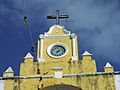
The clock over San Augustin Tekantó.
-
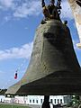
San Augustin Tekantó's Franciscan Bell.
-
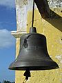
San Augustin Tekantó's American Bell.
-
Local people in traditional dress.
-
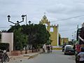
Downtown Tekantó.
-
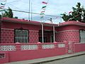
A nicer home in Tekantó.
-
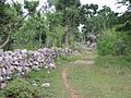
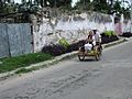
A typical rural street.
-
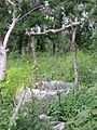
A Well at the edge of town.
-
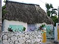
A traditional Cottage.
-
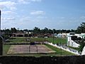
The Zócalo (Main Plaza).


See also
 In Spanish: Tekantó (municipio) para niños
