
Izamal facts for kids
Quick facts for kids
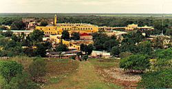
Izamal
|
|
|---|---|
 |
|
| Nickname(s):
The Yellow City, The City of Three Cultures
|
|

Location of Izamal, Yucatan
|
|
| Country | Mexico |
| State | Yucatan |
| Municipality | Izamal |
| City Founded | December 4, 1841 |
| Elevation | 13 m (43 ft) |
| Population
(INEGI, 2005)
|
|
| • Total | 15,101 |
| Time zone | UTC-6 (Central Standard Time) |
| • Summer (DST) | UTC-5 (Central Daylight Time) |
| ZIP code |
97540
|
| Area code(s) | 988 |
| INEGI Code | 310400001 |
Izamal (Spanish: [isaˈmal]) is a small, colorful city in Mexico. It is located in the state of Yucatán, about 72 kilometers (45 miles) east of the capital city, Mérida.
People have lived in Izamal for a very long time, since ancient times. In 2000, about 15,000 people lived there. Izamal is famous for two nicknames: the Yellow City because most of its buildings are painted bright yellow, and the City of Hills because it has many ancient temple pyramids that look like hills.
Contents
Ancient Izamal: A Maya City
Izamal is a very important archaeological site from the Pre-Columbian Maya civilization. It was likely the largest city in the northern Yucatán Plains, covering at least 53 square kilometers (20 square miles). Its huge buildings contain over 1,000,000 cubic meters of stone.
Connecting Ancient Cities
Two ancient roads, called sacbeob (pronounced sah-KAY-ob) in Maya, connected Izamal to other important centers. One road stretched 29 kilometers (18 miles) west to the Ruins of Ake. Another went 18 kilometers (11 miles) south to Kantunil. These roads show how powerful Izamal was in religion, politics, and trade over a large area.
Building Techniques of Izamal
The people of Izamal used a special way of building. They used huge carved stone blocks. Their buildings had unique features like rounded corners and special roof designs. These building styles can also be seen in other nearby ancient cities like Ake.
History of the City
Izamal was founded a very long time ago, between 750 and 200 BC. People lived there continuously until the Spanish arrived. The most active building period was from 200 BC to 800 AD. The city was partly left empty when Chichen Itza became powerful. However, by the end of the Pre-Columbian era, Izamal was a major place for pilgrimages, almost as important as Chichen Itza. Its main temples were dedicated to the creator god Itzamna and the Sun god Kinich Ahau.
Exploring the Great Structures
Five massive ancient structures are still easy to see in Izamal today.
- Kinich Kak Moo is a huge pyramid dedicated to the Maya Sun god. Its base covers over 8,000 square meters (2 acres), and the pyramid itself has ten levels.
- To the southeast is another large temple called Itzamatul.
- South of what was once the main plaza, stood a huge building called Ppap Hol Chak. Part of it was destroyed when a Spanish church was built in the 1500s.
- The southwest side of the plaza has another pyramid, the Hun Pik Tok.
- To the west are the remains of the temple known as Kabul. In the 1840s, a large stucco mask was still visible on one side, as shown in a drawing by Frederick Catherwood.

These large man-made mounds were likely built over many centuries. They originally supported grand palaces and temples. Other important buildings that have been restored and can be visited include Xtul (The Rabbit), Habuc, and Chaltun Ha.
Archaeologists have found over 163 important structures in Izamal. They have also located thousands of ancient homes in the surrounding areas.
Spanish Colonial Era: New Buildings, Old Stones
After the Spanish conquest of Yucatán in the 1500s, a Spanish colonial city was built on top of the existing Maya city. It was too much work to completely level the huge Maya structures. So, the Spanish built a small Christian church on top of the great pyramid. They also built a large Franciscan Monastery on top of the acropolis (a high part of the city). This monastery was named after San Antonio de Padua.
The monastery was finished in 1561. Its open courtyard is still the second largest in the world, after the one at the Vatican. Most of the cut stones from the ancient Maya city were reused to build the Spanish churches, the monastery, and other buildings.
Izamal was once the first home for the Bishops of Yucatán before they moved to Mérida. Diego de Landa, an important bishop, lived here.
Modern Izamal: Changes and Tourism
Izamal was first made a city on December 4, 1841. It lost its city status in 1923 but became a city again on December 1, 1981.
For many years, the production of henequen (a plant fiber) was important to Izamal's economy. When this industry declined in the 1960s, the government started working to make Izamal a tourist spot. This led to big changes in the city's look.
The Yellow City's Transformation
Izamal's famous yellow and white buildings are thanks to Jorge Carlos González Rodríguez, who was mayor from 1959 to 1961. He ordered that all commercial signs be removed and buildings painted yellow and white. In 1965, Governor Luis Torres Mesías ordered some buildings around the San Antonio de Padua convent to be taken down. He and the next governor also changed Plaza Zamná from a public market into a park.
A Papal Visit
Pope John Paul II visited Izamal in August 1993. He held a mass there and gave a silver crown to the statue of the Virgin Mary.
Izamal Today: A Place of Faith and Culture
Today, Izamal is still a place where people go on pilgrimages in the Yucatán state. They come to honor Roman Catholic saints. Many people believe that several saint statues in Izamal can perform miracles. A very old statue from the colonial era, "Our Lady of Izamal," is especially honored. She is the patron saint of the Yucatán state.
The Yucatec Maya language is still widely spoken in Izamal, often as much as Spanish. It is the main language in most homes. Many signs in the city are written in both languages.
Major festivals are held in Izamal on April 3, May 3, August 15, and December 8.
Izamal is also home to a distillery that makes a type of mezcal (an alcoholic drink) from local agave plants.
In 2002, Izamal was named a "Pueblo Mágico" (Magical Town), a special title given to towns in Mexico that offer a unique cultural experience.
Climate
| Climate data for Izamal | |||||||||||||
|---|---|---|---|---|---|---|---|---|---|---|---|---|---|
| Month | Jan | Feb | Mar | Apr | May | Jun | Jul | Aug | Sep | Oct | Nov | Dec | Year |
| Mean daily maximum °C (°F) | 30.1 (86.2) |
31.3 (88.3) |
33.2 (91.8) |
35.2 (95.4) |
35.7 (96.3) |
34.7 (94.5) |
33.8 (92.8) |
33.7 (92.7) |
33.7 (92.7) |
32.3 (90.1) |
31 (88) |
30.4 (86.7) |
32.9 (91.2) |
| Mean daily minimum °C (°F) | 17.0 (62.6) |
17 (63) |
18.5 (65.3) |
20.2 (68.4) |
21.5 (70.7) |
22.1 (71.8) |
21.7 (71.1) |
21.9 (71.4) |
21.8 (71.2) |
20.6 (69.1) |
19.3 (66.7) |
18 (64) |
20 (68) |
| Average precipitation mm (inches) | 38 (1.5) |
30 (1.2) |
20 (0.8) |
23 (0.9) |
81 (3.2) |
140 (5.6) |
130 (5.2) |
160 (6.4) |
190 (7.4) |
97 (3.8) |
33 (1.3) |
30 (1.2) |
980 (38.5) |
| Source: Weatherbase | |||||||||||||
Gallery
-
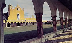
Main arcade of convent and church entrance
-
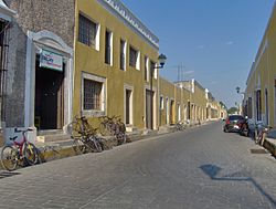
The placid streets of Izamal
-
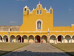
Monastery facade
-
Arcade with pyramid in background
-
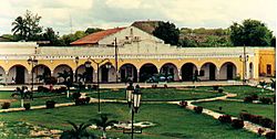
Convent as viewed from atop Kinich Kak Mo pyramid


See also
 In Spanish: Izamal para niños
