
Tell Arpachiyah facts for kids
| [[File::None at this time|frameless]] | |

Location in Iraq
|
|
| Alternative name | Tepe Reshwa |
|---|---|
| Location | Nineveh Province, Iraq |
| Region | Northern Mesopotamia |
| Coordinates | 36°22′17″N 43°11′52″E / 36.37139°N 43.19778°E |
| Type | tell |
| Site notes | |
| Excavation dates | 1933, 1976 |
| Archaeologists | M. Mallowan, J. Cruikshank Rose, I. Hijara |
Tell Arpachiyah is a very old archaeological site in Nineveh Province, Iraq. It is located near the modern city of Mosul. The name "Tell Arpachiyah" comes from a nearby village. The mound where the site is found is also known as Tepe Reshwa.
Another ancient site from the Neolithic period, called Tepe Gawra, is also in the Mosul area.
Discovering Tell Arpachiyah
Tell Arpachiyah is a small tell, which is a mound made up of layers of old settlements. It's like a big hill formed over thousands of years as people built new homes on top of old ones. This mound is about 67 meters wide and 5.5 meters tall. The whole site covers an area about 125 meters across.
Archaeologists first explored the site in 1928. Then, in 1933, a team from the British School of Archaeology in Iraq started digging there. This team included Max Mallowan, John Cruikshank Rose, and even the famous mystery writer Agatha Christie! More digging was done in 1976 by a team led by Ismail Hijara.
During these digs, they found several buildings from the ancient Halaf culture. These included round buildings called tholoi and a special building known as the "Burnt House." They also found many pieces of Halaf pottery and clay seals. In addition, they discovered an Ubaid period cemetery with 50 graves.

Life in Ancient Tell Arpachiyah
People lived at Tell Arpachiyah during two important ancient periods: the Halaf period and the Ubaid period. These periods were thousands of years ago, before writing was invented.
It seems that the people of Tell Arpachiyah were very good at making pottery. Many pieces of pottery found here have helped experts understand the timeline of the Halaf period. The different styles and designs of the pottery show how the culture changed over time.
Gallery
-
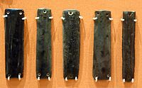
Obsidian jewelry. It is unknown whether they were sewn to clothing or they were joined together to make a necklace, bangle, or belt. 6000-5000 BC
-
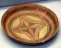
Jar. The surface is painted with lustrous black paint on a salmon-pink slip. Halaf period, 6000-5000 BC
-
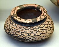
Bowl. The bowl was found fragmented and the pieces were scattered over the floor. 6000-5000 BC
-
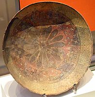
Shallow plate. The interior is decorated with a floral design in the center, with polychrome in black and red on the buff surfaces. 6000-5000 BC
-
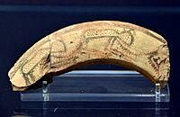
Sherd. The exterior is painted with a design; lustrous black paint on apricot-coloured clay with a burnished surface. The design of spotted animals possibly represents leopards


._The_exterior_is_painted_with_a_design;_lustrous_black_paint_on_apricot-colored_clay_with_a_burnished_surface._The_design_of_spotted_animals_possibly_represents_leopards._From_Tell_Arpachiyah.jpg)
See also
- Cities of the ancient Near East
- Come, Tell Me How You Live
