
Tepe Gawra facts for kids
| [[File::None at this time|frameless]] | |

Location in Iraq
|
|
| Location | Nineveh Province, Iraq |
|---|---|
| Region | Northern Mesopotamia |
| Coordinates | 36°29′44″N 43°15′37″E / 36.49556°N 43.26028°E |
| Type | tell |
| Site notes | |
| Excavation dates | 1849, 1927, 1932-1938 |
| Archaeologists | Austen Layard, E.A. Speiser, Charles Bache |
Tepe Gawra is an ancient settlement in Mesopotamia, located about 15 miles northeast of Mosul in northwest Iraq. This site was home to people for a very long time, from around 5000 BC to 1500 BC.
It's quite close to other famous ancient cities like Nineveh and Khorsabad. At Tepe Gawra, archaeologists have found remains from different important periods. These include the Halaf period, the Ubaid period, and the Uruk period (from 4000 to 3100 BC). It also shows signs of a time when the Halaf and Ubaid cultures were changing, around 5500 to 5000 BC.
Another ancient village called Tell Arpachiyah was active at the same time and is located nearby.
Contents
Exploring Ancient Tepe Gawra
_4000_BCE.jpg)
The site of Tepe Gawra is a large mound, known as a tell. It is about 120 meters wide and 22 meters tall. This mound was formed over thousands of years as people built new homes and buildings on top of older ones.
The first quick look at the site was done by Austen Layard in 1849. He dug some trenches but only found pieces of pottery. Later, between 1927 and 1938, a team of archaeologists from the University of Pennsylvania and the American Schools of Oriental Research did a much bigger excavation.

These archaeologists found many interesting things. They discovered different ways people were buried, including in graves and tombs. Some tombs were made of mudbrick, while others used stone. Inside, they found valuable items like ivory combs and gold decorations.
They also found about 700 ancient "seals." These were like early stamps used to mark ownership or sign documents. Some were stamp seals with geometric or animal designs. Later, they found cylinder seals, which were small cylinders rolled over clay to leave an impression.

The archaeologists divided the site into different layers, called "levels." Each level represents a different time period:
- Levels XX: This is the oldest layer, from the Halaf culture (around 5500-4900 BC).
- Levels XIX-XII: These layers belong to the Ubaid period (around 4900-4000 BC).
- In Level XIII, three large temples were built.
- Level XII shows signs that the site was violently destroyed.
- Levels XIIa-VIII: This is called the Gawra Period (around 4000-2900 BC). It happened at the same time as the Uruk period.
- In Level XIa, a large round fortress was built.
- In Level VIIIc, four big buildings were found. Experts first thought they were temples, but later realized some were used for managing the community.
- Levels VII-IV: These are later periods, including the Early Dynastic and Akkadian times (around 2900-1800 BC).
More recently, in 2001, an expert named Mitchell Rothman looked at all the old data again. He helped to make the timeline of the site even clearer.
Discovering a Larger Ancient City
In 2021, a team from the University of Toronto started looking for a "Lower Town" at Tepe Gawra. A Lower Town would be a larger settlement area around the main mound. They found many pottery pieces scattered on the ground around the mound.
Using satellite images and drones, they found two smaller mounds nearby. In 2022, they walked over the area, collecting pottery and stone tools. Their studies showed that a large Lower Town, about 24 hectares in size, existed at Tepe Gawra around 2000 BC.
Sadly, some parts of the site have been damaged over time. Modern olive groves have caused harm, and in recent years, a terrorist group dug many tunnels in the main mound, which is a big concern for the site's safety.
Life at Tepe Gawra

The excavations show that Tepe Gawra was almost continuously lived in for about 3,500 years. During ancient times, several streams fed by springs flowed through or near the site. Today, these streams are dry because of modern water pumping for olive farms.
Tepe Gawra is famous for having some of the earliest known temples. One temple, from around 4200 BC, was decorated with pilasters (flat, decorative columns) and recesses (indented parts of a wall).
The time period from 3500 to 2900 BC is even named the "Gawra Period" because of the important discoveries made here. Tepe Gawra was also part of the "Uruk Expansion." This is when the ancient city of Uruk spread its trade and influence across a wide area, including northern Mesopotamia.
Early Use of Metals

Tepe Gawra is one of the earliest places in the Near East where people used gold or electrum (a natural mix of gold and silver). Small items like wire and beads made of these precious metals have been found here. The use of gold continued at Tepe Gawra into later periods, starting around 2900 BC.
Archaeologists also found objects made of arsenical copper at Tepe Gawra. This was an early type of metal used before people learned to make bronze. A single pin made of tin-bronze was also found, showing how metalworking developed over time.
See also
Images for kids
-
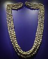
A necklace made from snail shells found at Tepe Gawra, dating back to 4000 BC.
-
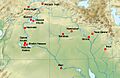
Tepe Gawra on a map of Uruk period sites in Upper Mesopotamia.
-
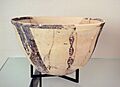
Pottery from the early Ubaid period (5100-4500 BC) found at Tepe Gawra.
-

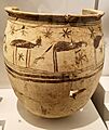
Pottery from the Northern Ubaid period, found at Tepe Gawra and other sites.
-
A storage jar found at Tepe Gawra.
