Telopea, New South Wales facts for kids
Quick facts for kids TelopeaSydney, New South Wales |
|||||||||||||||
|---|---|---|---|---|---|---|---|---|---|---|---|---|---|---|---|

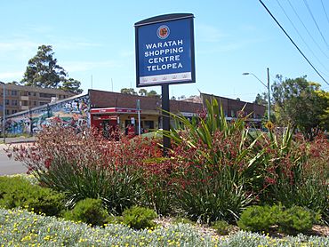
Waratah Shopping Centre c. 2007
|
|||||||||||||||
| Population | 5,426 (2016 census) | ||||||||||||||
| • Density | 3,620/km2 (9,400/sq mi) | ||||||||||||||
| Postcode(s) | 2117 | ||||||||||||||
| Elevation | 40 m (131 ft) | ||||||||||||||
| Area | 1.5 km2 (0.6 sq mi) | ||||||||||||||
| Location | 23 km (14 mi) north-west of Sydney CBD | ||||||||||||||
| LGA(s) | City of Parramatta | ||||||||||||||
| State electorate(s) | Epping | ||||||||||||||
| Federal Division(s) | Parramatta | ||||||||||||||
|
|||||||||||||||
Telopea is a suburb located in Greater Western Sydney, New South Wales, Australia. It is about 23 kilometres north-west of the main city area of Sydney. Telopea is part of the City of Parramatta local government area. The suburb is surrounded by Kissing Point Road to the south and Pennant Hills Road to the north.
Contents
What's in a Name?
Telopea gets its name from a beautiful flower called Telopea speciosissima. This flower is also known as the New South Wales waratah. It used to grow a lot in this area before people settled here. The waratah is now the official flower symbol of New South Wales.
Getting Around Telopea
You can get around Telopea using Busways bus route 545.
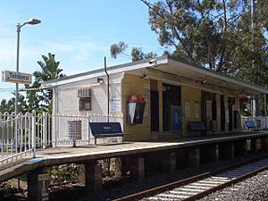
Telopea used to have its own train station, Telopea railway station. It was on the Carlingford railway line. However, in 2015, plans were made to change part of this train line into a light rail system. This project is called the Parramatta Light Rail. Because of this, Telopea train station closed on January 5, 2020. Now, a temporary bus route (535) helps people travel between Carlingford and Parramatta.
Shopping and Local Businesses
The main shopping area in Telopea is the Waratah Shopping Centre. It's located on Benaud Place. Here, you can find different shops like a newsagent, a chemist, a bakery, and a hair salon. There's also a post office and a kebab shop. You can find a few more small shops across from where the railway station used to be, on Adderton Road.
Homes in Telopea
Most of the homes in Telopea are single houses or smaller apartment buildings. Many of these houses were built after World War II. The old train line goes right through the middle of the suburb. You'll find more medium-sized apartment buildings close to where the train line used to be.
Parks and Nature
Telopea has a large area of natural bushland on its western side. This bushland is next to the Oatlands golf course. It's called the Vineyard Creek Reserve. Inside the reserve, there's a creek that gets its water from a natural spring. The creek has several small waterfalls. It then goes underground before reaching Kissing Point Road. This creek and the bushland are protected because they are important natural areas.
Places to Worship
- A local Anglican Church holds services in Telopea on Saturday evenings. They also meet in Dundas on Sundays.
- The Telopea Christian Centre is another church in the area.
Community Spots
Telopea has several useful places for the community. These include a primary school, a special educational facility, a library, and a community hall. There's also a community garden where people can grow plants together.
Historic Places
Telopea has a few sites that are important for their history. These are called heritage-listed sites. One example is a place called Redstone, located at 34 Adderton Road.
Who Lives Here?
In 2016, about 5,426 people lived in Telopea.
- The ages of people in Telopea are quite similar to the rest of Australia.
- Many people living in Telopea were born in Australia. Other common countries of birth include China, South Korea, and Hong Kong.
- While many people speak English at home, other languages like Mandarin, Korean, Cantonese, Arabic, and Persian are also spoken.
- When it comes to religion, many people said they had no religion. Other common religions included Catholic and Anglican.
 | Sharif Bey |
 | Hale Woodruff |
 | Richmond Barthé |
 | Purvis Young |


