North Parramatta facts for kids
Quick facts for kids North ParramattaNew South Wales |
|||||||||||||||
|---|---|---|---|---|---|---|---|---|---|---|---|---|---|---|---|

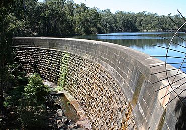
Masonry arch wall at Lake Parramatta
|
|||||||||||||||
| Population | 13,248 (2016 census) | ||||||||||||||
| • Density | 2,548/km2 (6,600/sq mi) | ||||||||||||||
| Postcode(s) | 2151 | ||||||||||||||
| Elevation | 39 m (128 ft) | ||||||||||||||
| Area | 5.2 km2 (2.0 sq mi) | ||||||||||||||
| Location | 24 km (15 mi) north-west of Sydney CBD | ||||||||||||||
| LGA(s) | City of Parramatta | ||||||||||||||
| State electorate(s) |
|
||||||||||||||
| Federal Division(s) | Parramatta | ||||||||||||||
|
|||||||||||||||
North Parramatta is a suburb in Sydney, New South Wales, Australia. It is located about 24 kilometres north-west of the main city area. North Parramatta is part of the City of Parramatta local government area.
Contents
A Glimpse into North Parramatta's Past
Long ago, the Darug people lived in this area. They saw it as a rich source of food. They found plenty of food from the river and forests. They called the area Baramada or Burramatta. This name means "the place where the eels lie down."
Protecting North Parramatta's History
North Parramatta has many special historical places. These are called heritage-listed sites. They are important buildings or areas that are protected.
Some of these sites include:
- Lake Parramatta at 28a Bourke Street
- Parramatta Correctional Centre at the corner of O'Connell Street and Dunlop Street
- St Patrick's Cemetery on Pennant Hills Road
A group called UrbanGrowth NSW Development Corporation is working to protect these old places. They are making sure the heritage buildings are repaired. This work helps keep them safe and protected from the weather. Important landmarks like the Cumberland Hospital and the Norma Parker Centre will be saved.
Schools and Fun in North Parramatta
A big part of North Parramatta is taken up by Lake Parramatta and The King's School. Together, they cover almost half of the land.
Lake Parramatta
Lake Parramatta is a large park area. It is built around an old water reservoir. The lake was once closed because of pollution. But it was cleaned up and reopened in January 2015. Now, local people can enjoy swimming there again. The entrance to the lake is from Lackey Street.
Schools in the Area
North Parramatta is home to several schools. These schools help educate many young people in the community.
Some of the schools here are:
- Burnside Public School
- Parramatta North Public School
- Redeemer Baptist School – this school is on a heritage-listed site
- RIDBC Garfield Barwick School
- Tara Anglican School for Girls
- The King's School, Parramatta, which is the oldest independent school in Australia
- St. Monica's Primary School
Getting Around North Parramatta
The closest train station for North Parramatta is Parramatta railway station. This station connects residents to other parts of Sydney.
For local travel, the 609 bus route is available. This bus route is run by Hillsbus. It travels around Prince Street, Gloucester Avenue, past Lake Parramatta, and to the Parramatta Bus Interchange.
In 2011, about 21.9% of people used public transport for work. Most people, about 57.3%, travelled by car.
Who Lives in North Parramatta?
In 2016, a survey counted 13,248 people living in North Parramatta.
Age Groups
North Parramatta has more young adults than the rest of Australia. About 20.4% of people are aged 25–34 years. The average age of residents here was 35 years old. This is a bit younger than the national average of 38 years. Children aged 0–14 years make up 17.7% of the population. People aged 65 years and over make up 11.0% of the population.
Different Backgrounds
About half of the people (45.4%) in North Parramatta were born in Australia. Many others come from different countries. The most common countries of birth after Australia are India, China, Iran, the Philippines, and Lebanon.
People also have diverse family backgrounds. The largest group identifies as Australian. Other common ancestries include English, Chinese, Indian, and Irish.
Languages Spoken
Just under half of the people (44.1%) speak only English at home. Many other languages are also spoken. These include Mandarin, Arabic, Persian, Cantonese, and Hindi.
Beliefs
The most common responses for religion were Catholic (23.7%) and No Religion (21.4%).
 | Selma Burke |
 | Pauline Powell Burns |
 | Frederick J. Brown |
 | Robert Blackburn |

