Terrell Hills, Texas facts for kids
Quick facts for kids
Terrell Hills, Texas
|
|
|---|---|

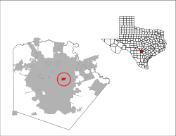
Location of Terrell Hills, Texas
|
|
| Country | |
| State | |
| County | Bexar |
| Government | |
| • Type | Council-Manager |
| Area | |
| • Total | 1.61 sq mi (4.18 km2) |
| • Land | 1.61 sq mi (4.18 km2) |
| • Water | 0.00 sq mi (0.00 km2) |
| Elevation | 801 ft (244 m) |
| Population
(2020)
|
|
| • Total | 5,045 |
| • Density | 3,379.03/sq mi (1,304.58/km2) |
| Time zone | UTC-6 (Central (CST)) |
| • Summer (DST) | UTC-5 (CDT) |
| ZIP code |
78209
|
| Area code(s) | 210, 726 (planned) |
| FIPS code | 48-72296 |
| GNIS feature ID | 1348382 |
| ANSI Code | 2412051 |
Terrell Hills is a city in Bexar County, Texas, United States. It is located about 5 miles (8 km) northeast of downtown San Antonio. In 2020, the city had a population of 5,045 people.
Contents
About Terrell Hills City
Terrell Hills is one of three cities in the area. The other two are Alamo Heights and Olmos Park. These cities are found between different parts of San Antonio and Fort Sam Houston, which is a U.S. Army base.
Terrell Hills is next to Alamo Heights on its west side. Fort Sam Houston is to its east. Uptown San Antonio is to the north, and San Antonio's Near East Side is to the south. The city is part of the larger San Antonio metropolitan area.
History of Terrell Hills
The city is named after Frederick Terrell. He was a local bank president and also served as the mayor of San Antonio in 1901. The city started to be built in 1919. That year, Frederick Terrell sold 22.5 acres of land. He sold it to a group called the Terrell Hills Community.
This group managed the community until 1939. Then, it officially became its own city. In 1945, the City of San Antonio tried to take over Terrell Hills. This is called annexation. San Antonio tried to do this without letting people vote on it. But Terrell Hills went to court and stopped the takeover.
City Geography
The United States Census Bureau says that Terrell Hills covers about 4.2 square kilometers (1.6 square miles). All of this area is land.
City Population Facts
|
||||||||||||||||||||||||||||||||||||||||||||||||
| Race | Number of People | Percentage |
|---|---|---|
| White (NH) | 3,841 | 76.13% |
| Black or African American (NH) | 42 | 0.83% |
| Native American (NH) | 12 | 0.24% |
| Asian (NH) | 81 | 1.61% |
| Pacific Islander (NH) | 1 | 0.02% |
| Some Other Race (NH) | 22 | 0.44% |
| Mixed/Multi-Racial (NH) | 159 | 3.15% |
| Hispanic or Latino | 887 | 17.58% |
| Total | 5,045 |
In 2020, there were 5,045 people living in Terrell Hills. There were 1,695 households and 1,314 families.
In 2000, the city had 5,019 residents. Most people, about 95.40%, identified as White. About 11.68% of the population identified as Hispanic, Latino, or Spanish origin.
The average household had 2.62 people. The average family had 3.09 people. About 28.2% of the city's population was under 18 years old. The median age in Terrell Hills was 42 years.
The median income for a household in the city was $79,295. The median income for a family was $86,636. About 4.7% of the city's population lived below the poverty line. This means they had very low incomes.
Education in Terrell Hills
Most students in Terrell Hills go to schools in the Alamo Heights Independent School District. These schools include:
- Howard Early Childhood Center in San Antonio
- Woodridge Elementary School in San Antonio
- Alamo Heights Junior High School in San Antonio
- Alamo Heights High School in Alamo Heights
A smaller part of Terrell Hills is served by the North East Independent School District. Students in this area attend:
- Wilshire Elementary School in San Antonio
- Garner Middle School in San Antonio
- MacArthur High School in San Antonio
Famous People from Terrell Hills
- Christopher Cross, a singer-songwriter who won Grammy awards.
- Tommy Lee Jones, an actor who won an Academy Award in 1993.
See also
 In Spanish: Terrell Hills (Texas) para niños
 | Georgia Louise Harris Brown |
 | Julian Abele |
 | Norma Merrick Sklarek |
 | William Sidney Pittman |

