
Texas–Gulf water resource region facts for kids
The Texas–Gulf water region is one of 21 big areas in the United States that help us understand where water flows. These areas are like giant natural bowls that collect water from rain and snow. They are used by the United States Geological Survey to study how water moves across the country. Each region includes the area where a major river flows, or where several rivers combine.
The Texas–Gulf region has a special code, 12, which helps scientists identify it. It's a huge area, about 181,886 square miles (471,080 km2). This region includes parts of Louisiana, New Mexico, and Texas. All the water in this region eventually flows into the Gulf of Mexico. This includes water from places like Sabine Pass all the way to the Rio Grande area.

Understanding the Texas–Gulf Water Region
The Texas–Gulf water region is divided into smaller parts called subregions. Think of these as smaller bowls within the big bowl. There are 11 of these subregions, each with its own special code from 1201 to 1211. Each subregion covers a specific area where water drains into a particular river or bay.
Why are these subregions important?
These subregions help experts manage water resources better. By dividing the land into smaller, more manageable parts, it's easier to:
- Understand how much water is available.
- Protect water quality.
- Plan for floods or droughts.
- Study how human activities affect rivers and lakes.
Meet the Texas–Gulf Subregions
Let's take a closer look at some of the main water subregions in the Texas–Gulf area. Each one has a unique name and covers a specific part of the landscape.
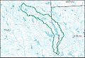
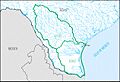
Sabine Subregion (1201)
This subregion covers the area where the Sabine River flows, before it reaches Sabine Lake. It's located in both Louisiana and Texas. It's about 9,860 sq mi (25,500 km2).
Neches Subregion (1202)
The Neches subregion includes the Neches River basin, which also flows towards Sabine Lake. This area is entirely within Texas and is about 10,000 sq mi (26,000 km2).
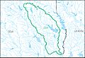
Trinity Subregion (1203)
This subregion is home to the Trinity River basin, which flows into Trinity Bay. It's located in Texas and covers about 18,000 sq mi (47,000 km2).
Galveston Bay–San Jacinto Subregion (1204)
This area includes the coastal lands and waters from Sabine Pass to the Brazos River. It does not include the Sabine, Neches, or Trinity River basins. This subregion is found in Louisiana and Texas and is about 7,980 sq mi (20,700 km2).
Brazos River Subregions (1205, 1206, 1207)
The Brazos River is so big that its basin is split into three subregions:
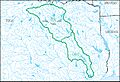
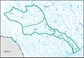
- Brazos Headwaters (1205): This is the upper part of the Brazos River basin, including where the Double Mountain Fork and Salt Fork Brazos Rivers meet. It's in New Mexico and Texas, covering about 14,600 sq mi (38,000 km2).
- Middle Brazos (1206): This section of the Brazos River basin is below where the two forks meet, down to the Castleman Creek Basin. It's in Texas and is about 15,500 sq mi (40,000 km2).
- Lower Brazos (1207): This is the lowest part of the Brazos River basin, below the Castleman Creek Basin. It's in Texas and is about 15,600 sq mi (40,000 km2).
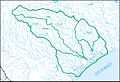
Colorado River Subregions (1208, 1209)
The Colorado River basin in Texas is also divided:
- Upper Colorado (1208): This part of the Colorado River basin includes the Oak Creek Basin. It's found in New Mexico and Texas, covering about 16,000 sq mi (41,000 km2).
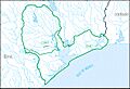
- Lower Colorado–San Bernard Coastal (1209): This subregion includes the Colorado River basin below the Oak Creek Basin. It also covers the coastal areas from the Brazos River to the Colorado River. This area is in Texas and is about 28,400 sq mi (74,000 km2).
Central Texas Coastal Subregion (1210)
This subregion includes the coastal areas and waters from the Colorado River to Aransas Pass and Corpus Christi Bay. It's located in Texas and covers about 18,200 sq mi (47,000 km2).
Nueces–Southwestern Texas Coastal Subregion (1211)
This subregion covers the coastal areas and waters from Aransas Pass, including Corpus Christi Bay and the Nueces River area, all the way to the Rio Grande. It's in Texas and is about 29,000 sq mi (75,000 km2).
Images for kids
-
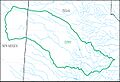
Map of the Sabine subregion
-
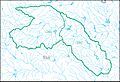
Map of the Neches subregion
-
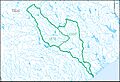
Map of the Trinity subregion
-
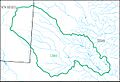
Map of the Galveston Bay–San Jacinto subregion
-
Map of the Brazos headwaters subregion
-
Map of the Middle Brazos subregion
-
Map of the Lower Brazos subregion
-
Map of the Upper Colorado subregion
-
Map of the Lower Colorado–San Bernard Coastal subregion
-
Map of the Central Texas Coastal subregion
-
Map of the Nueces–Southwestern Texas Coastal subregion


