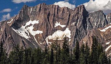
The Lieutenants facts for kids
Quick facts for kids The Lieutenants |
|
|---|---|

The Lieutenants, south aspect
|
|
| Highest point | |
| Elevation | 3,270 m (10,730 ft) |
| Prominence | 722 m (2,369 ft) |
| Geography | |
| Location | British Columbia, Canada |
| Parent range | Purcell Mountains |
| Topo map | NTS 82K/7 |
The Lieutenants are a group of tall peaks found in the Purcell Mountains. These mountains are located in the southeastern part of British Columbia, Canada. They stand very high, reaching an elevation of 3,270 meters (about 10,730 feet) above sea level.
The Lieutenants are about 40 kilometers (25 miles) west of a town called Invermere. They are also near the border of the Jumbo Glacier Mountain Resort Municipality. The closest taller mountain is Karnak Mountain, which is about 2 kilometers (1.2 miles) to the southeast. Another nearby peak, Commander Mountain, is about 2.12 kilometers (1.3 miles) to the east.
Naming the Mountains
The name "The Lieutenants" was officially chosen for these peaks on July 17, 1962. This decision was made and approved by the Geographical Names Board of Canada.
Mountain Climate
The Lieutenants are in a subarctic climate zone. This type of climate has very cold and snowy winters. The summers are usually mild. Temperatures can often drop below −20 °C (which is −4 °F). With the wind, it can feel even colder, sometimes below −30 °C (which is −22 °F).
Water Flow
When snow melts or rain falls on the mountain, the water flows down. This water then drains into the beginnings of Jumbo Creek and Horsethief Creek. Both of these creeks eventually flow into the much larger Columbia River.
 | Anna J. Cooper |
 | Mary McLeod Bethune |
 | Lillie Mae Bradford |


