
The Loop (Tucson) facts for kids
Quick facts for kids The Loop |
|
|---|---|
| Shared-use path network | |
| Details | |
| Location | Metropolitan Tucson, Arizona |
| Operated by | Pima County, Arizona |
| Usage | Cycling, walking, horseback riding |
| Length | 120 mi (current) 131 mi (planned) |
| Surface | Asphalt (primary) Parallel natural and asphalt paths |
| Website | The Loop |
| System Map | |
The Loop is a big network of trails in Tucson, Arizona. These trails are for everyone to share! They are managed by Pima County.
When finished, The Loop will have 131 miles of paved paths. These paths are perfect for biking, walking, and even horseback riding. By 2014, most of the network was already built. Over 100 miles were ready to use! Pima County estimates that about 2,000 people use The Loop on weekdays. On weekends, more than 5,000 people enjoy the trails.
Contents
What Makes The Loop Special?
Most of The Loop's trails follow the Santa Cruz River or its smaller streams. Even though these rivers are often dry, they have water underground. This water helps many animals and plants live there.
A cool thing about these trails is that they go under bridges. This means you can keep going without stopping for cars! Many starting points for the trails have helpful things. You can find bathrooms, water fountains, and shady spots. There are also benches to rest on and parking for your car. If you ride horses, there are special parking spots for horse trailers. Some parts of the trail even have a natural path next to the paved one, just for horses.
Exploring The Loop's Trails
The Loop has several different sections, each with its own unique path.
Santa Cruz River Park Trail
The Santa Cruz River Park trail goes from north to south. It passes right through downtown Tucson. By 2014, this park had over 40 miles of paved paths. More miles were being planned or built.
A 1.5-mile section called Paseo de las Iglesias was finished in 2015. Its name means "the path between churches." This part helped connect the trail to the Julian Wash Greenway. In 2016, the Midvale Park section was added. This made the path over 22 miles long, stretching from Valencia to Marana. Work to extend the park even further north started in 2017.
Rillito River Park Trail
The Rillito River Park trail is one of the busiest parts of The Loop. It runs east to west along the northern edge of Tucson. This trail follows the Rillito River, which is the biggest stream flowing into the Santa Cruz River.
The Rillito River Park has paths on both sides of the river for most of its length. It stretches for 12 miles from where it meets the Santa Cruz River to Craycroft. At Craycroft, the river splits into the Tanque Verde and Pantano streams. This park has more than 25 miles of paved trails.
Julian Wash Greenway Trail
The Julian Wash Greenway connects to the Santa Cruz River Park. It runs southeast, next to Interstate 10, all the way to Rita Ranch. This park was completed in 2014. It has 16.1 miles of paved trails for you to explore.
Pantano River Park Trail
The Pantano River Park trail was the last part to be finished. It completed a continuous loop around the city of Tucson. This trail now runs from the Rillito trail at Craycroft Road. It goes south-southeast to the Harrison Greenway connection at Sellarole Road.

Harrison Greenway Trail
The Harrison Greenway is special because it doesn't follow a river. It connects the Pantano River Park and the Julian Wash Greenway. This trail runs next to Harrison Road for 1.3 miles. From there, it continues south through the desert. It crosses Valencia Road and then goes through a neighborhood to Rita Road. A 1.5-mile section uses bike lanes on Rita Road. This leads to the eastern end of the Julian Wash Greenway.
Cañada del Oro River Park Trail
The Cañada del Oro River Park trail goes northeast from the Santa Cruz Park. It passes through Casas Adobes and into Oro Valley. This is one of two main trails that go north from where the Santa Cruz and Rillito River Parks meet. The other is the Santa Cruz River Park itself, which goes northwest through Marana and south to Valencia Road. A new 1.6-mile section was planned to be finished in 2017. This would make the Cañada del Oro trail 7.3 miles long.
Images for kids
-
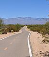
Looking north along the Harrison Greenway, a connecting trail in The Loop.
