The Street (Derbyshire) facts for kids
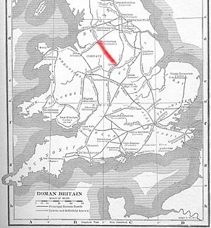
The Street is the old name for a Roman road in central Derbyshire, England. This ancient road stretched across the high limestone hills from the spa town of Buxton (which the Romans called Aquae Arnemetiae) southeast towards modern Derby.
You can still find parts of this road today. Experts have used old maps, visible features, and archaeological digs to trace its path. From Buxton, it went as far as Longcliffe, just north of Brassington. From Brassington, it likely went east to Wirksworth. There, it probably joined another Roman road. This second road crossed the River Derwent at Milford. It then followed the east bank of the river to the northern parts of Derby. This led to Little Chester, which was the Roman settlement of Derventio.
Old maps from 1723 show "The Street" going from Buxton through Pikehall. It then continued towards Wirksworth, which might have been a Roman town called Lutudarum. Records from 1613 even call the road from Brassington to Wirksworth the 'Highe Streete'.
Contents
Why the Romans Built Roads
The Romans were very good at building roads. They built them for their armies to move quickly. They also used them to transport goods and connect their towns. Along "The Street," the Romans built farms. These farms helped feed the soldiers and the people living in the area.
Finding Roman Farms
Near a place called Minninglow, archaeologists found the remains of a Roman farm. In 1958, a researcher named Lomas dug there. He found the layered structure of the Roman road itself. This structure is called an agger. It shows how carefully the Romans built their roads.
Old Names for the Road
The road has been known by different names over time. In 1533, it was called 'Streete Way' in an old document. Even today, you can find many places with names related to "The Street" on maps. These include Street Farm, Street House Farm, Middle Street Farm, and Straight (Street) Knolls Barn. Some very old documents from 963 AD and around 1223 suggest that "The Street" was once known as King Street.
The Street's Official Number
In the 1950s, a historian named Ivan Margary studied Roman roads in Britain. He gave "The Street" an official number: 71. This number covers the road from Little Chester, through Buxton, all the way to Manchester. You can find this information in his book, The Roman Roads of Britain.
A Special Plaque
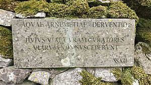
Near a place called Arbor Low, there is a stone wall by "The Street." On this wall, you can find a plaque with a Latin message. It says: "Huius viae curam curatores viarum non susceperunt". This means: "The road menders have not taken care of this road." It's a bit of a funny message, suggesting the road was not well maintained at some point!
The Road Continues North
"The Street" didn't just go south from Buxton. Northwest of Buxton, the road that goes west of the Upper Goyt Valley is also called "The Street."
Finding the Northern Route
In 1970, experts found the path of the Roman road north from Buxton. This part of the road went towards Melandra fort, which is near Glossop. They found the agger (the raised part) of a Roman road. This confirmed what another researcher, Turner, had observed in 1903. This northern section runs straight north to Dove Holes. It starts from where the Batham Gate Roman road meets the A6 road.
During this research, six other parts of the road were found and dug up. This helped map the route clearly. It showed the road running through Chapel-en-le-Frith, Chapel Minton, Hayfield, and up to Cown Edge. This path brought the road to within about three miles of Melandra fort.
 | Delilah Pierce |
 | Gordon Parks |
 | Augusta Savage |
 | Charles Ethan Porter |


