Lutudarum facts for kids
Lutudarum was an important town in Roman Britain, a province of the Roman Empire. It was located in the area we now call mid-Derbyshire, England. Experts believe the settlement was either at Wirksworth or nearby Carsington. Other possible locations include Matlock and Cromford.
Contents
Lutudarum: A Roman Town
The town was mentioned as Lutudaron in an old list of places from about 700 AD. This list, called the Ravenna Cosmography, placed Lutudarum between Derventio (modern Derby) and Veratino (Rocester).
Why Was Lead Important?
Derbyshire was very important for mining lead during Roman times. The Romans used lead for many things. This included water pipes, large water tanks called cisterns, coffins, and weights. They also used it to make pewter tableware.
Clues from Lead Ingots
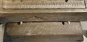
Many large blocks of lead, called "pigs," have been found in Derbyshire. These ingots often had marks on them. For example, four lead pigs found in Sussex in 1824 had LVT, LVTVM, or LVTVDARVM marked on them. These marks came from the clay moulds used to shape the lead.
In 1777, a lead pig found at Cromford had a special message. It read IMP CAES HADRIANI AVG MET LVT. This means 'Property of Caesar Hadrian Augustus from the Lutudarum mines'. This shows the lead came from Lutudarum.
Another large lead ingot, weighing over 80 kg, was found in 1848. It was marked C.IVL.PROTI.BRIT.LVT.EX.ARG. In 1975, two more lead pigs were found near Yeaveley. They were marked SOCORIVM LVTVD, meaning 'the Lutudarium Company'.
Where Did the Lead Go?
The lead pigs found near Hull suggest how the lead was moved. It's thought the lead was sent by boat from Derbyshire. It would travel down the River Trent and then the Humber river. From there, it went to the Roman port of Peturia (Brough on Humber). From Brough, the lead could be shipped by sea to other places.
The name Lutudarum might come from an old British word, Lud. This word meant 'ashes'. This could refer to the piles of waste left over from making lead.
Finding Lutudarum Today
Lutudarum is known as the main control center for Roman lead mining in Britain. Researchers have looked for its exact location in the White Peak area of the Peak District. They have focused on sites at Wirksworth and Carsington.
Two Roman roads met in this area. One was The Street from Aquae Arnemetiae (Buxton). The other was The Portway road from Navio Roman fort (at Brough).
Digging Up Carsington
In the 1980s, archaeologists dug up parts of Carsington. They found remains of a Roman settlement. This included what looked like a large farm or villa. They also found other buildings and various Roman items. Two lead pigs, each weighing about 50 kg, were also discovered. You can see copies of these lead ingots in the Buxton Museum.
Evidence of lead working was also found at Carsington. This included small pieces of lead sheets and lead slag. They also found pits containing galena ore, which is the raw material for lead. Sadly, this settlement was permanently covered by the Carsington Water reservoir in 1992.
Wirksworth: Another Clue?
No Roman buildings have been found in Wirksworth itself. However, in 1735, a collection of Roman coins was found there. This collection was known as the 'hoard of the five emperors'. Wirksworth was also an important local center in the Middle Ages. It is likely where several Roman roads met.
In 1086, the Domesday Book recorded Wirksworth. It had a church, three lead works, and was the largest market town in the Peak District at that time. Old maps and records also show Roman roads leading to Wirksworth. For example, a 1723 map shows The Street road from Buxton leading towards Wirksworth. In 1613, the road from Brassington to Wirksworth was called 'Highe Streete'.
The Mystery Continues
Even with all these clues, the exact location of Lutudarum remains a bit of a mystery. But the evidence points to this area being very important for the Romans and their lead mining.
See also
 In Spanish: Lutudarum para niños
 | Bessie Coleman |
 | Spann Watson |
 | Jill E. Brown |
 | Sherman W. White |


