Thermalito, California facts for kids
Quick facts for kids
Thermalito
|
|
|---|---|

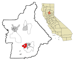
Location in Butte County and the state of California
|
|
| Country | |
| State | |
| County | Butte |
| Area | |
| • Total | 12.870 sq mi (33.332 km2) |
| • Land | 12.702 sq mi (32.898 km2) |
| • Water | 0.168 sq mi (0.434 km2) 1.30% |
| Elevation | 223 ft (68 m) |
| Population
(2020)
|
|
| • Total | 7,198 |
| • Density | 559.29/sq mi (215.949/km2) |
| Time zone | UTC-8 (Pacific) |
| • Summer (DST) | UTC-7 (PDT) |
| ZIP code |
95965
|
| Area code | 530 |
| FIPS code | 06-78470 |
| GNIS feature ID | 1659991 |
Thermalito is a place in Butte County, California, United States. It is known as a "census-designated place" (CDP). This means it's an area that looks like a town but doesn't have its own city government. The name "Thermalito" comes from Spanish and means "Small Thermal."
Thermalito is very close to the city of Oroville. It borders Oroville on two sides. There's even a small part of Oroville that is almost completely surrounded by Thermalito. In 2020, about 7,198 people lived there.
Contents
Geography and Climate
Thermalito covers an area of about 12.87 square miles (33.33 square kilometers). Most of this area is land. A small part, about 0.168 square miles (0.434 square kilometers), is water.
Climate in Thermalito
Thermalito has a type of weather called a warm-summer Mediterranean climate. This means it has hot, dry summers and mild, wet winters. You might see this climate type called "Csa" on climate maps.
Thermalito Trail
The Thermalito Trail is a path located in Thermalito. It goes through a place called the Kilkare Canyon. It's a great spot for outdoor activities.
History of Thermalito
Thermalito had a post office for many years. It was open from 1895 until 1920. This shows that people have lived and worked in the area for a long time.
People of Thermalito
Let's look at who lives in Thermalito.
Population in 2010
In 2010, the population of Thermalito was 6,646 people. Most people lived in homes, while a small number lived in group housing or institutions.
The people living in Thermalito came from different backgrounds:
- About 69.1% were White.
- About 0.9% were African American.
- About 3.9% were Native American.
- About 16.6% were Asian.
- About 0.6% were Pacific Islander.
- About 4.1% were from other races.
- About 4.9% were from two or more races.
- About 10.7% of the people were Hispanic or Latino.
There were 2,263 households in Thermalito. About 35.1% of these households had children under 18 living there. The average household had about 2.90 people. The average family size was 3.44 people.
The median age of people in Thermalito was 37.0 years old. This means half the people were younger than 37, and half were older.
Population in 2000
In 2000, there were 6,045 people living in Thermalito. There were 2,143 households.
The racial makeup of the area in 2000 was:
- 77.73% White
- 0.46% Black or African American
- 2.91% Native American
- 10.50% Asian
- 0.20% Pacific Islander
- 2.98% from other races
- 5.21% from two or more races
- 7.69% of the population were Hispanic or Latino.
The median age in 2000 was 37 years.
Most high school students in Thermalito go to Oroville High School.
See also
 In Spanish: Thermalito para niños
 | Percy Lavon Julian |
 | Katherine Johnson |
 | George Washington Carver |
 | Annie Easley |


