Thomaston (CDP), Maine facts for kids
Quick facts for kids
Thomaston, Maine
|
|
|---|---|

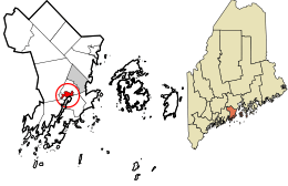
Location in Knox County and the state of Maine
|
|
| Country | United States |
| State | Maine |
| County | Knox |
| Town | Thomaston |
| Area | |
| • Total | 2.16 sq mi (5.60 km2) |
| • Land | 2.12 sq mi (5.48 km2) |
| • Water | 0.04 sq mi (0.11 km2) |
| Elevation | 118 ft (36 m) |
| Population
(2020)
|
|
| • Total | 1,836 |
| • Density | 867.67/sq mi (335.00/km2) |
| Time zone | UTC-5 (Eastern (EST)) |
| • Summer (DST) | UTC-4 (EDT) |
| ZIP code |
04861
|
| Area code(s) | 207 |
| FIPS code | 23-76330 |
| GNIS feature ID | 0576993 |
Thomaston is a small community in Knox County, Maine, United States. It is known as a "census-designated place" (CDP). This means it is a specific area that the government counts for population. In 2010, about 1,875 people lived here. The whole town of Thomaston had 2,781 residents.
Contents
Exploring Thomaston's Location
Thomaston is located in the southern part of the larger town of Thomaston. It sits on the north side of the Saint George River. This is where the river meets the ocean's tides.
Getting Around Thomaston
U.S. Route 1 is the main road through the village. It is called Main Street. This road goes northeast about 4 miles (6.4 km) to Rockland. It also goes northwest about 5 miles (8 km) to Warren.
Maine State Route 131 also follows Route 1 on Main Street. However, it then turns northwest onto Oyster River Road. This road leads to the eastern part of Warren. Route 131 also goes south on High Street for five miles (8 km) to St. George.
Thomaston's Size and Water Areas
The Thomaston CDP covers a total area of about 2.16 square miles (5.6 square kilometers). Most of this area, about 2.12 square miles (5.5 square kilometers), is land. The rest, about 0.04 square miles (0.1 square kilometers), is water. This means about 1.98% of Thomaston is covered by water.
Thomaston's Population and People
| Historical population | |||
|---|---|---|---|
| Census | Pop. | %± | |
| 2020 | 1,836 | — | |
| U.S. Decennial Census | |||
In 2000, there were 2,714 people living in Thomaston. These people lived in 1,013 households. About 583 of these were families. The population density was about 1,379 people per square mile (532 people per square kilometer). There were also 1,100 housing units.
Diversity in Thomaston
Most of the people in Thomaston were White (97.13%). Other groups included Black (0.81%), Native American (0.29%), and Asian (0.66%). A small number of people were from other backgrounds. About 0.55% of the population was Hispanic or Latino.
Households and Families
About 25.5% of households had children under 18 living with them. Many households (43.3%) were married couples living together. About 10.2% of households had a female head with no husband present. Around 35.7% of all households were made up of people living alone. About 18.8% of these were people aged 65 or older living by themselves. The average household had 2.25 people, and the average family had 2.90 people.
Age Groups in Thomaston
The population in Thomaston was spread across different age groups:
- 18.6% were under 18 years old.
- 9.0% were between 18 and 24 years old.
- 31.9% were between 25 and 44 years old.
- 24.7% were between 45 and 64 years old.
- 15.8% were 65 years or older.
The median age in Thomaston was 39 years. This means half the people were younger than 39 and half were older. For every 100 females, there were about 121.7 males. For females aged 18 and over, there were about 127.6 males for every 100 females.
See also
 In Spanish: Thomaston (condado de Knox) para niños
 | Frances Mary Albrier |
 | Whitney Young |
 | Muhammad Ali |

