
Knox County, Maine facts for kids
Quick facts for kids
Knox County
|
|
|---|---|

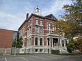
Knox County Courthouse
|
|

Location within the U.S. state of Maine
|
|
 Maine's location within the U.S. |
|
| Country | |
| State | |
| Founded | April 1, 1860 |
| Named for | Henry Knox |
| Seat | Rockland |
| Largest city | Rockland |
| Area | |
| • Total | 1,144 sq mi (2,960 km2) |
| • Land | 365 sq mi (950 km2) |
| • Water | 779 sq mi (2,020 km2) 68%% |
| Population
(2020)
|
|
| • Total | 40,607 |
| • Density | 35.496/sq mi (13.705/km2) |
| Time zone | UTC−5 (Eastern) |
| • Summer (DST) | UTC−4 (EDT) |
| Congressional district | 1st |
Knox County is a special area in the state of Maine, United States. It's called a county. In 2020, about 40,607 people lived here.
The main town, or county seat, of Knox County is Rockland. The county is named after Henry Knox. He was a famous general during the American Revolutionary War and later became the first United States Secretary of War. Henry Knox lived in this area from 1795 until he passed away in 1806.
Knox County was officially created on April 1, 1860. It is the newest county in Maine. It was made from parts of two other counties: Waldo County and Lincoln County. A fun event called the Union Fair started here in 1868. It began with efforts from a local farming and gardening group.
Contents
Geography of Knox County
Knox County covers a total area of about 1,144 square miles. A big part of this area is water, about 779 square miles. The land area is about 365 square miles. This means about 68% of the county is water! It is the second-smallest county in Maine when you only look at its land area.
Neighboring Counties
Knox County shares its borders with these other counties:
- Lincoln County to the west
- Waldo County to the north
- Hancock County to the northeast
Protected Natural Areas
Knox County is home to some special places where nature is protected:
Population of Knox County
| Historical population | |||
|---|---|---|---|
| Census | Pop. | %± | |
| 1860 | 32,716 | — | |
| 1870 | 30,823 | −5.8% | |
| 1880 | 32,863 | 6.6% | |
| 1890 | 31,473 | −4.2% | |
| 1900 | 30,406 | −3.4% | |
| 1910 | 28,981 | −4.7% | |
| 1920 | 26,245 | −9.4% | |
| 1930 | 27,693 | 5.5% | |
| 1940 | 27,191 | −1.8% | |
| 1950 | 28,121 | 3.4% | |
| 1960 | 28,575 | 1.6% | |
| 1970 | 29,013 | 1.5% | |
| 1980 | 32,941 | 13.5% | |
| 1990 | 36,310 | 10.2% | |
| 2000 | 39,618 | 9.1% | |
| 2010 | 39,736 | 0.3% | |
| 2020 | 40,607 | 2.2% | |
| 2023 (est.) | 40,977 | 3.1% | |
| U.S. Decennial Census 1790–1960 1900–1990 1990–2000 2010–2016 |
|||
In 2010, there were 39,736 people living in Knox County. The population density was about 108 people per square mile of land. The average age of people living here was about 46 years old.
Communities in Knox County
Knox County has one city and many towns and other small communities.
City
- Rockland (This is the county seat, where the main government offices are.)
Towns
Plantation
Unorganized Territories
These are areas that don't have their own local government:
- Criehaven
- Muscle Ridge Islands
Census-Designated Places
These are special areas defined for gathering census information:
Other Small Villages
Public Buildings
The Knox County Courthouse is an important building in the county. A new part was added to it in 2005. This new part connects to an older annex building from 1977. The very first courthouse building was finished in 1874.
Images for kids
-
Knox County Courthouse
See also
 In Spanish: Condado de Knox (Maine) para niños
