Knox, Maine facts for kids
Quick facts for kids
Knox, Maine
|
|
|---|---|

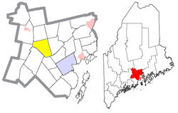
Location of Knox (in yellow) in Waldo County and the state of Maine
|
|
| Country | United States |
| State | Maine |
| County | Waldo |
| Area | |
| • Total | 29.17 sq mi (75.55 km2) |
| • Land | 28.97 sq mi (75.03 km2) |
| • Water | 0.20 sq mi (0.52 km2) |
| Elevation | 794 ft (242 m) |
| Population
(2020)
|
|
| • Total | 811 |
| • Density | 28/sq mi (10.8/km2) |
| Time zone | UTC-5 (Eastern (EST)) |
| • Summer (DST) | UTC-4 (EDT) |
| ZIP code |
04986
|
| Area code(s) | 207 |
| FIPS code | 23-37585 |
| GNIS feature ID | 0582545 |
| Website | Town of Knox |
Knox is a small town located in Waldo County, Maine, in the United States. It's called a 'New England town' because of its history and how it's set up. The town got its name from General Henry Knox, who was a very important leader and the first person to hold the job of Secretary of War for the U.S. Its population was 811 people when the 2020 census was taken.
Contents
Knox, Maine: Land and Water
Knox is a town with a mix of land and water. Most of its area is land, about 28.97 square miles (75.03 square kilometers). A small part, about 0.20 square miles (0.52 square kilometers), is water.
Rivers and Ponds in Knox
Two main streams flow through the town: Marsh Stream and Halfmoon Stream. Knox also has two notable ponds: Mixer Pond, which is 48 acres, and Dutton Pond, which is 41 acres.
Roads and Neighbors
Several state roads pass through Knox. These include Route 137, Route 220, and Route 139. Knox shares its borders with several other towns. To the north is Thorndike, and to the east is Brooks. Morrill is to the southeast, while Montville is to the southwest. To the west is Freedom, and to the northwest is Unity.
Frye Mountain Wildlife Area
A part of the Frye Mountain Wildlife Management Area is located in Knox. This area is important for protecting wildlife and their natural homes.
People of Knox: Demographics
The population of Knox has changed over many years. Here is a quick look at how the number of people living in the town has grown or shrunk over time:
| Historical population | |||
|---|---|---|---|
| Census | Pop. | %± | |
| 1810 | 414 | — | |
| 1820 | 560 | 35.3% | |
| 1830 | 666 | 18.9% | |
| 1840 | 897 | 34.7% | |
| 1850 | 1,102 | 22.9% | |
| 1860 | 1,074 | −2.5% | |
| 1870 | 889 | −17.2% | |
| 1880 | 852 | −4.2% | |
| 1890 | 657 | −22.9% | |
| 1900 | 558 | −15.1% | |
| 1910 | 511 | −8.4% | |
| 1920 | 532 | 4.1% | |
| 1930 | 509 | −4.3% | |
| 1940 | 471 | −7.5% | |
| 1950 | 445 | −5.5% | |
| 1960 | 439 | −1.3% | |
| 1970 | 443 | 0.9% | |
| 1980 | 558 | 26.0% | |
| 1990 | 681 | 22.0% | |
| 2000 | 747 | 9.7% | |
| 2010 | 806 | 7.9% | |
| 2020 | 811 | 0.6% | |
| U.S. Decennial Census | |||
Knox Population in 2010
In 2010, there were 806 people living in Knox. These people lived in 313 households, and 223 of these were families. Most of the people in Knox were White (96.7%). A smaller number were Asian (1.4%), Pacific Islander (0.2%), or from other races (1.0%). About 0.7% of the population identified as being from two or more races. About 1.0% of the population was Hispanic or Latino.
Households and Families
Out of all the households, about 35.5% had children under 18 living there. More than half (55.3%) were married couples living together. Some households had a female head without a husband (9.9%) or a male head without a wife (6.1%). About 20.1% of households were made up of people living alone. Of these, 9.3% were people aged 65 or older living by themselves. The average number of people in a household was 2.58, and the average family had 2.91 people.
Age in Knox
The average age of people in Knox in 2010 was 39.6 years old. About 23.1% of the residents were under 18 years old. About 8% were between 18 and 24 years old. The largest group, 30.6%, was between 45 and 64 years old. About 12% of the population was 65 years old or older. Slightly more than half of the population (51.2%) was female, and 48.8% was male.
Education in Knox
Knox is part of a school district called Regional School Unit No. 3. This district includes several schools for students of different ages.
Schools in the District
The school district has six elementary schools, which are for younger students. There is also one middle school and one high school for older students.
School Leadership
The person in charge of all the schools in the district is the Superintendent of Schools. In 2023, Charles Brown held this position.
See also
 In Spanish: Knox (Maine) para niños
 | Kyle Baker |
 | Joseph Yoakum |
 | Laura Wheeler Waring |
 | Henry Ossawa Tanner |

