
Thomaston, Maine facts for kids
Quick facts for kids
Thomaston, Maine
|
|
|---|---|

Downtown Thomaston in March 2013
|
|

Location of Thomaston in Knox County, Maine (left) and the state of Maine (right)
|
|
| Country | United States |
| State | Maine |
| County | Knox |
| Villages | Thomaston Wiley Corners |
| Area | |
| • Total | 11.48 sq mi (29.73 km2) |
| • Land | 10.94 sq mi (28.33 km2) |
| • Water | 0.54 sq mi (1.40 km2) |
| Population
(2020)
|
|
| • Total | 2,739 |
| • Density | 250/sq mi (96.7/km2) |
| Time zone | UTC-5 (Eastern (EST)) |
| • Summer (DST) | UTC-4 (EDT) |
| ZIP Code |
04861
|
| Area code(s) | 207 |
Thomaston is a small town in Knox County, Maine, United States. It used to be called Fort St. Georges, Fort Wharf, and Lincoln. In 2020, about 2,739 people lived there.
Thomaston is famous for its old buildings and is a popular spot for tourists. It was once a busy port. The town is named after Major General John Thomas.
Contents
History of Thomaston
Early Settlements and Fort St. George
As far back as 1630, a trading post was set up on the east side of the St. George River. This river was seen as the border between New England (English territory) and New France (French territory).
In 1704, a man named Thomas LeFebvre from Quebec bought a large piece of land. It was along the Weskeag River. He built a gristmill (a mill for grinding grain) and a house. This area later became known as Thomas' Town.
Around 1719–1720, the old trading post was turned into Fort St. George. This was a stockade fort, meaning it had strong walls made of logs. It was protected by two blockhouses (small forts).
Conflicts with Native American Tribes
Abenaki Indian tribes were not happy about the English fort being built on their land. The French encouraged them. The tribes attacked the fort's soldiers twice in 1722 during a conflict called Dummer's War. They attacked again in 1723, laying siege to the fort for 30 days. In response, soldiers destroyed the Abenaki stronghold of Norridgewock in 1724.
During the French and Indian War, there was more fighting. On August 13, 1758, a French officer named Boishebert led 400 soldiers from Miramichi, New Brunswick towards Fort St. George. They arrived on September 9 but were ambushed and had to leave. This was the last time Boishebert led an expedition in this area. His group then raided Friendship, Maine, where people were killed or captured. The fighting ended in 1759 after the Battle of the Plains of Abraham.
Growth and Industry
The first person to settle permanently in Thomaston was Mason Wheaton in 1763. Thomaston officially became a town on March 20, 1777. Many new settlers arrived after the Revolutionary War ended in 1783.
A famous general, Henry Knox, built his large home called Montpelier in Thomaston between 1793 and 1794.
The town grew quickly in the early 1800s. It was a busy port and a major center for building ships. Around 1840, two of the seven richest people in the United States were Thomaston sea captains!
Other businesses in Thomaston included:
- Two gristmills
- Two sawmills and planing mills
- Three places to make sails
- Brickyards
- Places to make casks (wooden barrels)
- A marble works (for cutting and shaping marble)
People had been making lime here since 1734 using special kilns (ovens). Today, Thomaston is still home to Jeff's Marine, Inc. and Lyman Morse Boatbuilding. These companies build custom power and sailing yachts. Lyman Morse Boatbuilding is on the St. George River, where wooden schooners have been built for over 200 years.
Later Developments
In 1848, the towns of Rockland and South Thomaston were created from parts of Thomaston. The Knox and Lincoln Railroad later came through Thomaston, carrying goods and tourists.
Thomaston was home to the state prison until 2002. The prison then moved to Warren, and the old building was torn down. The prison was known for its shop, which sold items made by the prisoners. This gift shop still exists today. The land for the prison was sold to the state in 1824 by a former governor, William King.
Today, Thomaston is a popular place for visitors. It has a large historic district with beautiful old buildings. These buildings show styles like Federal, Greek Revival, and Italianate architecture. The town was even a filming location for the 1996 movie, Thinner.
The Thomaston Historic District is listed on the National Register of Historic Places. This means it's a special place worth protecting.
Geography and Location
Thomaston covers about 11.48 square miles (29.73 square kilometers). Most of this is land, with a small part being water. The town has several rivers flowing through it, including the St. George River, Weskeag River, Mill River, and Oyster River.
The main roads that go through Thomaston are U. S. Route 1 and Maine State Route 131. Thomaston is next to Rockland to the northeast, South Thomaston to the south, Cushing to the southwest, and Warren to the northwest.
Population and People
In 2010, there were 2,781 people living in Thomaston. There were 1,219 households, which are groups of people living together. About 767 of these were families.
The people living in Thomaston were mostly White (97.0%). A small number were African American, Native American, or Asian. Some people were also from two or more races. About 0.5% of the population was Hispanic or Latino.
In 2010, the average age in Thomaston was 44 years old.
- 21.1% of residents were under 18.
- 6.7% were between 18 and 24.
- 23.4% were between 25 and 44.
- 30.8% were between 45 and 64.
- 18.1% were 65 or older.
There were slightly more females (53.1%) than males (46.9%) in the town.
Fire Department
The Thomaston Fire Department is made up entirely of volunteers. They have several vehicles to help the community:
- Three pumpers (fire trucks with pumps)
- One ladder truck with a 75-foot aerial ladder
- One utility/brush truck (for smaller fires or tasks)
- One ambulance
Places to Visit
- Maine Watercraft Museum: Learn about boats and water vehicles.
- Montpelier – General Henry Knox Museum: Visit the recreated home of General Henry Knox.
- Thomaston Historical Society & Museum: Discover the history of Thomaston.
Famous People from Thomaston

Many interesting people have come from Thomaston, including:
- Laura Bonarrigo, an actress
- Adelyn Bushnell, an author
- Jonathan Cilley, a U.S. Congressman
- Benjamin S. Deane, an architect
- Nathan A. Farwell, a businessman and U.S. Senator
- Anna Parker Fessenden, a botanist and math teacher
- Samuel C. Fessenden, a pastor and U.S. Congressman
- Charles Ranlett Flint, a businessman who helped start IBM
- Henry Knox, a general and the first U.S. Secretary of War
- Norman Wallace Lermond, a political activist and naturalist
- Joshua A. Lowell, a U.S. Congressman
- Charles Copeland Morse, a businessman
- Chris Rector, a Maine state senator
- Edward Robinson, a U.S. Congressman
- Daniel Rose, the 4th governor of Maine
- John Ruggles, a U.S. Senator
- Henry K. Thatcher, a Civil War admiral
- Peleg Wadsworth, a general during the Revolutionary War
- Oliver Patterson Watts, an educator
Images for kids
-

Main Street in 1906
-

Warden's residence and prison in 1905
-
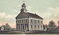
Old High School around 1905
-
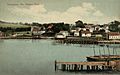
Harbor view in 1908


See also
 In Spanish: Thomaston (Maine) para niños
