
Warren, Maine facts for kids
Quick facts for kids
Warren, Maine
|
|
|---|---|

St. George River and Main Street c. 1908
|
|

Location in Knox County and the state of Maine.
|
|
| Country | United States |
| State | Maine |
| County | Knox |
| Incorporated | 1776 |
| Villages | Warren East Warren South Warren Warren Station Wattons Mill White Oak Corner Whitney Corner |
| Area | |
| • Total | 48.75 sq mi (126.26 km2) |
| • Land | 46.47 sq mi (120.36 km2) |
| • Water | 2.28 sq mi (5.91 km2) |
| Elevation | 20 ft (6 m) |
| Population
(2020)
|
|
| • Total | 4,865 |
| • Density | 105/sq mi (40.4/km2) |
| Time zone | UTC-5 (Eastern (EST)) |
| • Summer (DST) | UTC-4 (EDT) |
| ZIP code |
04864
|
| Area code(s) | 207 |
| FIPS code | 23-80215 |
| GNIS feature ID | 0582790 |
| Website | www.town.warren.me.us |
Warren is a town in Knox County, Maine, United States. In 2020, 4,865 people lived here. The town includes several small communities like East Warren, Warren, and South Warren. South Warren is home to the Maine State Prison.
Contents
History of Warren, Maine
Warren was once part of a large land area called the Waldo Patent. It was known as the Upper Town of St. Georges Plantation. The first settlers arrived in 1736. They were Scots-Irish families from Londonderry. Brigadier-General Samuel Waldo helped them settle the land.
Early Challenges and Forts
Life was hard for the early settlers because of the French and Indian Wars. In 1753, a blockhouse (a small fort) was built for protection. Captain Thomas Kilpatrick was in charge of this fort. During the wars from 1754 to 1758, people often had to hide in the blockhouse. They also found safety in another fort in nearby Cushing.
The fighting ended in 1759 after the Fall of Quebec. This battle was a big win for the British. On November 7, 1776, the Upper Town of St. Georges Plantation officially became a town. It was named Warren to honor Joseph Warren, a hero of the American Revolutionary War.
Industries and Growth
In early Warren, Hay was the main crop grown by farmers. Shipbuilding was also a very important industry. Between 1770 and 1850, people in Warren built 224 ships. These ships ranged greatly in size.
Warren also had quarries where workers dug up granite and limestone. The falls on the St. George River provided water power. This power helped run the first sawmill, built in 1785. Later, factories made woolen clothes and snowshoes. The Knox and Lincoln Railroad opened in 1871, helping the town grow even more.
The Georges River Canal
The Georges River Canal system was built to help move goods. It was named after Henry Knox, who bought the locks in 1794. Charles Barrett first built the canal in 1793. It connected the St. George River to St. George Lake. This made it easier to ship lumber and lime.
After Knox died in 1806, the canal's locks fell apart. In 1848, the Georges Canal Company reopened it. But by 1877, the canal was not used much anymore. The new railroad made it less important. Today, you can still see parts of the canal banks and one lock in Warren. These were uncovered during a river cleanup project in 1966.
Important Firsts and Changes
In 1853, Warren made history. The town elected Olive Rose as the County Register of Deeds. She was the first woman to hold an elected public office in the United States. In 1860, Warren became part of Knox County. This new county was created from parts of Waldo and Lincoln counties.
Since 2002, South Warren has been home to the Maine State Prison. This large facility houses many people. The prison's gift shop, which sells items made by people in the prison, is still in Thomaston.
Peterborough: A Historic Community
In South Warren, there was once a special community called Peterborough. It was a settlement for Black people, first started in 1782. There are a few stories about how this community began.
Founding Stories of Peterborough
One story says that Amos Peters, a Black veteran of the American Revolution, worked for General Henry Knox. When Amos married Sarah, Knox gave them land to live on. This land became Peterborough. Amos and Sarah Peters were freed from slavery in 1780.
Another story suggests that General Knox brought Black staff to work at his mansion. As his estate became crowded, he sent some families to live in the new settlement. A third idea is that many early settlers were "limecoasters." These were Black sailors who worked on ships carrying lime from Thomaston to the southern U.S.
Growth and Decline of Peterborough
No matter how it started, the Peterborough community grew. At its busiest, over three hundred people lived there. By 1823, there were enough children for the community to have its own school. In 1845, the town of Warren gave money to build a schoolhouse in Peterborough.
The school had both Black and white teachers. About 24 to 30 students attended each year. The school building was also used for church services and social events.
After the American Civil War, the number of people in Peterborough began to drop. One reason might be that the shipbuilding industry in the area declined. Also, Black people were often not allowed to work in factories. The last descendants of the original settlers moved away in 1961. Today, newer houses stand in the area, and no one living there has ties to the original community.
Geography of Warren
Warren covers about 48.75 square miles (126.26 square kilometers). Most of this area is land, with some water. The Back River flows through the town. Warren is located where the ocean's tide reaches the St. George River.
Major roads like U.S. Route 1 and state routes 90, 131, and 235 cross through Warren. The town shares borders with several other towns. These include Union to the north, Rockport to the northeast, and Thomaston to the southeast.
Population and People
| Historical population | |||
|---|---|---|---|
| Census | Pop. | %± | |
| 1790 | 646 | — | |
| 1800 | 939 | 45.4% | |
| 1810 | 1,443 | 53.7% | |
| 1820 | 1,825 | 26.5% | |
| 1830 | 2,030 | 11.2% | |
| 1840 | 2,228 | 9.8% | |
| 1850 | 2,428 | 9.0% | |
| 1860 | 2,321 | −4.4% | |
| 1870 | 1,974 | −15.0% | |
| 1880 | 2,166 | 9.7% | |
| 1890 | 2,037 | −6.0% | |
| 1900 | 2,069 | 1.6% | |
| 1910 | 1,812 | −12.4% | |
| 1920 | 1,500 | −17.2% | |
| 1930 | 1,429 | −4.7% | |
| 1940 | 1,458 | 2.0% | |
| 1950 | 1,576 | 8.1% | |
| 1960 | 1,678 | 6.5% | |
| 1970 | 1,864 | 11.1% | |
| 1980 | 2,566 | 37.7% | |
| 1990 | 3,192 | 24.4% | |
| 2000 | 3,794 | 18.9% | |
| 2010 | 4,751 | 25.2% | |
| 2020 | 4,865 | 2.4% | |
| U.S. Decennial Census | |||
Warren's Population in 2010
In 2010, Warren had 4,751 people living in 1,508 households. About 1,086 of these were families. The town had about 102 people per square mile. Most residents (95.3%) were White. Other groups included African American, Native American, and Asian people.
About 32.1% of households had children under 18. Many households (56.0%) were married couples. The average age in Warren was 39.9 years. About 18.4% of residents were under 18. The town's population was 59.1% male and 40.9% female.
Education in Warren
Regional School Unit 40 manages the public schools in Warren. The Warren Community School is located right in town.
For older students, Medomak Valley Middle School and Medomak Valley High School are in nearby Waldoboro. The Warren Free Public Library is also in Warren, offering books and resources for everyone.
Places to Visit
- Lie-Nielsen Toolworks
Famous People from Warren
- Norman Wallace Lermond, a naturalist and activist
- Ellis Spear, a general during the Civil War
- Samuel Thatcher, who served in the U.S. Congress
Images for kids
-
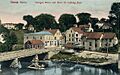
St. George River and Main Street, Warren, Maine
-
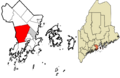
Location in Knox County and the state of Maine
See also
 In Spanish: Warren (Maine) para niños
