Thompson Peak (Arizona) facts for kids
Quick facts for kids Thompson Peak |
|
|---|---|

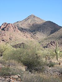
Thompson Peak, McDowell Mountains
|
|
| Highest point | |
| Elevation | 3,984 ft (1,214 m) NAVD 88 |
| Prominence | 762 ft (232 m) |
| Geography | |
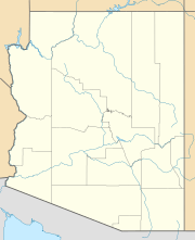
| Location | Maricopa County, Arizona, U.S. |
| Parent range | McDowell Mountains |
| Topo map | USGS McDowell Peak |
Thompson Peak is a cool mountain located in the McDowell Mountains in Arizona, USA. It stands tall about 20 miles (that's about 32 kilometers) northeast of the city of Phoenix, Arizona. This peak reaches a height of 3,984 feet, which is almost 4,000 feet! That's like stacking over 300 school buses on top of each other.
On top of Thompson Peak, you can find special towers. These towers are used for radio communication by amateur radio enthusiasts and also by the government of Maricopa County. A special road helps people get to the top from a town called Fountain Hills.
Thompson Peak: A Mountain in Arizona
Thompson Peak is an important part of the McDowell Mountains. This mountain range is a group of hills and peaks in the desert landscape of Arizona. It's a well-known landmark in the area. The peak's location makes it a great spot for communication towers.
Where is Thompson Peak?
Thompson Peak is found in Maricopa County, which is a large county in Arizona. It's quite close to a big city, Phoenix. Even though it's near a city, the mountain offers amazing views of the desert and the surrounding areas. Its position helps with sending radio signals far away.
What's on Top of the Peak?
The very top of Thompson Peak is home to several towers. These are not just any towers; they are used for important radio communication. Some are for "amateur radio," which is a hobby where people talk to each other over long distances using radio waves. Others are for the local government of Maricopa County. These towers help with things like emergency services and other public communications.
Getting to the top of the peak is possible thanks to a service road. This road starts from the town of Fountain Hills. It's mainly used by people who need to work on the towers.
 | Kyle Baker |
 | Joseph Yoakum |
 | Laura Wheeler Waring |
 | Henry Ossawa Tanner |


