Thornton, Arkansas facts for kids
Quick facts for kids
Thornton, Arkansas
|
|
|---|---|

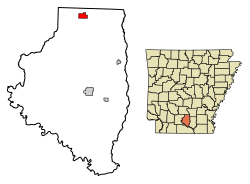
Location of Thornton in Calhoun County, Arkansas.
|
|
| Country | United States |
| State | Arkansas |
| County | Calhoun |
| Area | |
| • Total | 1.94 sq mi (5.03 km2) |
| • Land | 1.92 sq mi (4.98 km2) |
| • Water | 0.02 sq mi (0.04 km2) |
| Elevation | 305 ft (93 m) |
| Population
(2020)
|
|
| • Total | 339 |
| • Density | 176.20/sq mi (68.01/km2) |
| Time zone | UTC−6 (Central (CST)) |
| • Summer (DST) | UTC−5 (CDT) |
| ZIP code |
71766
|
| Area code | 870 |
| FIPS code | 05-69050 |
| GNIS feature ID | 2405588 |
Thornton is a small city located in Calhoun County, Arkansas, in the United States. In 2020, about 339 people lived there. It is part of the larger Camden, Arkansas micropolitan area, which is a group of nearby towns and cities.
Contents
Where is Thornton Located?
Thornton is found in the northern part of Calhoun County. A main road, U.S. Route 79, goes right through the city. This road leads northeast about 6 miles (10 km) to Fordyce. It also goes southwest about 26 miles (42 km) to Camden.
Another road, U.S. Route 167, crosses the southeast edge of Thornton. This road goes north to meet US 79 and Fordyce. It also goes south about 16 miles (26 km) to Hampton. Hampton is the main town in Calhoun County.
The United States Census Bureau says that Thornton covers a total area of about 1.94 square miles (5.0 square kilometers). A very small part of this area, about 0.02 square miles (0.04 square kilometers), is water.
How Many People Live in Thornton?
| Historical population | |||
|---|---|---|---|
| Census | Pop. | %± | |
| 1880 | 150 | — | |
| 1890 | 132 | −12.0% | |
| 1910 | 611 | — | |
| 1920 | 1,312 | 114.7% | |
| 1930 | 550 | −58.1% | |
| 1960 | 658 | — | |
| 1970 | 746 | 13.4% | |
| 1980 | 711 | −4.7% | |
| 1990 | 502 | −29.4% | |
| 2000 | 517 | 3.0% | |
| 2010 | 407 | −21.3% | |
| 2020 | 339 | −16.7% | |
| U.S. Decennial Census | |||
In 2000, there were 517 people living in Thornton. These people made up 206 households. A household is a group of people living in the same home. Out of these, 142 were families.
Most people in Thornton were White (56.48%) or Black/African American (41.78%). A small number were Native American or from two or more races. About 1% of the people were Hispanic or Latino.
About 32.5% of households had children under 18 living with them. Many households (51.9%) were married couples. About 13.1% had a female head of the house with no husband. The average household had 2.51 people.
The median age in the city was 37 years old. This means half the people were younger than 37 and half were older.
What is Thornton's Climate Like?
The weather in Thornton has hot and humid summers. Winters are usually mild to cool. This type of weather is called a humid subtropical climate. On climate maps, it is shown as "Cfa".
Education in Thornton
Students in Thornton go to schools in the Bearden School District. The original Thornton School District joined with the Bearden district on July 1, 1985.
Famous People from Thornton
- Buddy Turner: He used to be a member of the Arkansas House of Representatives. This is where laws are made for the state of Arkansas.
See also
 In Spanish: Thornton (Arkansas) para niños
 | Delilah Pierce |
 | Gordon Parks |
 | Augusta Savage |
 | Charles Ethan Porter |

