
Thredbo River facts for kids
Quick facts for kids Thredbo River |
|
|---|---|

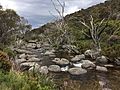
Thredbo River from the Alpine Way in Kosciuszko National Park.
|
|
| Other name(s) | Crackemback River, Crackenback River |
| Country | Australia |
| State | New South Wales |
| Region | Australian Alps (IBRA), Snowy Mountains |
| Local government area | Snowy Monaro Regional Council |
| Town | Thredbo |
| Physical characteristics | |
| Main source | Mount Leo, Snowy Mountains below South Rams Head 1,550 m (5,090 ft) |
| River mouth | confluence with the Snowy River Lake Jindabyne 901 m (2,956 ft) |
| Length | 40 km (25 mi) |
| Basin features | |
| River system | Snowy River catchment |
| Tributaries |
|
| National park | Kosciuszko NP |
The Thredbo River is a river in the Snowy Mountains region of New South Wales, Australia. It is a river that flows all year round. The Thredbo River is part of the larger Snowy River system.
About the Thredbo River
The Thredbo River starts high up in the mountains. Its source is below South Rams Head, near Mount Leo. This area is inside the beautiful Kosciuszko National Park.
Where the River Flows
The river flows next to a road called the Alpine Way. It travels west and northwest near a place called Dead Horse Gap. Then, it turns north and goes through the small village of Thredbo.
Along its journey, four smaller streams join the Thredbo River. One of these is the Little Thredbo River. Finally, the Thredbo River flows into Lake Jindabyne. This lake was formed by the Jindabyne Dam. Inside Lake Jindabyne, the Thredbo River meets the Snowy River.
The river drops about 649 meters (2,129 feet) over its 40-kilometer (25-mile) path. This means it flows downhill quite a bit!
Water and Weather
The amount of water in the Thredbo River changes with the weather. In spring, there is a lot of water. This is because the snow high up in the mountains melts.
During winter, the river area gets very cold. It can have lots of snow and ice. This is typical for rivers in alpine (mountain) areas.
Images for kids
-
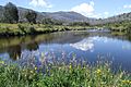
Thredbo River near the Diggings campground in Kosciuszko National Park.
-
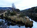
The Thredbo River (on the right) meets the Little Thredbo River (on the left) at Bullocks Flat.
-
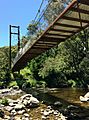
A bridge crosses the Thredbo River for the Thredbo Valley Track.
-
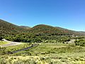
The Thredbo River at the eastern edge of Thredbo Village.
-

The Thredbo River upstream from Thredbo Village.
-
Another view of the Thredbo River upstream from Thredbo Village.


