
Throop, Pennsylvania facts for kids
Quick facts for kids
Throop, Pennsylvania
|
|
|---|---|
|
Borough
|
|

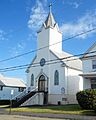
Holy Trinity Polish National Catholic Church
|
|
| Motto(s):
"A Great Place to Live!"
|
|

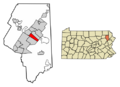
Location of Throop in Lackawanna County, Pennsylvania
|
|

Throop, Pennsylvania
Location in Pennsylvania

Throop, Pennsylvania
Location in the United States
|
|
| Country | United States |
| State | Pennsylvania |
| County | Lackawanna |
| Area | |
| • Total | 4.97 sq mi (12.87 km2) |
| • Land | 4.97 sq mi (12.87 km2) |
| • Water | 0.00 sq mi (0.00 km2) |
| Elevation | 846 ft (258 m) |
| Population
(2020)
|
|
| • Total | 4,078 |
| • Estimate
(2021)
|
4,081 |
| • Density | 784.22/sq mi (302.79/km2) |
| Time zone | UTC-5 (EST) |
| • Summer (DST) | UTC-4 (EDT) |
| Zip Code |
18512
|
| Area code(s) | 570 |
| FIPS code | 42-76648 |
Throop /ˈtruːp/ is a small town, called a borough, in Lackawanna County, Pennsylvania. It's right next to the city of Scranton. Long ago, many people in Throop worked in coal mining and making silk. In 1900, about 2,204 people lived here. By 2020, the population was 4,078.
Contents
Discovering Throop
Throop is located at 41°26′44″N 75°36′52″W / 41.44556°N 75.61444°W. It covers about 5 square miles (12.87 square kilometers) of land.
Where is Throop Located?
Throop is surrounded by other towns. To the northeast, you'll find Olyphant. Blakely is to the north, and Dickson City is to the northwest. Scranton is to the west, and Dunmore is to the south.
Throop's Interesting Past
Throop has a rich history, including important events and unique traditions.
A Look Back in Time
On April 7, 1911, a very sad event happened at the Price-Pancoast Colliery. A big fire broke out, and 72 coal miners lost their lives. This was one of the worst mining accidents in the area's history.
Environmental Cleanup Efforts
There's a piece of land in Throop that used to be a place where batteries were processed. This facility closed in 1982. Since the late 1980s, government groups like the United States Environmental Protection Agency have been working to clean up the area. They are making sure the land is safe for everyone.
The Fun Cow Flop Event
One of Throop's most popular summer events is the annual Cow Flop! The Throop Booster Club organizes it. This tradition started in the late 1980s. The Cow Flop helps raise money for youth baseball and softball programs in the borough. It usually brings in about $10,000 each year!
The Cow Flop used to be a one-day event, but since 2007, it's a two-day festival. It includes a parade, fireworks, music, food, and lots of other fun things to do. More than 100 volunteers, mostly parents and Booster Club members, help make it happen.
The main part of the Cow Flop is a special raffle. People buy tickets for squares on a field. Then, a cow is brought onto the field. Wherever the cow "flops" (relieves itself) determines the winning square! Raffle tickets cost $10, and the winner gets $5,000.
People of Throop
The population of Throop has changed over the years.
| Historical population | |||
|---|---|---|---|
| Census | Pop. | %± | |
| 1900 | 2,204 | — | |
| 1910 | 5,133 | 132.9% | |
| 1920 | 6,672 | 30.0% | |
| 1930 | 8,027 | 20.3% | |
| 1940 | 7,382 | −8.0% | |
| 1950 | 5,861 | −20.6% | |
| 1960 | 4,732 | −19.3% | |
| 1970 | 4,307 | −9.0% | |
| 1980 | 4,166 | −3.3% | |
| 1990 | 4,070 | −2.3% | |
| 2000 | 4,010 | −1.5% | |
| 2010 | 4,088 | 1.9% | |
| 2020 | 4,078 | −0.2% | |
| 2021 (est.) | 4,081 | −0.2% | |
| Sources: | |||
In 2010, there were 4,088 people living in Throop. Most residents were White (96%). About 23.5% of households had children under 18. The average household had 2.30 people. The median age in Throop was 42.4 years old.
Education in Throop

Throop is part of the Mid Valley School District.
Past and Present Schools
When coal mining was a big industry, Throop had many neighborhood schools. These included the Columbus School, Jefferson School, Lincoln School, Pershing School, Washington School, and Wilson School. Throop High School was also a central part of the community.
As the number of people in Throop changed, most of these smaller schools closed. The Washington School was the last one to stay open. The Wilson School became St. Anthony's School, but it closed in the mid-1970s.
In 1969, the school districts of Olyphant, Dickson City, and Throop joined together. They formed the Mid Valley School District. Throop High School then became Throop Elementary School. Today, the district's two main schools, Mid Valley Secondary Center and Mid Valley Elementary Center, are both located in Throop.
Getting Around Throop
Several important roads help people travel in and out of Throop.
Major Roads and Highways
Interstate 81 is the main highway in the Throop area. Other major highways like Interstate 84, Interstate 380, and U.S. Route 6 connect with I-81 nearby in Dunmore. State Route 347 is another important road within Throop.
Images for kids
-
Holy Trinity Polish National Catholic Church
-
Location of Throop in Lackawanna County, Pennsylvania
See also
 In Spanish: Throop (Pensilvania) para niños
