Tiber Island (District of Columbia) facts for kids

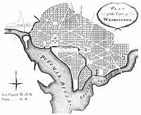
Andrew Ellicott's revision of L'Enfant's Plan showing Washington City Canal and Tiber Island (SW quadrant of the District of Columbia)
|
|
| Geography | |
|---|---|
| Location | Potomac River, Washington, D.C. |
| Coordinates | 38°53′10″N 77°01′30″W / 38.88611°N 77.02500°W |
| Total islands | 1 |
| Administration | |
|
United States
|
|
| Demographics | |
| Population | 0 |
| Additional information | |
| No longer exists. Today it is the southwest Quadrant of Washington, DC | |
Tiber Island, also known as The Island, was a unique piece of land in Washington, D.C.. It was a man-made island, meaning people created it. This happened when the Washington City Canal was dug. This canal connected two streams, Tiber Creek and James Creek. By digging the canal, a peninsula (land almost surrounded by water) became a true island.
Over time, the canals were filled in. This reconnected the island to the main land. Today, areas like the Southwest Waterfront, Buzzard Point, National Mall, and L'Enfant Plaza were once part of this island. Because these areas were separated from the rest of the city, people used to call the whole area "The Island."
Contents
How Tiber Island Was Formed
Tiber Island was not a natural island. It was created by people in Washington, D.C. This happened when the Washington City Canal was built. The canal was dug to link two important streams: Tiber Creek and James Creek.
From Peninsula to Island
Before the canal, the land was a peninsula. This means it was mostly surrounded by water but still connected to the mainland on one side. When the canal was finished, it cut off this connection. This turned the peninsula into an island. It was located southwest of the U.S. Capitol building.
Rejoining the Mainland
Later, the canals that created Tiber Island were filled in. This process changed the landscape of Washington, D.C. Once the canals were gone, the island was no longer separated by water. It became part of the mainland again.
Areas Once on the Island
Many well-known places in Washington, D.C., were once part of Tiber Island. These areas were once isolated by water.
- Southwest Waterfront: A lively area along the water.
- Buzzard Point: A peninsula where the Anacostia River meets the Potomac River.
- National Mall: The large, open park area with monuments and museums.
- L'Enfant Plaza: A major complex of buildings and a plaza.
Because these areas were cut off from the rest of the city, people gave the whole area the nickname "The Island."
Legacy of the Island's Name
Even though Tiber Island no longer exists as a separate landmass, its name lives on. The Tiber Island Cooperative Homes is a housing community in Washington, D.C. It was named after this historic island, keeping its memory alive in the city.

