
Tievebaun Mountain facts for kids
Quick facts for kids Tievebaun Mountain |
|
|---|---|
| Taobh Bán | |

Location in island of Ireland
|
|
| Highest point | |
| Elevation | 611 m (2,005 ft) |
| Prominence | 106 m (348 ft) |
| Parent peak | none - HP Ireland |
| Naming | |
| Language of name | Irish |
| Geography | |
| Location | County Leitrim, Republic of Ireland |
| Parent range | Dartry Mountains |
Tievebaun Mountain is a cool mountain located in County Leitrim, Republic of Ireland. Its name, Taobh Bán, comes from the Irish language and means "grassy slope". This mountain stands tall at 611 meters (about 2,005 feet) above sea level. It is well-known for its impressive cliffs. The very top of Tievebaun Mountain is called "Eagles Rock".
About Tievebaun Mountain
Tievebaun Mountain is an important part of the Dartry Mountains range. It is the third highest mountain in this range. It also holds the title of the second highest mountain in all of County Leitrim. This makes it a significant landmark in the area.
Where is Tievebaun Mountain?
Tievebaun Mountain is found in County Leitrim, which is in the northwest part of the Republic of Ireland. Its exact location can be pinpointed using special coordinates: 54.397132° N latitude and 8.357281° W longitude. These numbers help people find its spot on a map.
What Makes Tievebaun Special?
- Height: Tievebaun Mountain reaches 611 meters (2,005 feet) into the sky.
- Cliffs: It is famous for its steep cliffs, which are popular with climbers and offer amazing views.
- Eagles Rock: The highest point of the mountain is called Eagles Rock. This name suggests that eagles might have once nested there, or perhaps still do!
- Ranking: It's the third tallest in the Dartry Mountains and the second tallest in County Leitrim.
-
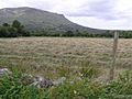
Ahanalish Townland, a beautiful area near the mountain.
-
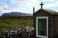
Tobar Phadraig, Knockbrack, a local landmark.
-
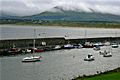
Mullaghmore Harbour, a nearby coastal spot.


