Tindall, Missouri facts for kids
Quick facts for kids
Tindall, Missouri
|
|
|---|---|

Location of Tindall, Missouri
|
|
| Country | United States |
| State | Missouri |
| County | Grundy |
| Area | |
| • Total | 0.13 sq mi (0.34 km2) |
| • Land | 0.13 sq mi (0.34 km2) |
| • Water | 0.00 sq mi (0.00 km2) |
| Elevation | 791 ft (241 m) |
| Population
(2020)
|
|
| • Total | 46 |
| • Density | 348.48/sq mi (134.47/km2) |
| Time zone | UTC-6 (Central (CST)) |
| • Summer (DST) | UTC-5 (CDT) |
| FIPS code | 29-73348 |
| GNIS feature ID | 2397696 |
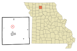
Tindall is a small city located in Grundy County, Missouri, in the United States. According to the 2020 census, 46 people live there. It's a quiet community in the heart of Missouri.
Contents
History of Tindall
Tindall was first planned and built in 1872. This happened when the railroad tracks were extended to reach that area. Before that, a post office was set up in Tindall in 1869. This post office helped people send and receive mail until 1967. The city is named after Jacob A. Tindall. He was an officer who served during the American Civil War.
Geography of Tindall
Tindall is located along U.S. Route 65. This road connects it to other towns. It is about five miles north of Trenton. It is also five miles south of Spickard.
The Weldon River flows near Tindall. It passes about 1.5 miles to the west of the city. The United States Census Bureau says that Tindall covers a total area of about 0.13 square miles (0.34 square kilometers). All of this area is land, with no water.
Population and People
| Historical population | |||
|---|---|---|---|
| Census | Pop. | %± | |
| 1930 | 134 | — | |
| 1940 | 125 | −6.7% | |
| 1950 | 102 | −18.4% | |
| 1960 | 94 | −7.8% | |
| 1970 | 92 | −2.1% | |
| 1980 | 104 | 13.0% | |
| 1990 | 46 | −55.8% | |
| 2000 | 65 | 41.3% | |
| 2010 | 77 | 18.5% | |
| 2020 | 46 | −40.3% | |
| U.S. Decennial Census | |||
This table shows how the number of people living in Tindall has changed over many years.
2010 Census Information
In 2010, a count of the population was done. This count, called a census, showed that 77 people lived in Tindall. These people lived in 32 different homes, called households. Out of these, 20 were families.
The population density was about 592 people per square mile. This means that for every square mile of land, there were about 592 people. There were also 34 housing units, which are places where people can live.
Everyone living in the city at that time was White.
- About 25% of the homes had children under 18 living there.
- Half of the homes (50%) had married couples living together.
- A small number of homes (6.3%) had a female head of the household with no husband.
- Another small number (6.3%) had a male head of the household with no wife.
- About 37.5% of the homes were not families. This means they might have been individuals living alone or roommates.
About 34.4% of all households were made up of just one person. And 25% of these single-person households had someone who was 65 years old or older. The average number of people in a household was 2.41. For families, the average size was 3.05 people.
The average age of people in the city was 43.5 years old.
- About 31.2% of the people were under 18 years old.
- Only 2.6% were between 18 and 24 years old.
- About 18.2% were between 25 and 44 years old.
- A larger group, 33.8%, were between 45 and 64 years old.
- About 14.3% were 65 years old or older.
When looking at gender, 46.8% of the people in Tindall were male. The other 53.2% were female.
See also
 In Spanish: Tindall (Misuri) para niños

