Tipón facts for kids
|
Parque Arqueológico de Tipón
|
|
 |
|
| Location | Peru, Cusco Region, Quispicanchi Province, Oropesa District |
|---|---|
| Coordinates | 13°34′15″S 71°46′59″W / 13.57083°S 71.78306°W |
| Area | 239 hectares (590 acres) |
| History | |
| Abandoned | no |
| Cultures | pre-Inca and Inca |
| Site notes | |
| Excavation dates | 1970 - present |
| Public access | yes (ticket) |
Tipón is an amazing ancient park built by the Incas. It dates back to the early 1400s. This special place is located in Peru, about 22 kilometers (14 miles) southeast of Cusco. It sits high up in the mountains, between 3,250 meters (10,660 feet) and 3,960 meters (13,000 feet) above sea level.
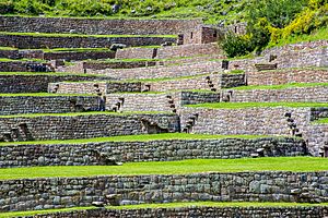
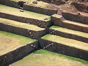
The park has many old ruins, protected by a strong wall that is about 6 kilometers (4 miles) long. The most famous part of Tipón is its incredible terraces. These terraces are very precise and have straight angles. They are watered by a clever system of canals and fountains. This system brings water from a natural spring. Tipón also has old living areas and many ancient rock carvings called petroglyphs.
The Incas were very skilled engineers. Their water system, with its canals, fountains, and stone structures, shows how advanced they were. They knew a lot about managing water.
Archaeologists have been digging and restoring Tipón since the 1970s. This work is still happening today. Experts believe Tipón was likely a special estate for the Inca rulers or important families. It was probably built during the time of Pachacuti or his son, Topa Inca Yupanqui. It's also thought that important ceremonies took place here.
Tipón might have even been used as a farming laboratory. This is because the area has different mini-climates, a steady water supply, and rich soil. Today, Tipón is a popular place for tourists visiting the Cusco area.
Contents
- Exploring Tipón: An Ancient Inca Site
- The History of Tipón
- Amazing Engineering at Tipón Park
- Terraces: Inca Farming Steps
- Monumental Terraces: A Masterpiece
- Fountains: Water for Life and Ceremony
- The Outer Wall: A Strong Defense
- Inca Canals and Aqueduct: Water Highways
- Cancha Inca: An Ancient Neighborhood
- Iglesia Raqui: A Mysterious Building
- Sinkuna Cancha: Blending with Nature
- Intiwatana: Where the Sun Was Tied
- Ceremonial Plaza: A Sacred Space
- Cruzmoqo: The Highest Point
- Pukara: An Ancient Urban Area
- See also
Exploring Tipón: An Ancient Inca Site
The Tipón complex is located near Oropesa. This area is southeast of Cusco, along the road to Puno.
Archaeologists have divided Tipón into different parts. These include areas for farming and living, like Pukara and Intihuatana. There are also ceremonial spots, such as Cruzmoqo and the fountains. The site also has Qullqas, which were storehouses, and cemeteries. The upper part of Tipón has three Inca canals. These canals bring water from the Pukara river to water the whole complex. One of these canals even flows over an ancient stone aqueduct.
In 1984, Tipón was named a National Archaeological Park of Peru. In 2006, it was added to the List of Historic Civil Engineering Landmarks by the American Society of Civil Engineers. The park covers about 239 hectares (590 acres). It is bordered by two ravines with streams that meet at the bottom of the complex. These streams then flow into the Huatanay river.
Tipón is in a volcanic area. The Incas used strong rocks like basalt and andesite to build the terraces and buildings. They shaped these stones carefully for their needs.
What Does "Tipón" Mean?
The exact meaning of the name "Tipón" is not known. It is not a Quechua word. Some think it might come from "timpuee," meaning "boiling place." This could be because many people gathered there, or it was a very busy place in Inca times. However, no one is completely sure about its name's origin.
The History of Tipón
Archaeological studies show that people lived in Tipón for a very long time. It was continuously occupied from about 1000 BCE by the Marcavalle culture. Later cultures included Chanapata, Qotakalli, Huari, and Killke. Finally, the Incas lived there from the 13th century until 1572.
Items found at the site prove that Tipón was an important place for ceremonies, government, and religion during the Inca period. Cruzmoqo hill, at the top of Tipón, was likely a key spot for signals, communication, and watching over the road to the Sacred Valley.
Tipón's original name might have been Muyna or Moyna. It was an important settlement for the Pinagua tribe before the Incas. Later, it became an Inca llaqta, which means an administrative town. The Pinaguas might have been part of the Ayarmaca kingdom. This kingdom rebelled against the Incas but was finally defeated by Pachacuti in the mid-1400s.
Some historians believe Tipón was built by Viracocha Inca. He might have built it as a home and safe place for his father, Yawar Waqaq. Yawar Waqaq was said to have been overthrown after running away during a rebellion. However, later studies suggest that it was Viracocha who fled, not to Tipón, but to the Sacred Valley. These studies do confirm a strong connection between Yawar Waqaq and the Tipón site.
The name "Tipón" first appears in a document from the 1500s. It was in the will of Doña Tomasina de la Vega, an early owner of the Quispicanchi estate. She mentioned the "lands of Tipón and Guaypar."
Amazing Engineering at Tipón Park
Tipón is amazing because it uses both surface water and underground water in a smart way. This was done even before modern engineering existed. While Tipón's water systems are different from those at Machu Picchu, they show similar engineering ideas. This means that technology was shared between these two separate places. For example, both sites have stone-lined canals, vertical drains, and ways to collect spring water. The engineers at both Machu Picchu and Tipón understood how water flows and how to control it. Tipón's ceremonial fountain is also similar to many fountains found at Machu Picchu.
Here are some of the most interesting parts of the Tipón archaeological park:
Terraces: Inca Farming Steps
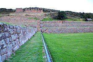
A large part of Tipón is covered by terraced areas, also called "andénes." These terraces are inside the defensive walls. About 100 hectares (247 acres) of the park are terraced. Around 50 hectares (124 acres) of these terraces are watered by canals that bring water from the Pukara river. Many of the stone walls that form the terraces are still in good condition.
Monumental Terraces: A Masterpiece
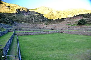
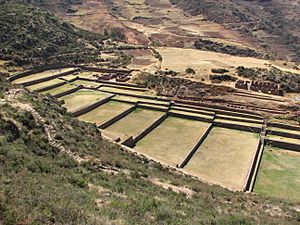
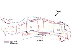
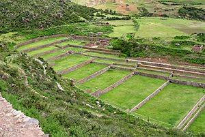
There are 13 main terraces in Tipón. They cover about 3 hectares (7.4 acres) and are located in a shallow valley. These terraces are between 3,380 meters (11,090 feet) and 3,460 meters (11,350 feet) high.
They are known for their U-shaped walls. The stonework is very high quality, showing how carefully the stones were shaped and fitted. The walls are between 1 meter (3 feet) and 5 meters (16 feet) tall, with an average height of 2.5 to 3 meters (8 to 10 feet).
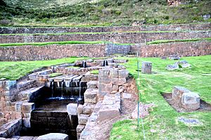
The irrigation system for these terraces is an amazing example of ancient engineering. A large fountain on the highest terrace collects groundwater. This water then flows into three canals that can be used separately or together. There are also special structures that control the water flow for farming. This system also provided water to nearby living areas. Eleven of the 13 terraces get water from the main Tipón spring. The top two terraces are watered by a canal from the Pukara river.
Fountains: Water for Life and Ceremony
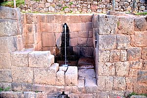
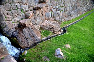
The main monumental fountain was restored in 1999. It is on terrace 11, where a natural spring is collected. The water is channeled and split into two jets, which then divide into four, before joining into a single flow. This flow then becomes the start of the canal system. This fountain provides a steady supply of clean water all year round. The system that collects groundwater has seven underground pipes that spread out in different directions. The fountain itself is beautifully designed with basalt and andesite stonework.
A ceremonial fountain is located on the southeast side of terrace 8. It gets its water from one of the canals fed by the monumental fountain. This water flows underground before reaching the ceremonial fountain. The water then drops into a stone basin and flows into the lower canal system.
The Outer Wall: A Strong Defense
Tipón has a huge outer wall that goes all around the site, making it like a fortress. The wall is about 6 kilometers (4 miles) long. It can be up to 8 meters (26 feet) high, and its width is up to 2 meters (7 feet) at the top and 4 to 6 meters (13 to 20 feet) at the bottom.
Building this wall required a lot of effort and resources. Its style suggests it might have been influenced by the Killke or Wari people. The stonework is simple, but in some areas, the wall has a polygonal shape. The wall follows the shape of the hill, stepping up and down. Part of the wall is built right on top of the natural rock slope. We don't know its original purpose, and more research is needed. In one part of the wall, there is a hole or doorway structure whose use is also unknown.
Inca Canals and Aqueduct: Water Highways
Three irrigation canals collect water from the Pukara river at the northernmost part of the park. They bring water down to the lower lands and homes. The points where the water is taken from the river are outside the outer wall. The canals pass through the wall where the steep land allows for good security.
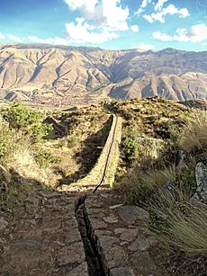
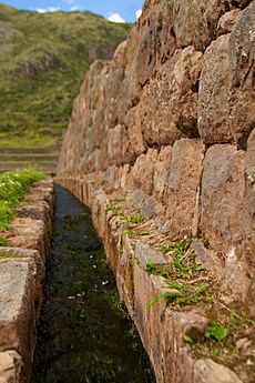
One of these canals, called the main canal, is very well preserved or has been restored along most of its 1.4-kilometer (0.9-mile) stone-lined path. This canal follows the curves of the hill and uses different building techniques. It has retaining walls, sections where earth was cut and filled, and sharp turns to change direction or go around rocks.
This canal provides water for farming near the Intiwatana and Ceremonial plaza. It then passes north of the monumental terraces and reaches Patallaqta. Before reaching Intiwatana, the canal flows over an aqueduct and goes through a tunnel inside the Intiwatana area. Just north of Intiwatana, an aqueduct was built on a rocky outcrop. This structure allowed the water to flow to Intiwatana at the correct level.
Cancha Inca: An Ancient Neighborhood
This group of buildings is located east of monumental terrace 12, near the main fountain. It's a small urban area, or "Inca court." The buildings are arranged in a "U" shape around a central courtyard. They still have their original trapezoidal niches and windows.
Iglesia Raqui: A Mysterious Building
East of terrace 6, there is a restored building that might have been a qullqa, or storehouse. It has doorways, windows, and niches. The building's design allows for a lot of air circulation. One of the larger rooms is rectangular with three trapezoidal openings on the first level. The second level has six openings facing north.
Iglesia Raqui sits at the top of a grand stairway. This stairway is on the southwest side of the monumental terraces and has a three-step water drop. It is an important part of the beautiful view of Tipón's terraces.
Sinkuna Cancha: Blending with Nature
This living area is just above monumental terrace 1. It is about 90 meters (295 feet) long from east to west. It has a large half-circular structure on the east side. This area is made up of several enclosures that blend with nature. Terraces were created by cutting and filling the land, with retaining walls where needed. The buildings here are not arranged in the usual Inca "canchas" (groups of buildings around a central patio). Instead, they are freely placed. More digging is needed to fully understand this complex area.
Intiwatana: Where the Sun Was Tied
Intiwatana means "where the sun is tied" or "mooring of the sun." It was a place where the Incas observed the sun's movements, like solstices and equinoxes. This helped them with farming. The name was given by Ephrain Squier in 1877 and confirmed by Hiram Bingham III, who discovered Machu Picchu.
This area is on a rocky hill at 3,525 meters (11,565 feet) high. At the east end of the ruins, there is a small, natural pyramid-shaped rock. Around this rock, four square terraces and a stairway were built with simple stonework. Facing the pyramid is a courtyard with two triple-jamb niches.
West of the pyramid, a long street divides two areas with rectangular rooms. These rooms face the pyramid and have trapezoidal niches. The stonework here is very fine. The main canal enters Intiwatana and leaves it after going underground. This provided water to the people living there. The canal was built into the foundations of the buildings. These buildings form a small urban part of a large farming complex with irrigated Inca terraces. Many of these terraces are still used for farming today.
Ceremonial Plaza: A Sacred Space
The "U" shaped Ceremonial plaza is just southwest of the aqueduct. Its opening faces south. It is about 35 by 23 meters (115 by 75 feet). The andesite stonework is excellent. On its northern side, the wall has large trapezoidal niches.
Two water canals from the aqueduct bring water to the plaza. The northeastern canal pours water into a small enclosure, which might have been a ceremonial fountain.
Cruzmoqo: The Highest Point
Cruzmoqo is the highest point in Tipón Archaeological Park, at 3,960 meters (13,000 feet) high. It has important petroglyphs, which are ancient rock carvings. The outer wall surrounds the tip of Cruzmoqo, which might mean it was used for religious purposes or as a signaling station. Terraces around Cruzmoqo are built with finely cut square and rectangular stones.
Several natural rocks here have geometric shapes carved into them. These include double spirals, arrows, lines of dots, and small holes. Cruzmoqo has most of the 29 rocks with petroglyphs found in Tipón Park. Their style is different from the petroglyphs found on the southern slope of the park, which also include animal and human figures. The carvings at the summit show different levels of wear, which means they were made at different times.
Pukara: An Ancient Urban Area
The Inca urban area of Pukara includes buildings and stone terraces. It is located inside and near the northwest outer wall, next to the Pukara river.
Finding old pottery pieces from the Killke culture shows that Pukara existed before the Incas. This area has likely been farmed continuously since the Inca period. The urban part mostly consists of enclosures made with simple stonework. Polygonal stonework is more common at the corners. The openings are trapezoidal, and the inside of the enclosures was covered with clay and straw plaster.
The terraces in Pukara are rectangular in the north and east parts. In the southeast, they have a crescent shape because of the land's natural form. Local farmers still use these terraces today.
See also
 In Spanish: Tipón para niños
 | Anna J. Cooper |
 | Mary McLeod Bethune |
 | Lillie Mae Bradford |


