
Toolbrunup facts for kids
Quick facts for kids Toolbrunup |
|
|---|---|
 |
|
| Highest point | |
| Elevation | 1,052 m (3,451 ft) |
| Geography | |
| Location | Great Southern of Western Australia |
| Parent range | Stirling Range |
Toolbrunup is one of the highest mountains in the Stirling Ranges in Australia. This impressive peak stands 1,052 meters (3,451 feet) tall. It's a popular spot for hikers who want to explore the beautiful nature of Western Australia.
Contents
How Toolbrunup Was Formed
Toolbrunup is made from very old rocks. These rocks started as soft sediments, like sand and mud, that were laid down during a time called the Ediacaran Period. This was a super long time ago, even before dinosaurs!
Over millions of years, these sediments were squashed and heated deep underground. This process changed them into hard rocks like quartzite and shale. Later, the Earth's crust moved, folding these strong rocks upwards to create the mountain we see today.
Early Explorers of Toolbrunup
The first European person known to climb Toolbrunup was a young officer named Ensign Robert Dale. He reached the top in 1832 while exploring the area.
Three years later, in 1835, another explorer named John Septimus Roe also climbed the peak. In the 1840s, a botanist (someone who studies plants) named James Drummond visited Toolbrunup. He returned many times to find and identify different plants growing on the mountain.
The Traditional Owners
The traditional owners of the land around Toolbrunup are the Minang and Koreng peoples. They have lived in this area for thousands of years and have a deep connection to the land.
The name "Toolbrunup" comes from their language. It is also the name of a nearby lake. The name is thought to mean "the place that has water when all else is dry." This shows how important water sources were to the people living there.
Images for kids
-
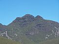
Toolbrunup mountain in the Stirling Range.
See also
In Spanish: Toolbrunup para niños
